
Occasional Showers/Storms Through Sunday
TROPICAL AIR: A moisture laden airmass will stay in place across Alabama through the weekend, and the forecast will continue to highlight occasional showers and thunderstorms. Stronger storms will be capable of dropping lots of rain in a very short amount of time in this airmass, and the NWS maintains a flash flood watch for much of North, Central, and East Alabama through tomorrow evening.
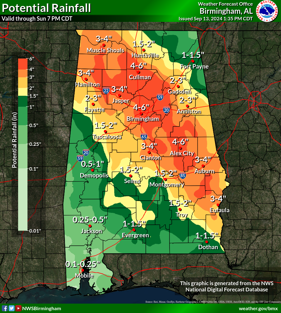
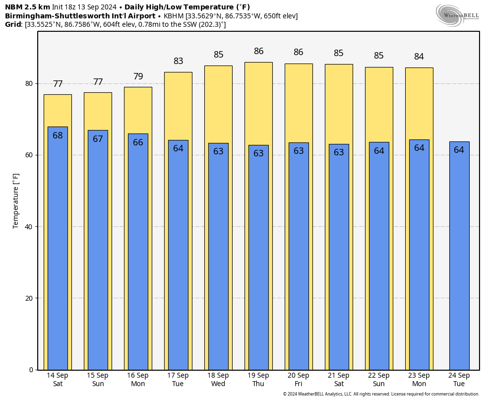
There will some good breaks in the rain over the weekend, but just be ready for a passing shower or storm at any hour. Expect more clouds than sun with highs in the 77-82 degree range both days. No severe storms are expected.
NEXT WEEK: A few showers remain possible Monday, but the rest of the week looks mostly dry with highs in the 80s. A few isolated showers are possible over far South Alabama Tuesday and Wednesday, but even there rain amounts will be light and spotty. See the video briefing for maps, graphics, and more details.
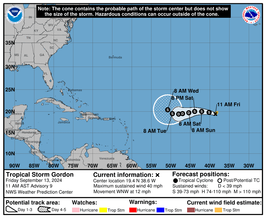
TROPICS: Tropical Storm Gordon has formed in the eastern Atlantic about 990 miles west/northwest of the Cabo Verde Islands. Sustained winds are only 40 mph, and the system is expected to stay far from land through early next week. Gordon has some chance to intensify today before moving deeper into the moisture-starved environment across the tropical Atlantic, and some weakening is anticipated this weekend. While the shear isn’t expected to be too hostile, any re-intensification during next week is expected to be slow, and there is a chance that Gordon could degenerate into a remnant low.
Elsewhere, a non-tropical area of low pressure could form along a frontal boundary a few hundred miles off the southeastern U.S. coastline this weekend. Thereafter, the low may develop some subtropical or tropical characteristics, and a subtropical or tropical depression could form early next week while the system moves generally northwestward toward the coast. NHC gives this a 40 percent chance of development.
FOOTBALL WEATHER: Showers are possible for high school football games across Alabama tonight; temperatures will be in the 70s.
Alabama will take on Wisconsin tomorrow in Madison, WI (11:00a CT kickoff)… the sky will be partly sunny with only a small risk of a passing shower during the second half. Temperatures will rise from 77 degrees at kickoff, to near 81 by the final whistle.
UAB plays at Arkansas tomorrow (3:15p CT kickoff)… the sky will be sunny with temperatures in the mid to upper 80s at kickoff, falling into the low 80s by the end of the game.
Auburn hosts New Mexico tomorrow evening at Jordan Hare Stadium (6:00p CT kickoff)… the sky will be mostly cloudy, and some rain is very possible, if not likely, during the game. Temperatures will be in the mid 70s.
ON THIS DATE IN 1988: Hurricane Gilbert smashed into the Cayman Islands, and as it headed for the Yucatan Peninsula of Mexico strengthened into a monster hurricane, packing winds of 175 mph. The barometric pressure at the center of Gilbert reached 888 mb, a record for any hurricane in the Caribbean, Gulf of Mexico, or the Atlantic Ocean until Hurricane Wilma in 2005. Gilbert covered much of the Gulf of Mexico, producing rain as far away as the Florida Keys.
ON THIS DATE IN 2008: Hurricane Ike made landfall as a Category 2 storm near Galveston, Texas.
Look for my next video briefing here by 6:00 a.m. Monday… enjoy the weekend!
Category: Alabama's Weather, ALL POSTS, Weather Xtreme Videos
About the Author (Author Profile)
James Spann is one of the most recognized and trusted television meteorologists in the industry. He holds the AMS CCM designation and television seals from the AMS and NWA. He is a past winner of the Broadcast Meteorologist of the Year from both professional organizations.Subscribe
If you enjoyed this article, subscribe to receive more just like it.


