
Update: Flood Watches Extended Through Saturday Evening / Discussion on Near Term Flood Threat.
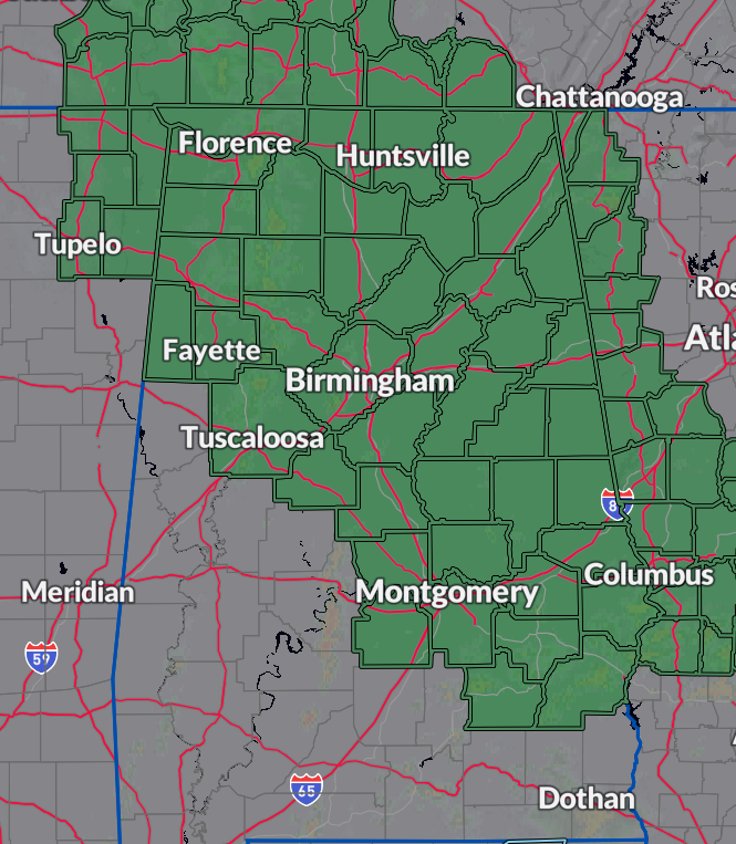
Periods of moderate to heavy rainfall are forecast for portions of Northern and Central Alabama. Flood watches continue to be in effect and have actually been extended through Saturday evening for both the NWS Huntsville and NWS Birmingham county warning areas.
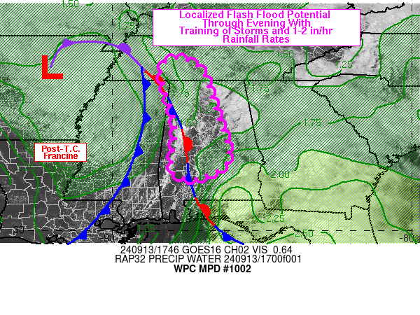
The Weather Prediction Center in the first of two mesoscale precipitation discussions states that the latest model guidance focus on the risk of heavy rain for parts of Alabama where the remnants of Francine continue to linger. We need the rain of course to battle drought conditions, but it is coming in heavy and over a prolonged period and the risk of flooding persists. A narrow axes of very heavy rain (1-2″ / hour) possible across the northern half of the state. Precipitable water values range from 1.3 to 1.7 inches.
Instability is expected to continue to build as we have been seeing breaks in the clouds. Big concern for training storms over the same areas bringing in that flood threat. Please be weather aware for the rest of today and tonight. The flooding threat is in place tonight too. And we may be dealing with a repeat performance tomorrow.
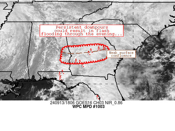
The other discussion focuses on eastern Alabama where we had problems earlier today. More showers and storms are rolling through and could produce rainfall rate of 1-2 inches in an hour.
From NWS Birmingham:
URGENT – IMMEDIATE BROADCAST REQUESTED
Flood Watch
National Weather Service Birmingham AL
102 PM CDT Fri Sep 13 2024
ALZ011>015-017>021-023>029-034>038-041>050-141215-
/O.EXT.KBMX.FA.A.0005.000000T0000Z-240915T0000Z/
/00000.0.ER.000000T0000Z.000000T0000Z.000000T0000Z.OO/
Marion-Lamar-Fayette-Winston-Walker-Blount-Etowah-Calhoun-
Cherokee-Cleburne-Tuscaloosa-Jefferson-Shelby-St. Clair-Talladega-
Clay-Randolph-Bibb-Chilton-Coosa-Tallapoosa-Chambers-Autauga-
Lowndes-Elmore-Montgomery-Macon-Bullock-Lee-Russell-Pike-Barbour-
Including the cities of Hoover, Hayneville, Vernon, Roanoke,
Montgomery, Auburn, Hamilton, Heflin, Talladega, Centre,
Columbiana, Alabaster, Moody, Sylacauga, Oneonta, Clanton, Fort
Deposit, Tallassee, Birmingham, Pell City, Gadsden, Centreville,
Sulligent, Valley, Opelika, Jasper, Dadeville, Prattville,
Lafayette, Ashland, Union Springs, Double Springs, Anniston,
Lanett, Rockford, Tuskegee, Troy, Pelham, Alexander City,
Fayette, Wetumpka, Tuscaloosa, Phenix City, and Eufaula
102 PM CDT Fri Sep 13 2024
…FLOOD WATCH NOW IN EFFECT THROUGH SATURDAY EVENING…
* WHAT…Flash flooding caused by excessive rainfall continues to be
possible.
* WHERE…A portion of central Alabama, including the following
counties, Autauga, Barbour, Bibb, Blount, Bullock, Calhoun,
Chambers, Cherokee, Chilton, Clay, Cleburne, Coosa, Elmore,
Etowah, Fayette, Jefferson, Lamar, Lee, Lowndes, Macon, Marion,
Montgomery, Pike, Randolph, Russell, Shelby, St. Clair, Talladega,
Tallapoosa, Tuscaloosa, Walker and Winston.
* WHEN…Through Saturday evening.
* IMPACTS…Excessive runoff may result in flooding of rivers,
creeks, streams, and other low-lying and flood-prone locations.
Creeks and streams may rise out of their banks. Flooding may occur
in poor drainage and urban areas.
From NWS Huntsville
URGENT – IMMEDIATE BROADCAST REQUESTED
Flood Watch
National Weather Service Huntsville AL
1240 PM CDT Fri Sep 13 2024
ALZ001>010-016-TNZ076-096-097-141000-
/O.EXT.KHUN.FA.A.0003.000000T0000Z-240915T0000Z/
/00000.0.ER.000000T0000Z.000000T0000Z.000000T0000Z.OO/
Lauderdale-Colbert-Franklin AL-Lawrence-Limestone-Madison-Morgan-
Marshall-Jackson-DeKalb-Cullman-Moore-Lincoln-Franklin TN-
Including the cities of Scottsboro, Sheffield, Arab, Decherd,
Fayetteville, Estill Springs, Rainsville, Lynchburg, Moulton, Red
Bay, Albertville, Decatur, Town Creek, Fort Payne, Boaz, Athens,
Cowan, Cullman, Guntersville, Huntsville, Sewanee, Muscle Shoals,
Florence, Winchester, Tuscumbia, and Russellville
1240 PM CDT Fri Sep 13 2024
…FLOOD WATCH NOW IN EFFECT THROUGH SATURDAY EVENING…
* WHAT…Flash flooding caused by excessive rainfall continues to be
possible.
* WHERE…Portions of Alabama, including the following counties,
Colbert, Cullman, DeKalb, Franklin, Jackson, Lauderdale, Lawrence,
Limestone, Madison, Marshall and Morgan and southern middle
Tennessee, including the following counties, Franklin, Lincoln and
Moore.
* WHEN…Through Saturday evening.
* IMPACTS…Excessive runoff may result in flooding of rivers,
creeks, streams, and other low-lying and flood-prone locations.
Flooding may occur in poor drainage and urban areas.
* ADDITIONAL DETAILS…
– Periods of moderate to heavy rainfall are expected through
Saturday. Additional rainfall amounts of 3 to 5 inches are
expected in the heaviest bands of rainfall, with locally
higher amounts. Excessive rainfall will result in runoff and
localized instances of flash flooding.
– http://www.weather.gov/safety/flood
Category: Alabama's Weather, ALL POSTS, Severe Weather, Social Media
About the Author (Author Profile)
Owner of Tornado Talk. Radio broadcast meteorologist with The Storm Report. WeatherBrains Panelist. B.S. Meteorology from Penn State University.Subscribe
If you enjoyed this article, subscribe to receive more just like it.


