
Midday Nowcast: Heavy Rain at Times through the Weekend
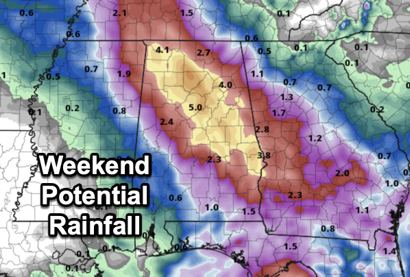
In the wake of Francine, a deep layer of tropical moisture remains across Alabama through Sunday, meaning our forecast will feature occasional showers and thunderstorms today and through the weekend. There will be good breaks, but when the rain comes it could be heavy.
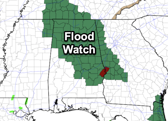
A flood watch remains in effect for much of North and East Alabama. Additional rain of 2-4 inches is possible over the northern and eastern counties over the next three days with some isolated higher amounts possible.
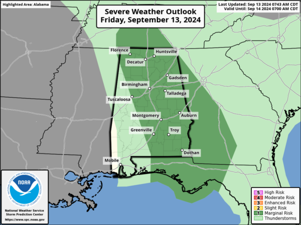
We also note the SPC maintains a low end “marginal risk” of a few brief, isolated tornadoes across mainly the eastern half of the state this afternoon and early tonight. Again, these will be quick spin-ups and very short-lived with little warning.
The overall weather will remain mainly cloudy today and we should continue to see highs in the 70s for most locations.
FRIDAY NIGHT LIGHTS: Showers are possible for high school football games across Alabama tonight; temperatures will be in the 70s.
BIRMINGHAM ALMANAC: For September 13th, the average high for Birmingham is 87° and the average low is 66°. The record high is 99° set in 2019, while the record low is 47° set in 1902. We average 0.14” of precipitation on this date, and the record value is 1.87” set in 1951.
FOOTBALL WEATHER: Alabama will take on Wisconsin tomorrow in Madison, WI (11:00a CT kickoff)… the sky will be partly sunny with only a small risk of a passing shower during the second half. Temperatures will rise from 77 degrees at kickoff, to near 81 by the final whistle.
UAB plays at Arkansas tomorrow (3:15p CT kickoff)… the sky will be sunny with temperatures in the mid to upper 80s at kickoff, falling into the low 80s by the end of the game.
Auburn hosts New Mexico tomorrow evening at Jordan Hare Stadium (6:00p CT kickoff)… the sky will be mostly cloudy, and some rain is very possible, if not likely, during the game. Temperatures will be in the mid 70s.
NEXT WEEK: A few showers remain possible Monday, but the rest of the week looks mostly dry with highs in the 80s. A few isolated showers are possible over far South Alabama Tuesday and Wednesday, but even there rain amounts will be light and spotty.
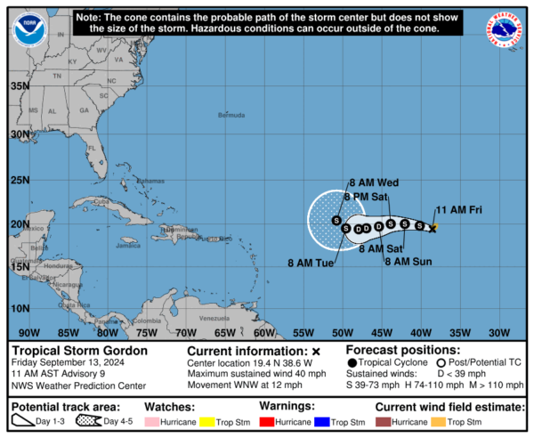
IN THE TROPICS: The NHC is monitoring Tropical Storm Gordon in the eastern Atlantic. The center of Tropical Storm Gordon was located near latitude 19.4 North, longitude 38.6 West. Gordon is moving toward the west-northwest near 12 mph and the storm is expected to move more to the west this weekend and Monday. Maximum sustained winds have increased to near 40 mph with higher gusts. Slight strengthening is expected today before a weakening trend begins on Saturday. Tropical-storm-force winds extend outward up to 70 miles from the center. The estimated minimum central pressure is 1006 mb (29.71 inches).
Also, in the northern Leeward Islands, surface observations indicate a small area of low pressure is located over the northern Leeward Islands. The system continues to produce showers and thunderstorms this morning, but they have not become any better organized. Environmental conditions, including the proximity of dry air, do not favor development of this system while it moves west-northwestward at about 15 mph. Regardless of development, locally heavy rainfall and gusty winds are possible across the northern Leeward Islands today. Formation chance through 7 days…low…20 percent.
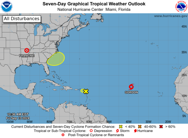
And, offshore the Southeastern U.S., a non-tropical area of low pressure could form along a frontal boundary a few hundred miles off the southeastern U.S. coastline this weekend. Thereafter, some subtropical or tropical development is possible during the early part of next week while the system moves generally northwestward toward the coast. Formation chance through 7 days…low…30 percent.
Next names up are Helen and Isaac.
WORLD TEMPERATURE EXTREMES: Over the last 24 hours, the highest observation outside the U.S. was 117.9F at Kuwait International Airport, Kuwait. The lowest observation was -99.2F at Vostok, Antarctica.
CONTIGUOUS TEMPERATURE EXTREMES: Over the last 24 hours, the highest observation was 106F at numerous locations across Arizona, Texas, and California. The lowest observation was 15F at Peter Sinks, UT.
Category: Alabama's Weather, ALL POSTS, Tropical
About the Author (Author Profile)
Macon, Georgia Television Chief Meteorologist, Birmingham native, and long time Contributor on AlabamaWX. Stormchaser. I did not choose Weather, it chose Me. College Football Fanatic. @Ryan_StinnetSubscribe
If you enjoyed this article, subscribe to receive more just like it.


