Occasional Showers Through Sunday; Drier Next Week
TROPICAL AIR: A deep layer of tropical moisture will remain across Alabama through Sunday, meaning our forecast will highlight occasional showers and thunderstorms through the weekend. There will be good breaks, but when the rain comes it could be heavy. A flash flood watch remains in effect for much of North and East Alabama. Additional rain of 2-4 inches is possible over the northern and eastern counties over the next three days.
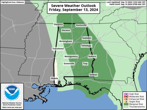
Also, SPC maintains a low end “marginal risk” of a few brief, isolated tornadoes across mainly the eastern half of the state this afternoon and early tonight.
Today instability values will be higher than yesterday, but dynamic support will be much weaker with hardly any meaningful low level helicity. The overall threat is low, but as always we will watch radar trends closely.
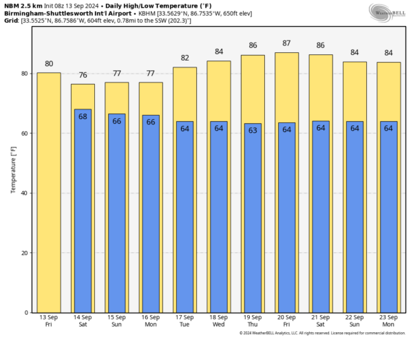
Temperatures will remain in the 70s over North/Central Alabama through Sunday due to clouds and rain; highs will be in the low mid 80s over the southern third of the state.
NEXT WEEK: A few showers remain possible Monday, but the rest of the week looks mostly dry with highs in the 80s. A few isolated showers are possible over far South Alabama Tuesday and Wednesday, but even there rain amounts will be light and spotty. See the video briefing for maps, graphics, and more details.
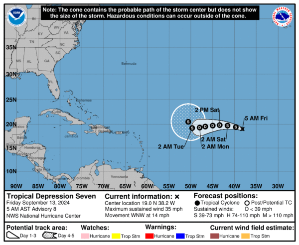
TROPICS: Tropical Depression Seven is in the eastern Atlantic, far from land. All of the global models show the cyclone’s wind field weakening over the weekend, with the GFS suggesting the depression could degenerate into a remnant low. One way or another it will remain far from land.
FOOTBALL WEATHER: Showers are possible for high school football games across Alabama tonight; temperatures will be in the 70s.
Alabama will take on Wisconsin tomorrow in Madison, WI (11:00a CT kickoff)… the sky will be partly sunny with only a small risk of a passing shower during the second half. Temperatures will rise from 77 degrees at kickoff, to near 81 by the final whistle.
UAB plays at Arkansas tomorrow (3:15p CT kickoff)… the sky will be sunny with temperatures in the mid to upper 80s at kickoff, falling into the low 80s by the end of the game.
Auburn hosts New Mexico tomorrow evening at Jordan Hare Stadium (6:00p CT kickoff)… the sky will be mostly cloudy, and some rain is very possible, if not likely, during the game. Temperatures will be in the mid 70s.
ON THIS DATE IN 1988: Hurricane Gilbert smashed into the Cayman Islands, and as it headed for the Yucatan Peninsula of Mexico strengthened into a monster hurricane, packing winds of 175 mph. The barometric pressure at the center of Gilbert reached 888 mb, a record for any hurricane in the Caribbean, Gulf of Mexico, or the Atlantic Ocean until Hurricane Wilma in 2005. Gilbert covered much of the Gulf of Mexico, producing rain as far away as the Florida Keys.
ON THIS DATE IN 2008: Hurricane Ike made landfall as a Category 2 storm near Galveston, Texas.
Look for the next video briefing here by 3:00 this afternoon… enjoy the day!
Category: Alabama's Weather, ALL POSTS, Weather Xtreme Videos


