
A Quick Review of the Tropics: Another Home Grown System Off the Mid-Atlantic?
FRANCINE
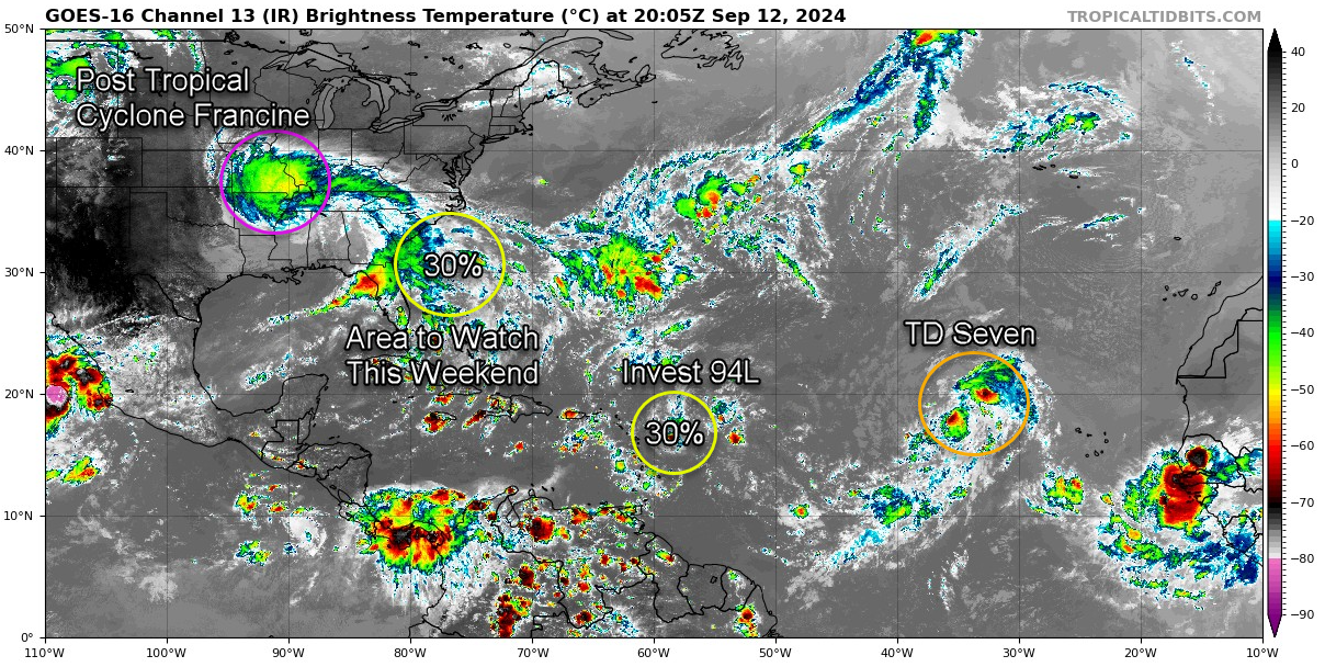
Post-Tropical Cyclone Francine, now located about 90 miles south of Memphis, Tennessee, continues to pose a significant threat to portions of the Southeast despite its transition from a tropical system. With maximum sustained winds of 25 mph, Francine is moving north at 9 mph and is expected to shift northwest while slowing down. Heavy rainfall remains the primary hazard, with storm totals of 4 to 8 inches expected across parts of Mississippi, eastern Arkansas, Tennessee, Alabama, Georgia, and the Florida Panhandle. Some areas, particularly in Alabama, the Florida Panhandle, and Georgia, could see up to 12 inches, leading to considerable flash flooding. The system also brings a risk of isolated tornadoes across the Florida Panhandle, southern and central Alabama, and southwest Georgia, while wind advisories remain in effect for parts of the Southeast. Swells generated by Francine are gradually subsiding but may continue to cause dangerous rip currents along the northern Gulf Coast.
AREA OF INTEREST
An area of interest is being monitored offshore the southeastern U.S. coastline, where a non-tropical low-pressure system could form along a lingering frontal boundary this weekend. While the system is expected to drift north or northwest, subtropical or tropical development is possible early next week. At this time, the chance of formation within the next 48 hours remains near 0 percent, but the potential increases to 30 percent over the next 7 days.
INVEST 94L
Invest 94L, a small area of low pressure located a few hundred miles east of the Leeward Islands, continues to show some signs of organization. However, dry air near the system may limit further development over the next couple of days. Environmental conditions are expected to become less favorable through the weekend as the system moves slowly west-northwestward. Regardless of development, Invest 94L could bring locally heavy rainfall and gusty winds to the northern Leeward Islands on Friday. The National Hurricane Center currently gives the system a 30 percent chance of formation over both the next 48 hours and the next 7 days.
TROPICAL DEPRESSION SEVEN
Tropical Depression Seven is showing signs of organization, with a compact circulation and bursts of deeper convection near its center, although the system has been exposed for parts of the day. Currently maintaining maximum sustained winds of 35 mph, the depression is close to reaching tropical storm status, with conditions somewhat favorable for gradual strengthening. The system is moving west-northwestward and is expected to slow down as the subtropical ridge to its north weakens. While environmental conditions, including low to moderate wind shear and marginally warm sea surface temperatures, support slight intensification, there is uncertainty in the long-range forecast due to varying model guidance. The National Hurricane Center forecasts a peak intensity of 50 mph in five days, though stronger development is possible early next week as the system encounters warmer waters and less shear. The next name on our list is Gordon. The depression is expected to remain a risk only to the open Atlantic in the coming days.
Category: Alabama's Weather, ALL POSTS, Severe Weather, Tropical
About the Author (Author Profile)
Bill Murray is the President of The Weather Factory. He is the site's official weather historian and a weekend forecaster. He also anchors the site's severe weather coverage. Bill Murray is the proud holder of National Weather Association Digital Seal #0001 @wxhistorianSubscribe
If you enjoyed this article, subscribe to receive more just like it.


