
A Firehose of Rain Moving Toward Birmingham and the I-65 Corridor: 1.5 Inches Per Hour Possible, May Cause Flooding
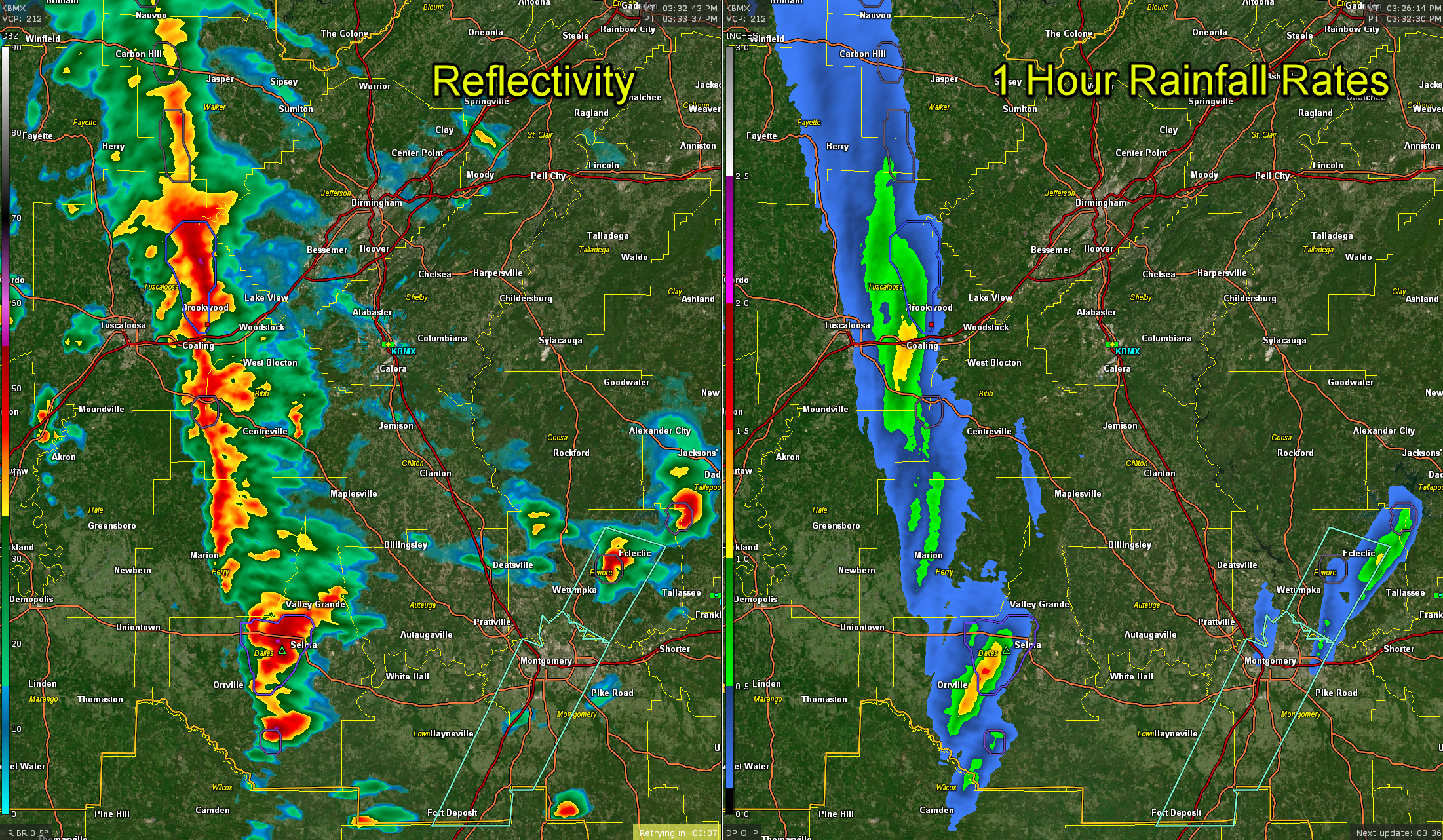
A very narrow firehose of precipitation in the form of a 6-8 mile wide band of very heavy rain is pushing east northeast across Central Alabama this afternoon and southern Winston and Walker Counties through Tuscaloosa County (it is past the City of Tuscaloosa), western Bibb County, Perry, and into Dallas County.
Some of the heaviest precipitation is over southeastern Tuscaloosa County. It will be moving into southern Jefferson, Bibb, and western Shelby counties.
To the south, very intense rainfall is over Dallas County approaching Selma.
The line is pushing eastward as 10-12 mph. It will reach western portions of the Birmingham Metro area around 445 pm. It will hose down the entire metro between then and 7 p.m. Expect 1-1.5 inches of rain. Rainfall duration should be 45 mins to one hour. This is not good news for rush hour.
Rainfall rates are approaching 1.5 inches per hour in the Tuscaloosa/Dallas counties echoes. This could lead to flash flooding. So far, rainfall amounts have been generally light. 0.30″ at the Birmingham Airport. 0.35″ inches here near Acton Road.
Across South Central ALabama, flood advisories continues for Elmore, Lowndes, and Montgomery Counties. They will all expire by 530 p.m. Rainfall has diminished in those areas.
These storms are not severe, but the low level helicity is very strong (around 249 m2/s2) over Tuscaloosa County, so we will be vigilant in case any small spin ups develop.
The storm approaching Selma is not as big a threat, as its storm relative helicity is lower, at about 165 m2/s2.
But these severe weather threat could ramp up as the storms approach as cross I-65 into the eastern half of Alabama. Spin up tornadoes will be the threat. They won’t last long and they could hit very quick, so be alert.
But so far, things are calm, except for the rain and the wind. Wind advisories are in effect for all of Central and North Alabama. Winds just gusted to 39 mph at the Birmingham Airport. Winds gusted to 40 mph at Anniston. There have been numerous reports of trees down across North and Central Alabama.
Category: Alabama's Weather, ALL POSTS, Severe Weather
About the Author (Author Profile)
Bill Murray is the President of The Weather Factory. He is the site's official weather historian and a weekend forecaster. He also anchors the site's severe weather coverage. Bill Murray is the proud holder of National Weather Association Digital Seal #0001 @wxhistorianSubscribe
If you enjoyed this article, subscribe to receive more just like it.


