Wet, Windy Day For Alabama; A Few Brief Tornadoes Are Possible
WINDY, WET DAY AHEAD: Rain is widespread across Alabama this morning as Francine moves up into South Mississippi as a weakening tropical low. Here are the weather issues today…
WIND: A wind advisory is in effect for most of Alabama today. Gradients winds will hit 30/40 mph at times, with the higher gusts over the western half of the state.
RAIN: A flash flood watch is in effect for much of Alabama; rain amounts through tomorrow night will be in the 2-4 inch range for most communities, but model data suggests totals could exceed four inches over parts of North Alabama as the remnant circulation of Francine stalls near Memphis. We note the heaviest rain is mostly over for the Alabama Gulf Coast, and the rain will taper off along the Florida coast later today.
Understand there will be breaks in the rain, but occasional showers and a few thunderstorms are likely through tomorrow, with potential for heavy rain at times.
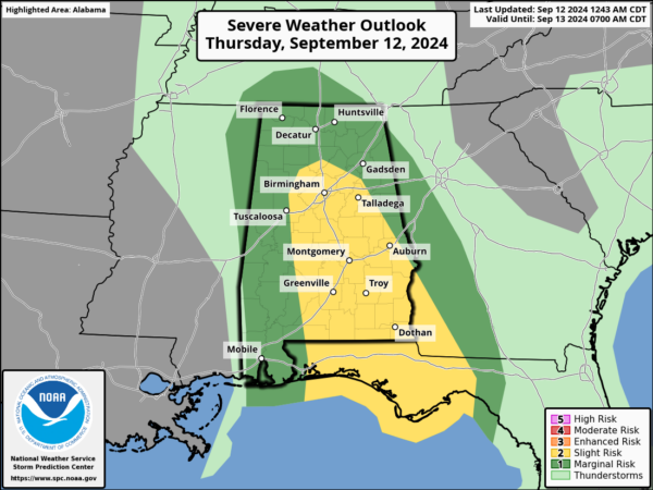
TORNADOES: A few, brief isolated tornadoes are possible later today and early tonight across Alabama. SPC maintains a “slight risk” (level 2/5) from near Birmingham south to Andalusia and Dothan… a “marginal risk” (level 1/5) covers the rest of the state.
If the sufficient instability can develop, a tornado or two can’t be ruled out. The main window comes from about 10:00 this morning through 8:00 tonight. Remember, tornadoes produced by a tropical system are typically short lived and on the low end of the EF scale, but they are still dangerous and we will be watching radar trends closely.
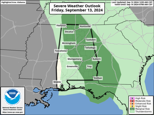
We also note SPC maintains a low end “marginal risk” (level 1/5) tomorrow over much of North and East Alabama, again for the potential for a few brief, isolated tornadoes.
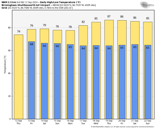
THE ALABAMA WEEKEND: The weather will remain unsettled with scattered to numerous showers and thunderstorms both Saturday and Sunday. Not a total wash-out, but if you have something planned outdoors expect some rain at times with highs in the 77-82 degree range. Only a limited amount of sun.
NEXT WEEK: Showers and storms remain possible Monday and Tuesday, but the weather trends much drier over the latter half of the week as a north flow develops across the Deep South. See the video briefing for maps, graphics, and more details.
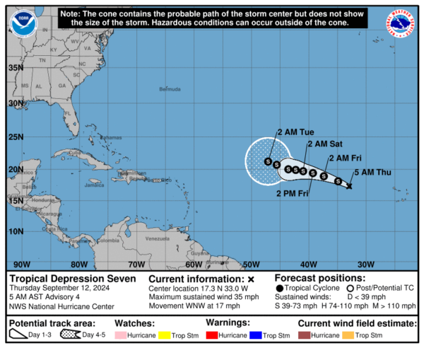
TROPICS: Tropical Depression Seven is in the eastern Atlantic this morning; it will remain far from land with only a slow motion to the west over the next five days. Most global models suggest this system will turn north into the open Atlantic.
FOOTBALL WEATHER: Showers are possible for high school football games across Alabama tomorrow night; temperatures will be in the 70s.
Alabama will take on Wisconsin Saturday in Madison, WI (11:00a CT kickoff)… the sky will be mostly cloudy with only a small risk of a passing shower during the game. Temperatures will rise from 77 degrees at kickoff, to near 81 by the final whistle.
UAB plays at Arkansas Saturday (3:15p CT kickoff)… the sky will be sunny with temperatures in the mid to upper 80s at kickoff, falling into the low 80s by the end of the game.
Auburn hosts New Mexico Saturday evening at Jordan Hare Stadium (6:00p CT kickoff)… the sky will be mostly cloudy, and we can’t rule out some rain during the game. Temperatures will be in the mid 70s.
ON THIS DATE IN 1979: Frederic made landfall on the Alabama Gulf Coast passing over Dauphin Island and crossed the coastline near the Alabama/Mississippi border. A wind gust of 145 miles per hour was measured on equipment atop the Dauphin Island Bridge. The bridge was destroyed. A wind gust of 139 mph was measured at the Dauphin Island Sea Lab before the equipment failed. A storm surge of 12 feet was observed in Gulf Shores. Nearly all structures within 200 yards of the Alabama coast were destroyed. Total damages were 2.3 billion dollars, making Frederic the most expensive hurricane ever to strike the United States up to that point.
Look for the next video briefing here by 3:00 this afternoon… enjoy the day!
Category: Alabama's Weather, ALL POSTS, Weather Xtreme Videos


