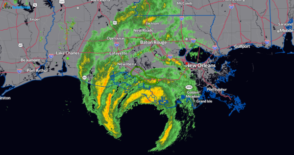
3pm Update: The Eyewall of Francine Closing In on the Louisiana Coast
Here is the latest position update from the NHC. The center is now only 60 miles SSW of Morgan City. An oil platform east of the center recently reported sustained winds of 74 mph and a peak gust of 92 mph at an elevation of 102 ft.
LOCATION…28.9N 91.5W
ABOUT 60 MI…95 KM SSW OF MORGAN CITY LOUISIANA
ABOUT 115 MI…185 KM SW OF NEW ORLEANS LOUISIANA
MAXIMUM SUSTAINED WINDS…90 MPH…150 KM/H
PRESENT MOVEMENT…NE OR 40 DEGREES AT 17 MPH…27 KM/H
MINIMUM CENTRAL PRESSURE…975 MB…28.79 INCHES
The first of what may be many flash flood warnings has been issued by the NWS Lake Charles for St. Mary Parish. This is where the center of Francine is poised to pull in. Between 2-4 inches of rain has already fallen and another 1-3 inches IN AN HOUR a possibility. Flash flooding expected. This would impact places like Morgan City, Franklin, Patterson, Amelia and Centerville.


