Midday Nowcast: Francine Approaching the Coast, with Impacts Ahead for Alabama
BIRMINGHAM ALMANAC: For September 11th, the average high for Birmingham is 87° and the average low is 67°. The record high is 98° set in 2010, while the record low is 47° set in 1976. We average 0.14” of precipitation on this date, and the record value is 1.69” set in 2017.
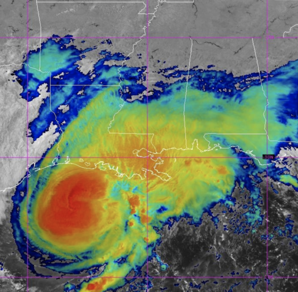
LATEST ON FRANCINE: The center of Hurricane Francine was located near latitude 28.0 North, longitude 92.7 West. Francine is moving toward the northeast near 13 mph. A faster northeastward motion is expected this afternoon, and Francine is anticipated to make landfall in Louisiana within the warning area late this afternoon or this evening. After landfall, the center is expected to cross southeastern Louisiana tonight, then move northward across Mississippi on Thursday and Thursday night.
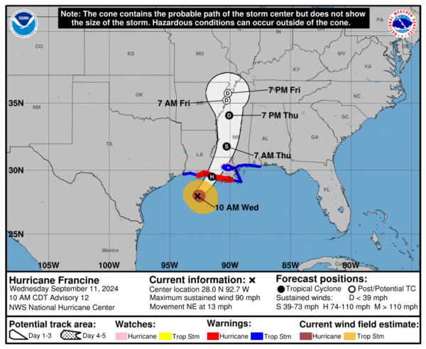
Reports from Air Force Reserve and NOAA Hurricane hunter aircraft indicate that maximum sustained winds are near 90 mph with higher gusts. Little change in strength is expected before landfall. Francine is expected to rapidly weaken after landfall, and the system is forecast to become post-tropical on Thursday.
Hurricane-force winds extend outward up to 40 miles from the center and tropical-storm-force winds extend outward up to 115 miles. An oil platform north of the center recently reported sustained winds of 87 mph and a peak gust of 105 mph at an elevation of 98 ft. The minimum central pressure based on the Hurricane Hunter aircraft data is 976 mb (28.82 inches). An oil platform located east of the center recently reported a pressure of 978.7 mb (28.90 inches).
ALABAMA IMPACTS: Alabama will be on the wet, unsettled east side of the system. A tropical storm warning remains in effect for the Alabama Gulf Coast. A storm surge of 2-4 feet is forecast for the Gulf Coast of Mobile and Baldwin counties, and Mobile Bay as well.
GRADIENT WIND: As the storms moves inland winds could gust as high as 50/55 mph along the Alabama Gulf Coast late this afternoon and tonight. For inland parts of Alabama, gusts to 35/40 mph are possible tomorrow as the circulation of Francine moves northward through Mississippi. A wind advisory will most likely be needed. These winds would certainly cause tree and power issues as the storm moves inland.
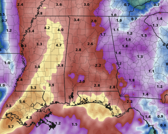
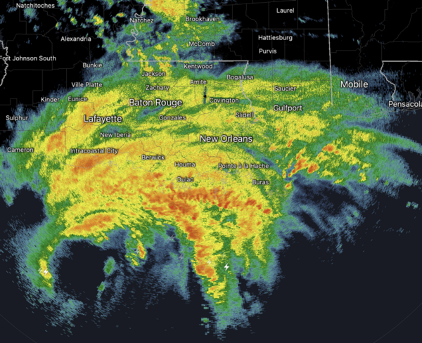
RAIN: Rain amounts over Mobile and Baldwin counties will be in the 2-4 inch range, with amounts between 1-3 inches for the rest of the state. Heavier totals will likely be over the western counties. A flash flood watch is in effect for Mobile, Baldwin, and Washington counties in Southwest Alabama.
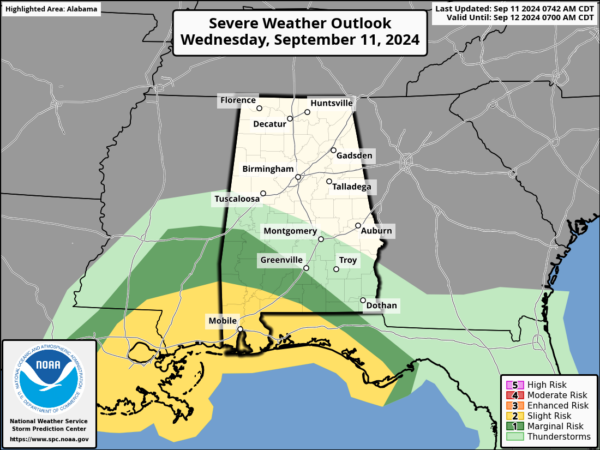
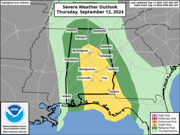
TORNADOES: A few brief, isolated tornadoes can’t be ruled out across the state; SPC has defined a “slight risk” (level 2/5) of severe thunderstorms for the southwest counties of Alabama late today and tonight. Then, tomorrow there is a “slight risk” (level 2/5) for a broad zone from Birmingham to Montgomery to Dothan. The rest of the state is in a “marginal risk” (level 1/5).
Remember, tropical tornadoes are very short-lived, and many times are just rotating showers. This makes it very difficult to provide a warning with a long lead time, so be very weather aware tonight and tomorrow and pay attention to warnings.
The weather will improve along the Gulf Coast during the day tomorrow as Francine moves northward. However, a high rip current danger will be in place across the Central Gulf Coast through Friday.
END OF WEEK: The remnant circulation of Francine will likely stall northwest of Alabama, and this means some risk of scattered showers and thunderstorms on a daily basis Friday through Sunday. This won’t be a continuous rain, and the sun will be out at times, but just understand some rain is likely at times. Highs will be in the low to mid 80s. Some risk of scattered showers and storms will likely continue through at least the first half of the week; highs remain in the 80s.
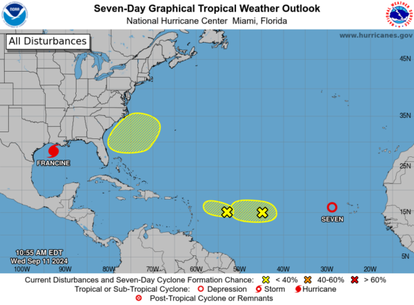
ELSEWHERE IN THE TROPICS: There are multiple areas the NHC is monitoring, and one of those is now Tropical Depression Seven and should become Gordon in the coming days. The center of Tropical Depression Seven was located near latitude 16.0 North, longitude 28.7 West. The depression is moving toward the west-northwest near 18 mph, and a west to west-northwest motion at a slower forward speed is anticipated over the next few days. Maximum sustained winds are near 35 mph with higher gusts. Some strengthening is forecast during the next 48 hours, and the depression could become a tropical storm tonight or on Thursday. The estimated minimum central pressure is 1007 mb (29.74 inches).

WORLD TEMPERATURE EXTREMES: Over the last 24 hours, the highest observation outside the U.S. was 122.0F at Nasiriya, Iraq. The lowest observation was -99.9F at Concordia, Antarctica.
CONTIGUOUS TEMPERATURE EXTREMES: Over the last 24 hours, the highest observation was 115F at Death Valley, CA. The lowest observation was 27F at Stanley, ID.
Category: Alabama's Weather, ALL POSTS, Tropical
About the Author (Author Profile)
Macon, Georgia Television Chief Meteorologist, Birmingham native, and long time Contributor on AlabamaWX. Stormchaser. I did not choose Weather, it chose Me. College Football Fanatic. @Ryan_StinnetSubscribe
If you enjoyed this article, subscribe to receive more just like it.


