Midday Nowcast: All Eyes on Francine
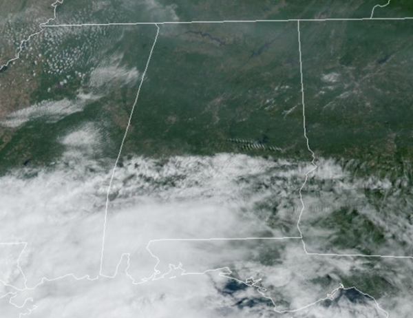
REST OF TODAY: It is generally sunny day for most of Alabama with a highs around 90° for most locations across the state. If there are any showers, they are confined to the far southern counties of the state.
BIRMINGHAM ALMANAC: For September 10th, the average high for Birmingham is 87° and the average low is 67°. The record high is 99° set in 1980, while the record low is 49° set in 1969. We average 0.15” of precipitation on this date, and the record value is 1.53” set in 1907.
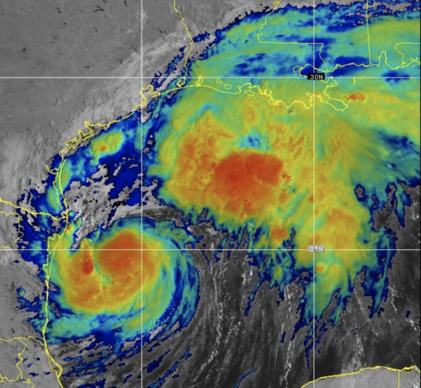
ALL EYES ON FRANCINE: Latest update from the NHC, the center of Tropical Storm Francine was located near latitude 24.9 North, longitude 95.6 West. Francine is moving toward the north-northeast near 8 mph. A turn to the northeast with an increase in forward speed is expected later today or tonight. On the forecast track, Francine is anticipated to be just offshore of the coasts of northeastern Mexico and southern Texas through this afternoon, and then move across the northwestern Gulf of Mexico, making landfall in Louisiana on Wednesday. After landfall, the center is expected to move into Mississippi on Wednesday night or Thursday.
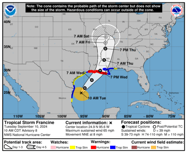
Maximum sustained winds are near 65 mph with higher gusts. Strengthening is expected through Wednesday morning, and Francine will likely become a hurricane later today or tonight. Francine is expected to weaken quickly after landfall. Tropical-storm-force winds extend outward up to 140 miles from the center. The minimum central pressure reported by NOAA and Air Force Reserve Hurricane Hunter aircraft is 988 mb (29.18 inches).
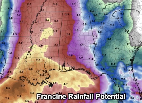
FRANCINE ALABAMA IMPACTS: Clouds increase tonight ahead of Francine, and rain will expand northward across Alabama during the day tomorrow. Tomorrow night and Thursday will be breezy with periods of rain and a few thunderstorms as our state will be on the east/wet side of the circulation.
Gradient winds could gust as high as 50 mph along the Alabama Gulf Coast late tomorrow and tomorrow night; gusts to 35 mph are possible for the northern half of the state on Thursday. Rain amounts over Mobile and Baldwin counties will be in the 2-4 inch range, with amounts between 1-3 inches for the rest of the state. Heavier totals will likely be over the western counties.
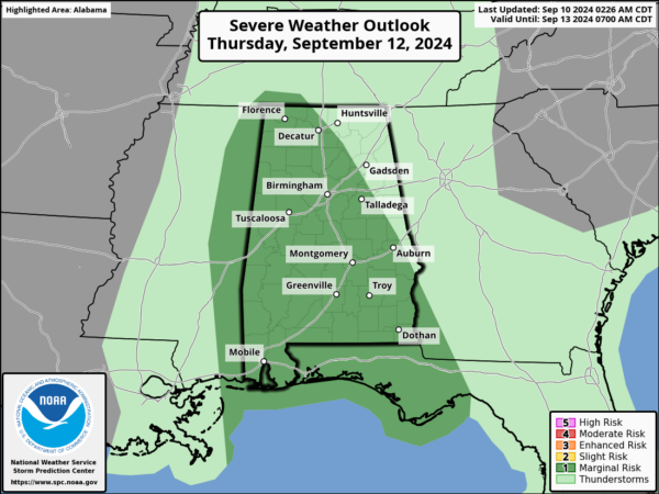
A few brief, isolated tornadoes can’t be ruled out across the state, since we are east of the center of circulation, and the SPC has defined is in a “marginal risk” (level 1/5) during the day Thursday for a low-end tornado threat. Remember, tropical tornadoes are very short-lived, and many times are just rotating showers. Just make sure you have multiple ways to alerts, and be prepared to take quick action, as tropical tornadoes occur with little to now warning.
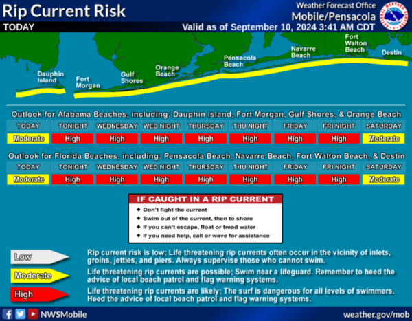
The weather will improve along the Gulf Coast during the day Thursday as Francine moves northward. However, a high rip current danger will be in place across the Central Gulf Coast through Friday.
END OF WEEK: The remnant circulation of Francine will likely stall northwest of Alabama, and this means some risk of scattered showers and thunderstorms on a daily basis Friday through Sunday. This won’t be a continuous rain, and the sun will be out at times, but just understand some rain is likely at times. Highs will be in the low to mid 80s. Some risk of scattered showers and storms will likely continue through at least the first half of the week; highs remain in the 80s.
ELSEWHERE IN THE TROPICS: In the Central Tropical Atlantic (AL92), an elongated area of low pressure located over the central tropical Atlantic continues to produce some disorganized shower and thunderstorm activity. Environmental conditions appear only marginally conducive for some slight development during the next couple of days, but a tropical depression could still form during that time while the system moves westward at 5 to 10 mph over the central tropical Atlantic. Formation chance through 7 days…medium…40 percent.
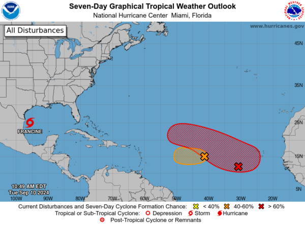
In the Eastern and Central Tropical Atlantic, a trough of low pressure located several hundred miles southwest of the Cabo Verde Islands is expected to interact and merge with a strong tropical wave located between the west coast of Africa and the Cabo Verde Islands over the next couple of days. Thereafter, Environmental conditions appear favorable for gradual development of this combined system, and a tropical depression will likely form during the latter part of this week while the system moves west-northwestward at 10 to 15 mph. Formation chance through 7 days…high…70 percent.
Next names up are Gordon and Helen.
WORLD TEMPERATURE EXTREMES: Over the last 24 hours, the highest observation outside the U.S. was 120.4F at Nasiriya, Iraq. The lowest observation was -101.9F at Concordia, Antarctica.
CONTIGUOUS TEMPERATURE EXTREMES: Over the last 24 hours, the highest observation was 117F at Death Valley, CA. The lowest observation was 22F at Davis, WV.
Category: Alabama's Weather, ALL POSTS
About the Author (Author Profile)
Macon, Georgia Television Chief Meteorologist, Birmingham native, and long time Contributor on AlabamaWX. Stormchaser. I did not choose Weather, it chose Me. College Football Fanatic. @Ryan_StinnetSubscribe
If you enjoyed this article, subscribe to receive more just like it.


