Francine Makes Landfall Tomorrow; Tropical Rain Ahead For Alabama
ONE MORE MOSTLY DRY DAY: Most of Alabama will stay dry today with a partly sunny sky. Cloud coverage will be higher over the southern third of the state, and showers remain possible near the coast. Highs today will be in the 85-90 degree range for most communities.
Clouds increase tonight ahead of the tropical system in the Gulf (Francine), and rain will expand northward across Alabama during the day tomorrow. Tomorrow night and Thursday will be breezy with periods of rain and a few thunderstorms as our state will be on the east/wet side of the circulation.
More about the impact for Alabama tomorrow night and Thursday:
*Gradient winds could gust as high as 50 mph along the Alabama Gulf Coast late tomorrow and tomorrow night; gusts to 35 mph are possible for the northern half of the state on Thursday.
*Rain amounts over Mobile and Baldwin counties will be in the 2-4 inch range, with amounts between 1-3 inches for the rest of the state. Heavier totals will likely be over the western counties.
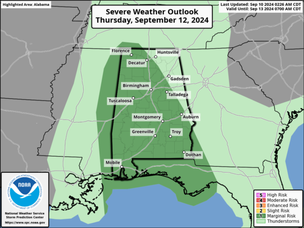
*A few brief, isolated tornadoes can’t be ruled out across the state; SPC has defined a “slight risk” (level 2/5) of severe thunderstorms for Mobile and Baldwin counties tomorrow night, and most of the state (with the exception of the northeast counties) is in a “marginal risk” (level 1/5) during the day Thursday.
*The weather will improve along the Gulf Coast during the day Thursday as Francine moves northward. However, a high rip current danger will be in place across the Central Gulf Coast through Friday.
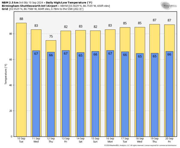
FRIDAY AND THE WEEKEND: The remnant circulation of Francine will likely stall northwest of Alabama, and this means some risk of scattered showers and thunderstorms on a daily basis Friday through Sunday. This won’t be a continuous rain, and the sun will be out at times, but just understand some rain is likely at times. Highs will be in the low to mid 80s.
NEXT WEEK: Some risk of scattered showers and storms will likely continue through at least the first half of the week; highs remain in the 80s. See the video briefing for maps, graphics, and more details.
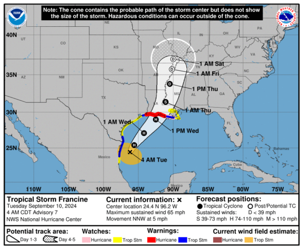
FRANCINE: Tropical Storm Francine is still producing sustained winds of 65 mph early this morning. The center is about 415 miles south/southwest of Cameron, LA, and the system is moving to the north/northwest at only 5 mph. While the system didn’t get better organized overnight, NHC still is forecast hurricane strength later today.
The tropical cyclone should be over very warm waters before landfall, although west-southwesterly vertical wind shear over the system is likely to increase. The latter environmental influence will probably limit Francine’s strengthening. NHC is still forecasting Francine to be a category two hurricane at the time of landfall tomorrow evening on the central Louisiana coast. We note the official intensity forecast is now at the high end of the model guidance.
A Hurricane Warning remains in effect for the Louisiana coast from Sabine Pass eastward to Morgan City.
NHC is also monitoring two waves in the central and eastern Atlantic with potential for development; it remains to be seen if they will impact any land areas.
ON THIS DATE IN 2017: Hurricane Irma made landfall on Cudjoe Key, Florida as a category four storm with winds of 130 mph. It was the most intense hurricane to strike the continental United States since Katrina in 2005, the first major hurricane to make landfall in Florida since Wilma in the same year, and the first Category 4 hurricane to strike the state since Charley in 2004. The hurricane caused at least 134 deaths, and caused widespread and catastrophic damage throughout its long lifetime, particularly in the northeastern Caribbean and the Florida Keys.
Look for the next video briefing here by 3:00 this afternoon… enjoy the day!
Category: Alabama's Weather, ALL POSTS, Weather Xtreme Videos


