Francine Update: New Warnings for the Louisiana Coast; Could Become a Cat 2
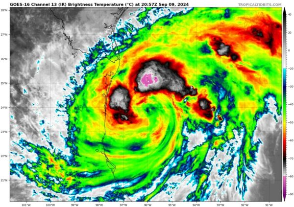
We have the latest from the NHC from their comprehensive 4pm CT update. One of the main takeaways from this update is the signs now of rapid intensification and the NHC forecast now states Francine could be a Cat 2 hurricane at landfall. Let’s start with the latest stats:
LOCATION…24.0N 96.0W
ABOUT 150 MI…245 KM SSE OF MOUTH OF THE RIO GRANDE
ABOUT 435 MI…700 KM SSW OF CAMERON LOUISIANA
MAXIMUM SUSTAINED WINDS…65 MPH…100 KM/H
PRESENT MOVEMENT…NNW OR 340 DEGREES AT 7 MPH…11 KM/H
MINIMUM CENTRAL PRESSURE…996 MB…29.42 INCHES
Pressure was left alone but the winds are now up to 65 mph! The NHC discussion mentions the eyewall feature on the Brownsville radar we pointed out in an earlier update. Over the past few hours, the appearance of Francine has become more impressive.
There could be three hurricane hunter planes in Francine this evening. Jeremy DeHart, Meteorologist and Hurricane Hunter, posted on X the recon plan for the next 48 hours. So thankful for these crews getting the very important data needed on these systems!
Heavy recon plan for #Francine for the next 48 hrs. With NOAA 49 already in the air and both NOAA 43 & TEAL 73 expected to takeoff in the next hr, should have 3 planes in the storm this evening. Then 3-hourly fix requirements starting Tue evening thru landfall. pic.twitter.com/OOkQr2nYT2
— Jeremy DeHart (@JeremyDeHart53d) September 9, 2024
Here is the updated list of watches and warnings and there are quite a few additions. There are new storm surge warnings and hurricane warnings for parts of the Texas and Louisiana coast.
A Storm Surge Warning is in effect for…
* High Island Texas to the Mouth of the Mississippi River Louisiana
* Vermilion Bay
A Hurricane Warning is in effect for…
* The Louisiana coast from Sabine Pass eastward to Morgan City
A Storm Surge Watch is in effect for…
* Mouth of the Mississippi River Louisiana to the
Mississippi/Alabama Border
* Lake Maurepas
* Lake Pontchartrain
A Hurricane Watch is in effect for…
* The Louisiana coast from Morgan City eastward to Grand Isle
A Tropical Storm Warning is in effect for…
* Morgan City to Grand Isle
* High Island to Sabine Pass
A Tropical Storm Watch is in effect for…
* Barra del Tordo to the Mouth of the Rio Grande
* Mouth of the Rio Grande to High Island Texas
* East of Grand Isle Louisiana to Mouth of the Pearl River,
including metropolitan New Orleans
* Lake Pontchartrain
* Lake Maurepas
A mandatory evacuation has been ordered for the southern parts of Cameron Parish, LA. This includes the communities of Jackberry, Johnson Bayou, Holly Beach, Cameron, Creole, Grand Chenier and Big Lake. This will be the start of what will be more voluntary and mandatory evacuation orders from area officials as Francine makes its way toward the coast.
BREAKING…MANDATORY EVACUATION ORDER FOR PORTIONS OF CAMERON PARISH ISSUED #lawx #Francine pic.twitter.com/Cx7m3LN6UA
— Rob Perillo (@robperillo) September 9, 2024
There were signs earlier of possible rapid intensification and the NHC discusses that at length. In general, with an inner-core now forming with Francine and a movement into a highly conducive atmosphere for strengthening (low wind shear, plenty of moisture, warm waters), quick intensification is forecast and Francine could be a Category 2 storm at landfall along the Louisiana Coast.
All efforts to protect life and property in the watch and warnings areas needs to happen immediately. The worst of Francine will be heading into southern Louisiana on Wednesday.


