Focus on Francine’s Forecast: New Iberia LA
New Iberia is located along US-90 between Lafayette and New Orleans in Louisiana. It is about 10 miles north of Vermillion Bay.
If the NHC track forecast is correct, the center of Francine will pass near New Iberia Wednesday evening. Here is the forecast based on this track and current thoughts on intensity, allowing for some additional intensification.
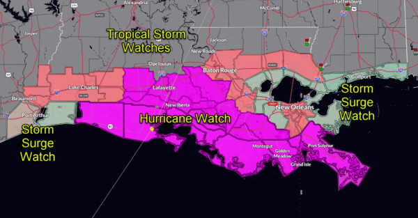
CURRENT WATCHES AND WARNINGS
Hurricane Watch in effect, meaning hurricane-force winds are possible within the next 48 hours.
Storm Surge Watch in effect, meaning life-threatening inundation from rising water is possible within the next 48 hours.
WINDS
Tropical storm force winds are expected to begin Wednesday morning around 7 AM CDT and continue until Thursday morning around 2 AM CDT. Hurricane-force winds are likely to start in the early afternoon around 1 PM CDT, lasting through the evening. Peak winds could reach 75-95 mph, with gusts up to 110 mph, leading to significant damage including roof failures, uprooted trees, and widespread power outages. Roads may become hazardous or blocked by large debris, so preparations should be completed before these dangerous winds arrive.
STORM SURGE
Storm surge of 1-3 feet above ground is expected, particularly in coastal and low-lying areas near Vermilion Bay, Marsh Island, and the communities of Lydia and Cypremort Point. The surge, along with high waves, could cause localized flooding, damage to marinas, and erosion along shorelines. Low-lying roads near these coastal areas could become flooded and impassable during the height of the storm. The map shows SLOSH data for a category three hurricane. Areas in lighter blue could experience rising water. Areas in darker blue could actually see inundation, especially along LA-14 west and south of New Iberia.
The NHC is forecasting 5-10 feet of storm surge in Vermillion Bay.
RAINFALL
Rainfall totals of 4 to 8 inches are expected, with locally higher amounts possible. This heavy rain may lead to flash flooding in flood-prone areas, with some streets and low-lying areas likely to become inundated. Rivers and creeks could overflow their banks, causing hazardous travel conditions and significant flooding in both urban and rural areas.
STORM DURATION
The duration of the storm’s most intense impacts is expected from early Wednesday morning through late Wednesday evening, with conditions improving by Thursday morning.
UNCERTAINTY
Of course, the forecast cone 48 hours before landfall could mean the center could end up anywhere from Port Arthur and New Orleans, so any community in the cone could experience these same peak impacts as New Iberia, so keep that in mind.
Category: Alabama's Weather, Tropical


