Disturbance Becomes Francine! Numerous Advisories for Parts of the Gulf Coast.
It is going to be a very active week monitoring the tropics and impacts for the Gulf Coast and eventually for Alabama. We will have updates throughout the event.
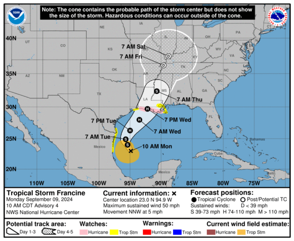
We now have Tropical Storm Francine. The NHC has produced the 10am CDT advisory. Breaking down the details in this post on the current conditions with Francine, where the storm may be going, possible Alabama impacts and what else may be brewing in the Atlantic.
10am CDT Stats:
LOCATION…23.0N 94.9W
ABOUT 245 MI…395 KM SE OF MOUTH OF THE RIO GRANDE
ABOUT 480 MI…770 KM SSW OF CAMERON LOUISIANA
MAXIMUM SUSTAINED WINDS…50 MPH…85 KM/H
PRESENT MOVEMENT…NNW OR 340 DEGREES AT 5 MPH…7 KM/H
MINIMUM CENTRAL PRESSURE…1002 MB…29.59 INCHES
Current Watches and Warnings:
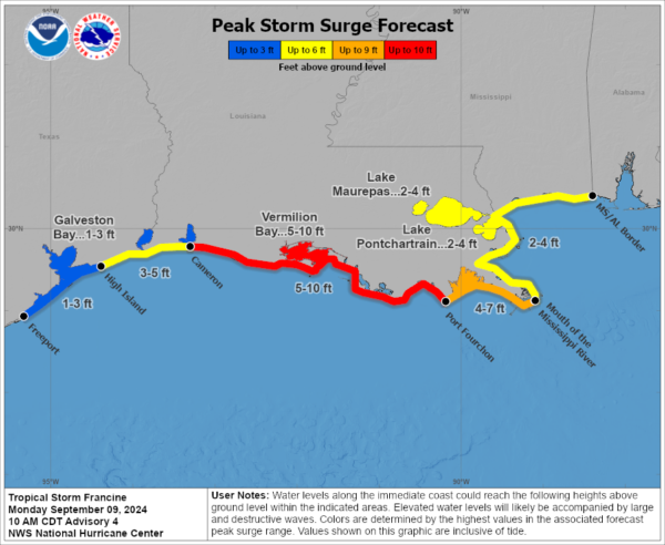
A Storm Surge Watch is in effect for…
* High Island Texas to the Mississippi/Alabama Border
* Vermilion Bay
* Lake Maurepas
* Lake Pontchartrain
A Hurricane Watch in in effect for…
* The Louisiana coast from Cameron eastward to Grand Isle
A Tropical Storm Watch is in effect for…
* Barra del Tordo to the Mouth of the Rio Grande
* Mouth of the Rio Grande to Port Mansfield
* East of High Island Texas to Cameron Louisiana
* West of Grand Isle to Mouth of the Pearl River
* Lake Pontchartrain
* Lake Maurepas
The Future of Francine:
Francine is still moving to the north-northwest around 5 mph. It will continue to trek this way for the remainder of today and then speed up on Tuesday. By Wednesday late day, Francine is poised to pull into the Louisiana coastline as a hurricane! Something to watch closely is the possibility of a period of rapid intensification with Francine. The NHC discussion does suggest this: “While the system is now a tropical storm, the inner core wind field per reconnaissance observations is still broad and in the organizing stage, and initial intensification will be gradual. However, after an inner-core becomes established, and assuming the cyclone’s vertical structure becomes aligned, a period of more significant intensification is possible while storm is embedded in a low shear, high mid-level moisture, and over very warm 30-31 C sea-surface temperatures. The SHIPS rapid intensification (RI) indices are pretty elevated, and a period of RI could also occur between 24-48
h.”
There are still uncertainties on where the center will make landfall and how strong Francine could become between now and then. Little shifts in direction and of course intensity will have a big impact on who could received the highest surge and highest amounts of coastal flooding.
Projected storm surge of 5-10 feet currently forecast from Cameron, LA to Port Fourchon, LA and Vermilion Bay.
In terms of rain amounts: 4-8 inches of rain with locally up to a foot for parts of the TX, LA and MS Coasts.
What about Alabama?
Based on the latest track, the center of Francine will pull inland and be in west central MS by Thursday morning. It will then work north into more of the TN Valley. A big push of tropical moisture will come into the state and we are expecting periods of heavy rain at times. Isolated flash flooding could occur. 2-3 inches of rain possible esp along and west of I-65 during the Wed Night to Friday timeframe. This is good news for the increasing drought!
Still a little too early to say for sure, but as with any landfalling tropical system, there may be small tornado threat that develops. That will be monitored as well.
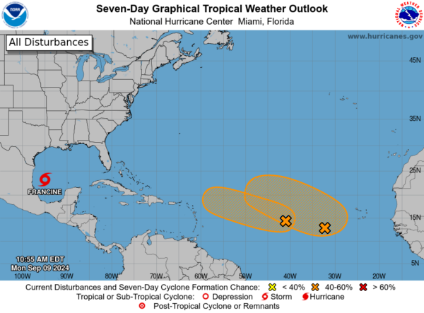
Rest of the Tropics:
There are two other disturbances in the Atlantic. Both have the possibility of developing further into tropical depressions. We will monitor those as well!


