Midday Nowcast: Rain for Some, Clouds for All
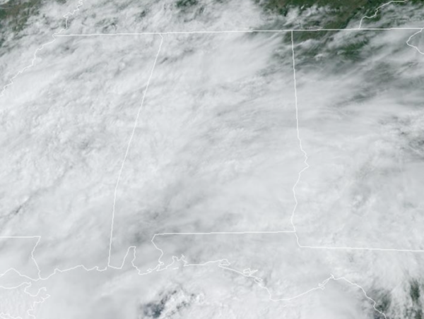
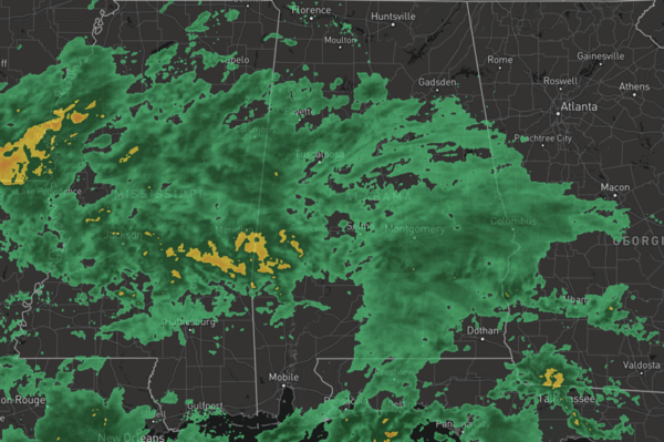
A low pressure is tracking east along the Northern Gulf Coast and will keep us cloudy today with periods of rain today and tonight. The more widespread and heavier rainfall will be over the southern half of the state, where rainfall totals over an inch are likely.
For areas in North Alabama, little to no rain is likely, for areas in Central Alabama; Birmingham, Tuscaloosa, and Anniston, rainfall totals less than one-half are expected. There is no threat of severe weather with this system, and likely no thunder will occur. Due to the clouds and rain, highs today are in the upper 70s and low 80s.
FRIDAY NIGHT LIGHTS: For high school games across the state tonight, some light rain is possible over the southern 2/3 of the state. Not expecting any lightning, however, and temperatures will be in the 70s.
BIRMINGHAM ALMANAC: For September 6th, the average high for Birmingham is 88° and the average low is 68°. The record high is 106° set in 1925, while the record low is 52° set in 1984. We average 0.13” of precipitation on this date, and the record value is 3.32” set in 1977.
ACROSS THE USA: Heavy to excessive rainfall will continue along the Gulf Coast through Friday. A Moderate Risk of Excessive Rainfall is outlooked over southeast Louisiana where scattered to numerous instances of flash flooding is likely. In the Western U.S., a late summer heatwave will continue through the weekend. Widespread Excessive Heat Warnings and Heat Advisories are in effect.
WEEKEND WEATHER: A drier airmass will push into the state with a front tomorrow. As the front moves through, we can’t rule out a few showers, but the better chance for those will come over southern counties of the state. Tomorrow will be partly sunny with highs in the low 80s. Sunday morning will be refreshing with widespread 50s, and the day will feature a mostly sunny sky with highs in the low to mid 80s.
FOOTBALL WEATHER: Tomorrow Auburn will host California at Jordan-hare Stadium (2:30p CT kickoff)… the sky will be partly sunny, and a brief shower can’t be ruled out. Temperatures will hover in the low to mid 80s during the game.
Alabama will host South Florida tomorrow evening in Tuscaloosa (6:00p CT kickoff)… the sky will be mostly clear with temperatures falling from the low 80s at kickoff, into the upper 60s by the final whistle.
UAB will be on the road; they take on Louisiana-Monroe tomorrow evening (6:00p CT kickoff). The sky will be clear with about 83 degree at kickoff; temperatures drop to near 70 degrees by the fourth quarter.
NEXT WEEK: The weather will be generally rain-free Monday through Wednesday, although a few showers will remain possible near the Gulf Coast and across far South Alabama. There is some potential for increasing rain chances statewide by Thursday and Friday with a weak low approaching from the south, but model output is very inconsistent and forecast confidence is low. Highs will be in the 80s and lows in the 60s through the week.
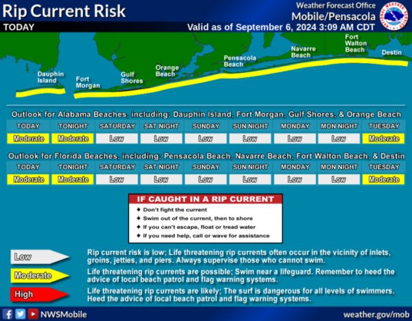
AT THE BEACH: It is going to be rather wet and unsettled in the coming days along the Gulf Coast. Clouds and rain will hold temperatures in the 70s and 80s, with little sunshine in the forecast. Rip current threats are moderate, please pay attention to the Rip Current Flag Warning System at each beach as conditions can change through out the day.
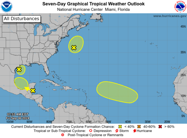
IN THE TROPICS: We now have four areas the NHC is monitoring for potential development, but as of now, all four have a low chance of development.
1. Northwestern Gulf of Mexico (AL90), showers and thunderstorms associated with a low pressure system and weak frontal boundary over the northwestern Gulf of Mexico remain disorganized. Upper-level winds are expected to remain unfavorable for significant development of this system while it meanders over the northwestern Gulf and eventually merges with another approaching frontal system later today or on Saturday. Although tropical cyclone development is unlikely, heavy rainfall is expected to continue across portions of the northern Gulf Coast during the next day or so.
2. In the Northwestern Atlantic (AL99), satellite images indicate that a gale-force low pressure system located several hundred miles east of the U.S. Mid-Atlantic coast is producing a large area of showers and thunderstorms that are increasingly taking on a non-tropical structure. The low is forecast to move north-northeastward at 15 to 20 mph offshore the northeastern United States, reaching colder waters by this evening and overnight, and its opportunity to acquire subtropical characteristics appears to be decreasing.
3. Northwestern Caribbean Sea and Southwestern Gulf of Mexico, a tropical wave located near the coast of Belize and the Yucatan Peninsula of Mexico continues to produce disorganized showers and thunderstorms. The wave is forecast to move across Central America and southeastern Mexico today and tonight, and some slow development is possible over the weekend after the system emerges over the southwestern Gulf of Mexico.
4. Eastern and Central Tropical Atlantic, an elongated trough of low pressure over the eastern tropical Atlantic is producing minimal shower and thunderstorm activity. Development, if any, should be slow to occur while the disturbance meanders through the early part of next week and then begins to move west-northwestward across the central tropical Atlantic during the middle to latter part of next week.
Next names up are Francine, Gordon, Helen, and Isaac.
WORLD TEMPERATURE EXTREMES: Over the last 24 hours, the highest observation outside the U.S. was 118.6F at Ejido Nuevo León, Mexico. The lowest observation was -96.2F at Vostok, Antarctica.
CONTIGUOUS TEMPERATURE EXTREMES: Over the last 24 hours, the highest observation was 121F at Palm Springs, CA. The lowest observation was 23F at Peter Sinks, UT.
Category: Alabama's Weather, ALL POSTS


