Midday Nowcast: Clouds, Rain, and Drought for Alabama
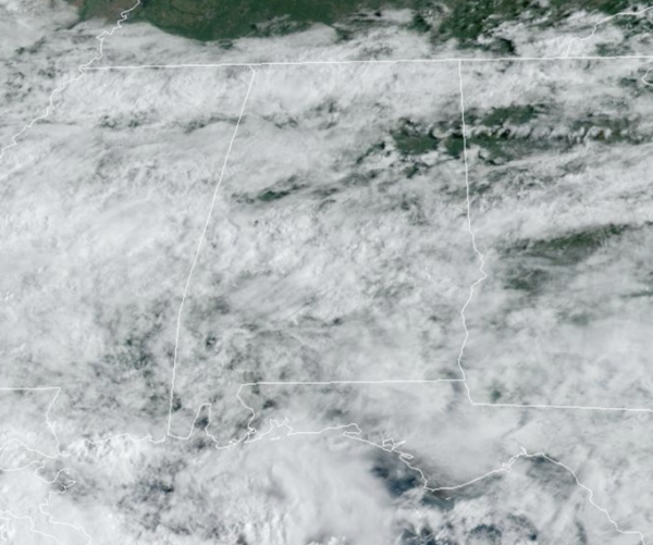
WET AT TIMES: Clouds and rain are increasing over the today and through the day tomorrow as a low pressure will track east along the Northern Gulf Coast.
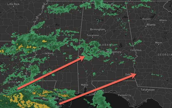
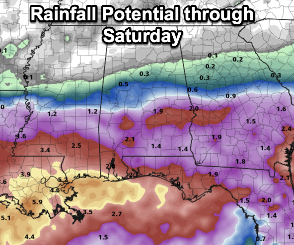
Periods of rain are likely both days for the southern 2/3 of the state with temperatures ranging from the mid 70s to low 80s. Rain amounts will range greatly across the state, little to nothing for the northern third of the state, less than an inch for the central third of the state, and 1-3 inches for the southern third of the state. There is no threat of severe weather with this system, and likely no thunder will occur.
BIRMINGHAM ALMANAC: For September 5th, the average high for Birmingham is 88° and the average low is 68°. The record high is 106° set in 1925, while the record low is 53° set in 1984. We average 0.14” of precipitation on this date, and the record value is 7.11” set in 2011.
ALL-TIME RECORD HIGH: On this date in 1925, the hottest temperatures ever recorded in the State of Alabama occurred at Centreville in Bibb County as the temperature soared to 112°. Every recording station in the state recorded a high of at least 100° that day. The summer of 1925 was blistering hot and the scorching temperatures were preceded by very dry conditions as much of Alabama was experiencing drought. That is how you get the hottest temperatures in the Deep South, heat waves are preceded by drought conditions, as dry air can get hotter than moist air. One last fact, Alabama is one of only two states to record its all-time record high in one of the non-traditional summer months of June, July, and August. The other state is Hawaii, which recorded its all-time record high of 100° in April.
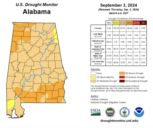
DROUGHT MONITOR: Speaking of drought, we are in one in Alabama. The latest drought monitor released this morning show over 97% of Alabama is in at least “moderate drought.” Over 25% of Alabama is in severe drought, including much of Northwest Alabama and much of South and Southeast Alabama, including all of the Wiregrass Region. The upcoming rains are certainly going to help parts of the state, by drought takes time to develop and takes time to dissipate.
FRIDAY NIGHT LIGHTS: For high school games across the state tomorrow night, some rain is likely over the southern 2/3 of the state. Not expecting much thunder, however, and temperatures will be in the 70s.
WEEKEND WEATHER: A much drier airmass will push into the state with a front on Saturday, setting the state for a very pleasant weekend across the Deep South. Mostly sunny, pleasant days and fair cool nights; highs will be in the 80s. Temperatures drop into the 50s over North Alabama early Sunday morning.
FOOTBALL WEATHER: Saturday Auburn will host California at Jordan-hare Stadium (2:30p CT kickoff)… the sky will be partly sunny, and a brief shower can’t be ruled out. Temperatures will hover in the low to mid 80s during the game.
Alabama will host South Florida Saturday evening in Tuscaloosa (6:00p CT kickoff)… the sky will be mostly clear with temperatures falling from the low 80s at kickoff, into the upper 60s by the final whistle.
UAB will be on the road; they take on Louisiana-Monroe Saturday evening (6:00p CT kickoff). The sky will be clear with about 83 degree at kickoff; temperatures drop to near 70 degrees by the fourth quarter.
INTO NEXT WEEK: For now most of the week looks rain-free with highs in the 80s and lows in the upper 50s and 60s. Very seasonal for early September, and overall a very nice week of weather across the state.
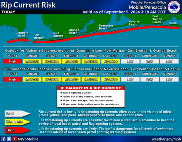
AT THE BEACH: It is going to be rather wet and unsettles in the coming days along the Gulf Coast. Clouds and rain will hold temperatures in the 70s and 80s, with little sunshine in the forecast. Rip current threats are moderate to high the rest of this week. Please pay attention to the Rip Current Flag Warning System at each beach as conditions can change through out the day.
IN THE TROPICS: We now have five areas the NHC is monitoring for potential development, but as of now, all five have a low chance of development.
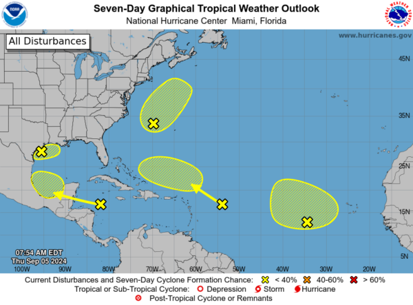
1. In the Northwest Gulf of Mexico, a trough of low pressure is producing widespread disorganized showers and thunderstorms across the northwestern Gulf of Mexico, including near the coasts of Louisiana and Texas. Upper-level winds are expected to become less conducive for development by Friday and Saturday as a frontal boundary approaches the system. Although development is unlikely, heavy rainfall is expected across portions of the northern Gulf Coast during the next day or so.
2. In the Northwestern Atlantic, a non-tropical area of low pressure located a few hundred miles east of North Carolina is producing disorganized showers and thunderstorms to the northeast and east of its center. This system could acquire some subtropical characteristics over the next couple of days while it moves generally north-northeastward, remaining offshore of the northeastern United States. Once the low moves over cooler waters by late Saturday, further subtropical development is not expected.
3. In the Eastern Tropical Atlantic, a broad area of low pressure over the eastern tropical Atlantic is producing disorganized showers and thunderstorms. Some slow development of this system is possible during the next several days while it drifts northwestward or northward.
4. In the Northwestern Caribbean Sea and Southwestern Gulf of Mexico, shower and thunderstorm activity has increased slightly in association with a westward-moving tropical wave located over the western Caribbean Sea. Significant development appears unlikely before the system reaches Belize and the Yucatan Peninsula by early Friday. Some development is possible late in the weekend into early next week after the system emerges over the southwestern Gulf of Mexico.
5. And in the Central Tropical Atlantic, another tropical wave located a few hundred miles east of the Leeward Islands is producing limited shower and thunderstorm activity. Strong upper-level winds are expected to limit development of this system during the next few days while it moves west-northwestward at 10 to 15 mph. By early next week, environmental conditions could become more conducive for some slow development while the system moves west-northwestward over the southwestern Atlantic Ocean.
Next names up are Francine, Gordon, Helen, Isaac, and Joyce.
WORLD TEMPERATURE EXTREMES: Over the last 24 hours, the highest observation outside the U.S. was 116.4F at Ejido Nuevo León, Mexico. The lowest observation was -91.1F at Vostok, Antarctica.
CONTIGUOUS TEMPERATURE EXTREMES: Over the last 24 hours, the highest observation was 117F at Death Valley, CA. The lowest observation was 25F at Peter Sinks, UT.
Category: Alabama's Weather, ALL POSTS
About the Author (Author Profile)
Macon, Georgia Television Chief Meteorologist, Birmingham native, and long time Contributor on AlabamaWX. Stormchaser. I did not choose Weather, it chose Me. College Football Fanatic. @Ryan_StinnetSubscribe
If you enjoyed this article, subscribe to receive more just like it.


