The 2024 Hurricane Season: Active….Then Very Quiet….What Is Happening? Breaking Down the Details and Showing the Latest from the NHC!
Been doing some reading this Wednesday afternoon on a great discussion from Colorado State University (CSU) on the 2024 Hurricane Season. It was predicted by many meteorological entities, that it was going to be a very active season and for good reason! Combination of a La Nina pattern with the abnormally warm ocean temperatures are just two reasons for an increase in confidence of a high number of storms. But, there are many factors that go into tropical system formation and there have been a few things that have happened to hinder that since the demise of Hurricane Ernesto on August 20.
The discussion from Colorado State looks at the record-setting start to the season, the current eerie quiet that has settled in, a look at the future and whether or not things may be changing and the season will play catch up. If you are a weather geek like me, then the entire article is worth the read. I will just be breaking down some of the bigger points in this article and giving a quick looks at what the NHC is monitoring currently in the tropics. Full Article.
How It All Started
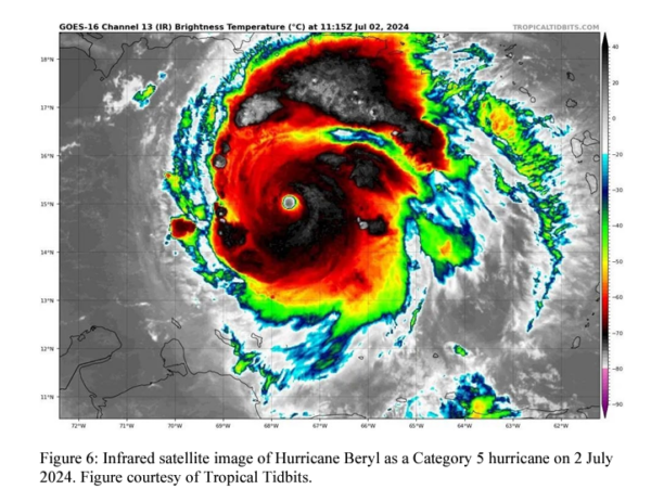
One signal that the hurricane season could be active was Hurricane Beryl, which became the earliest Category 5 hurricane in the Atlantic on record. Per the discussion, “Hurricane Beryl was an extremely impressive hurricane, generating the most ACE of any individual hurricane activity prior to 1 August on record.” ACE stands for Accumulated Cyclone Energy. The index from NOAA used to measure ACE is, “a wind energy index, defined as the sum of the squares of the maximum sustained surface wind speed (knots) measured every six hours for all named storms while they are at least tropical storm intensity.” Below is a satellite view of Beryl from the CSU article.
So, we started off the season with a bang! The CSU discussion states that since 1900, any season that has had an hurricane in the tropical Atlantic before August 1 were classified as above-average. Debby and Ernesto kept us on our toes throughout a good chunk of August. Then all of a sudden, the tropics went to sleep.
What On Earth Has Happened
If you don’t follow Mark Sudduth and his HurricaneTrack initiative, please consider doing so. I watched his video about the CSU report and got his take and I completely agree with his thoughts. Here is his latest video.
CSU has looked at the conditions over the past weeks that have hindered the hurricane season. These are the things we know and can show. Why are they happening? I like what Mark says, we don’t know why….yet. This will be something to be explored over the next few years. Predicting weather is hard. We are looking into the future based on what we have learned from the past and the current to try to give an analysis of the future. Sometimes the atmosphere throws in a monkey wrench (or 2) and it messes up the works. It is the job of the experts to analyze that to help with future forecasts. The goal for all of us in the weather enterprise is to take what we know and try to help people stay safe.
Reasons the tropics are struggling:
1) a northward-shifted monsoon trough resulting in African easterly waves emerging at too far north of a latitude
2) extremely warm upper level temperatures resulting in stabilization of the atmosphere
3) too much easterly shear in the eastern Atlantic
4) unfavorable subseasonal variability associated with the Madden-Julian oscillation (MJO). (Great explainer on MJO here)
What about the rest of the season?
Looking at the ensemble models, there are hints of a few disturbances trying to form (we will look at what is out there in just a moment)….but overall the projection from CSU is for below-normal activity over the next two weeks.
From late September, through October and November, due to more pronounced La Nina conditions and the extremely warm waters in place, there is a projected uptick in tropical activity projected. From CSU, “Typically, La Niña and a warm Caribbean enhance late season storm activity due to a strengthening of the Caribbean/Central American gyre. CSU issues an operational October-November Caribbean forecast, which will likely call for an active late season in the Caribbean given its two input parameters are ENSO and Caribbean sea surface temperatures.” So, there is a chance the season could change and become more active and the focused would the Caribbean which is where we typically watch late in the season. The season does not end until November 30.
What is all of this important?
Checks and balances. I like how CSU went through and showed, Hey, here is what we thought was going to happen and here is what has happened and why. And then go from there with what MAY happen moving forward. It is not to scare people or make something out of nothing. It is not that we are rooting for an active season. I actually prefer it to stay quiet so we don’t have major hurricanes heading toward any coastline! It is about trying to learn about our atmosphere and give people the tools they need to stay safe.
Current State of the Tropics
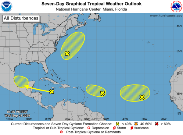
Here is the 2pm EDT outlook for the next 7 days from the NHC. Looks active doesn’t it? Well, all of these disturbances currently have a low end chance for development over the next 7 days.
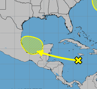
If there is one we are watching very closely, it would be this one:
The models are showing it crossing the Yucatan and then emerging into the Gulf of Mexico early next week. MAYBE some development at that time but there are a lot of uncertainties. It is a wait and see.


