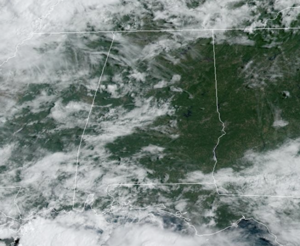
Midday Nowcast: Nice, Late Summer Day
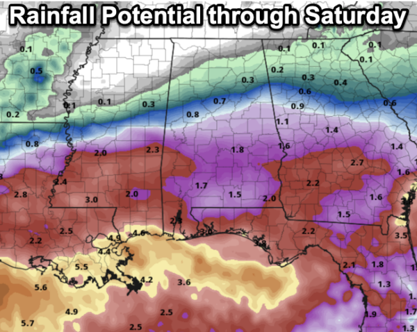
Mostly dry again today, and highs are in the mid 80s. Rain coverage will begin to increase over the southern counties of the state tomorrow and Friday as a low pressure will develop and track east across the Northern Gulf Coast. Periods of rain are likely both days for the southern 2/3 of the state with temperatures ranging from the mid 70s to low 80s. Rain amounts tomorrow through Saturday will range greatly across the state, little to nothing for the northern third of the state, close to one inch the central third of the state, and 1-3 inches for the southern third of the state. There is no threat of severe weather with this system, and likely no thunder will occur.
BIRMINGHAM ALMANAC: For September 4th, the average high for Birmingham is 89° and the average low is 69°. The record high is 105° set in 1925, while the record low is 50° set in 1952. We average 0.13” of precipitation on this date, and the record value is 1.95” set in 1939.
ACROSS THE USA: Excessive heat is forecast to impact the Southwest U.S. through much of California and into coastal Oregon and Washington today into this weekend. Excessive Heat Watches and Warnings, and Heat Advisories have been issued. The potential for heavy to excessive rainfall will shift across the Gulf Coast from west to east today through Friday.
FRIDAY NIGHT LIGHTS: For high school games across the state Friday night, some rain is likely over the southern 2/3 of the state. Not expecting much thunder, however, and temperatures will be in the 70s.
WEEKEND WEATHER: A much drier airmass will push into the state with a front on Saturday, setting the state for a very pleasant weekend across the Deep South. Mostly sunny, pleasant days and fair cool nights; highs will be in the 80s. Temperatures drop into the 50s over North Alabama early Sunday morning.
FOOTBALL WEATHER: Saturday Auburn will host California at Jordan-hare Stadium (2:30p CT kickoff)… the sky will be partly sunny, and a brief shower can’t be ruled out. Temperatures will hover in the low to mid 80s during the game.
Alabama will host South Florida Saturday evening in Tuscaloosa (6:00p CT kickoff)… the sky will be mostly clear with temperatures falling from the low 80s at kickoff, into the upper 60s by the final whistle.
UAB will be on the road; they take on Louisiana-Monroe Saturday evening (6:00p CT kickoff). The sky will be clear with about 83 degree at kickoff; temperatures drop to near 70 degrees by the fourth quarter.
INTO NEXT WEEK: For now most of the week looks rain-free with highs in the 80s and lows in the upper 50s and 60s. Very seasonal for early September, and overall a very nice week of weather across the state. We are heading into our driest and most pleasant months of the year, as humidity levels drop and comfortable temperatures become more common the rest of September and through October. Hopefully, we have no late season heat wave across the Deep South.
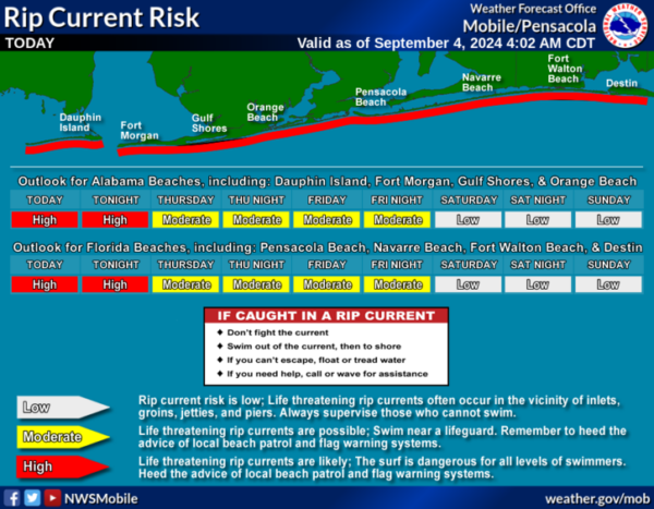
AT THE BEACH: Routine late summer weather for the Alabama and Northwest Florida Gulf Coast. Daily showers and storms and highs in the 90s today, falling into the 80s the rest of this week. Rip current threats are moderate to high the rest of this week. Please pay attention to the Rip Current Flag Warning System at each beach as conditions can change through out the day.
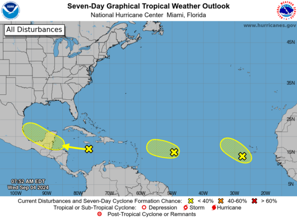
IN THE TROPICS: Three areas the NHC continues to monitor, but as of now, all three have a low chance of development.
1. Northwestern Caribbean Sea and Southwestern Gulf of Mexico, a tropical wave moving quickly westward at about 20 mph is producing a broad area of disorganized showers and thunderstorms near southeastern Cuba, Jamaica, and across portions of the central Caribbean Sea. Some development is possible late this week when the wave slows down over the northwestern Caribbean Sea or early next week over the southwestern Gulf of Mexico.
2. Central Tropical Atlantic Ocean, another tropical wave located about 800 miles east of the Lesser Antilles is producing limited shower and thunderstorm activity. Development of this system, if any, is expected to be slow to occur over the next couple of days while it moves west-northwestward at 10 to 15 mph. Environmental conditions are expected to become unfavorable for additional development by the end of the week.
3. Eastern Tropical Atlantic Ocean, a third tropical wave over the far eastern Atlantic is also producing disorganized shower activity. Some slow development of this system is possible during the next few days while it moves slowly northwestward at 5 to 10 mph over the eastern tropical Atlantic Ocean. This system could produce locally heavy rains across portions of the Cabo Verde Islands today.
Next names up are Francine, Gordon, and Helen.
WORLD TEMPERATURE EXTREMES: Over the last 24 hours, the highest observation outside the U.S. was 115.5F at Amarah, Iraq. The lowest observation was -86.8F at Vostok, Antarctica.
CONTIGUOUS TEMPERATURE EXTREMES: Over the last 24 hours, the highest observation was 116F at Death Valley, CA. The lowest observation was 27F at Stanley, ID.
Category: Alabama's Weather, ALL POSTS


