Midday Nowcast: Mostly Dry Labor Day
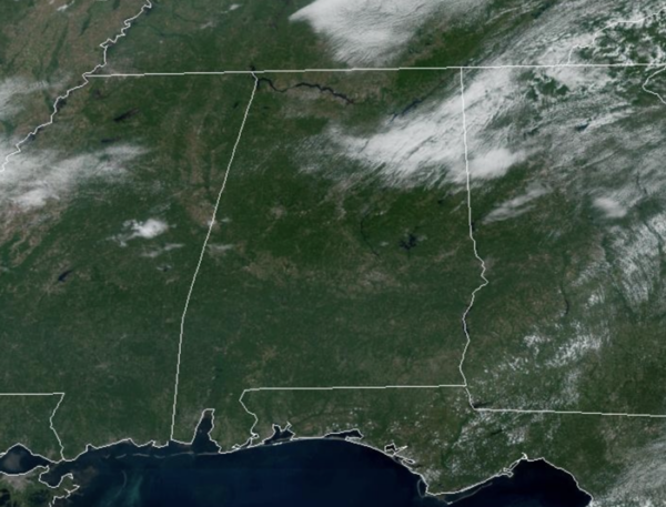
REST OF LABOR DAY: Plenty of sunshine across Alabama today is allowing temperatures to surge into the low 90s this afternoon. Most of Alabama will be dry today with only isolated showers or storms over the southern third of the state this afternoon.
BIRMINGHAM ALMANAC: For September 2nd, the average high for Birmingham is 89° and the average low is 69°. The record high is 98° set in 2011, while the record low is 55° set in 1987. We average 0.14” of precipitation on this date, and the record value is 2.73” set in 1920.
ACROSS THE USA: An active fire weather day is anticipated across the High Plains and Pacific Northwest/northern Great Basin due to dry and windy conditions. Locally heavy rainfall from showers and thunderstorms may lead to some scattered flash flooding over the Texas Hill country and along the central Texas Gulf Coast. Some thunderstorms are also expected along the coastal Carolinas into Georgia.
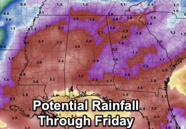
REST OF WEEK: Moisture levels rise tomorrow, and we will bring in the chance of scattered showers and thunderstorms, mostly during the afternoon and evening hours. A few showers or storms are possible on Wednesday, but rain coverage should be much higher Thursday and Friday. Periods of rain are likely on both days with temperatures only in the mid 70s over the northern half of the state. Rain amounts tomorrow through Friday will be in the two inch range for much of Alabama, with potential for 2-4 inches closer to the Gulf Coast, where a trough of low pressure will set up.
WEEKEND WEATHER: A much drier airmass will push into the state Friday night, setting the state for a very pleasant weekend across the Deep South. Mostly sunny warm days and fair cool nights; highs will be in the 80s. Temperatures drop into the 50s over North Alabama early Sunday morning.
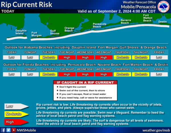
AT THE BEACH: Routine late summer weather for the Alabama and Northwest Florida Gulf Coast. Random, daily afternoon showers and storms and highs in the upper 80s and lower 90s. Rip current threats remain low for most locations this week, but of course pay attention to the Rip Current Flag Warning System at each beach as conditions can change through out the day.
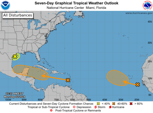
IN THE TROPICS: Three areas the NHC continues to monitor:
In the northwestern Gulf of Mexico, a broad and weak area of low pressure just offshore of the middle Texas coast continues to produce some disorganized shower activity along portions of the coast of Texas and over the adjacent waters of the northwestern Gulf of Mexico. This system is expected to meander for another day or so, and some slow development is possible if it remains offshore. On Tuesday, the low is forecast to move inland, and further development is not expected. Regardless, heavy rains could cause some flash flooding across portions of the Texas coast during the next couple of days. Formation chance through 7 days…low…10 percent.
Near the Lesser Antilles and Caribbean Sea, a tropical wave is producing disorganized thunderstorms and gusty winds across portions of the Lesser Antilles, Puerto Rico, and over the adjacent eastern Caribbean waters. Environmental conditions are forecast to become more conducive for development when the system reaches the western Caribbean Sea and southwestern Gulf of Mexico late this week and over the weekend, and a tropical depression could form during that time. Formation chance through 7 days…medium…40 percent.
In the eastern Tropical Atlantic, a tropical wave just offshore of the west coast of Africa is producing disorganized showers and thunderstorms. Environmental conditions are forecast to gradually become more conducive for development, and a tropical depression could form in a few days while the disturbance moves slowly west-northwestward or northwestward over the eastern tropical Atlantic Ocean. This system could produce areas of heavy rain and gusty winds across portions of the Cabo Verde Islands in a day or two. Formation chance through 7 days…medium…40 percent.
Next names up are Francine, Gordon, and Helen.
WORLD TEMPERATURE EXTREMES: Over the last 24 hours, the highest observation outside the U.S. was 117.0F at Omidieh, Iran. The lowest observation was -76.4F at Dome A, Antarctica.
CONTIGUOUS TEMPERATURE EXTREMES: Over the last 24 hours, the highest observation was 118F at Tecopa, CA. The lowest observation was 26F at Peter Sinks, UT.
Category: Alabama's Weather, ALL POSTS


