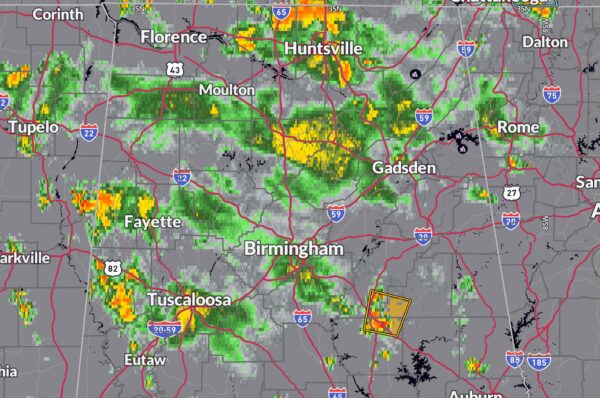
Alabama Update at 430pm
Convection has been doing its job all afternoon equalizing all the instability over Alabama by building strong pulse thunderstorms. A few of them produced wind damage, including isolated reports of trees down.
There was more significant concentrated damage in Cherokee county, especially around Cedar Bluff, where severe homes and vehicles suffered damage.
The strongest storms right now are in northern Coosa County along US-280. A severe thunderstorm warning has just been issued for parts of Talladega, Clay and Coosa counties. 60 mph winds are very possible with this storm.
The strongest storms have moved out of the Tuscaloosa area, where light rain continues. Good chance it will end before game time says James SPann at the Stadium, providing game day support. Those storms are now over Lamar, Fayette and Pickens Counties. Not severe at this time.
Strong storms are over northern Madison County in North Alabama.
Auburn is still clear from rain, just hot. There is a storm up for 431 south of Lafayette. It is not helping at Auburn though where it is 93F.
A storm weakened as it moved into Troy and reformed to the northwest of the city. No effect at the airport so far where it is a hot 93F.
Clear in Mobile for now for USA. Samford is looking good over in Carrolton GA.
Category: Alabama's Weather, ALL POSTS, Severe Weather


