Storms Popping Earlier than the Midday Hour on This Final Day of August
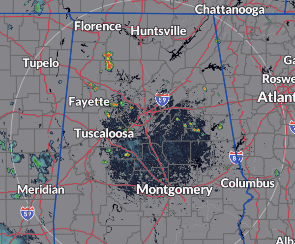
As we are nearing the noon hour in North and Central Alabama, we are already seeing scattered showers and storms popping up over the northern half of the area. Unfortunately, it will be very hard to tell who will get rain this afternoon and tonight as these are random, pop-up type storms. However, any storms that can stay together will have enough instability to become strong and even briefly severe. Current temperatures just before 12 pm were in the mid 80s to the lower 90s, and should top out in the lower to mid 90s. As mentioned earlier, scattered storms will be a possibility during tailgating and into the early parts of tonight’s football games in Tuscaloosa and Auburn. Chance will drop as the sun sets, but a shower or storm can’t be ruled out during the first quarter. Stay weather aware if outdoors.
The surface front is now trending slower, entering the northern parts of the state on Sunday, so I am reducing the chance of rain throughout the daylight hours. A few scattered showers and storms will be possible during the afternoon to early evening hours across the area, but rain chances will increase along and just ahead of the front as it moves across the AL/TN state line just before or around sunset. While a strong storm is possible early on, severe weather is not expected. Sunday’s highs will be in the upper 80s to the upper 90s.
Labor Day is also trending drier across the area as well, as only a limited number of isolated showers and storms will be possible along and ahead of the front that will have stalled out just south of the I-20 corridor. North of that, slightly drier air will move in, allowing for a dry day for those locations. Highs will top out in the upper 80s to the mid 90s. It will be a good day to get out there and enjoy whatever festivities you have. Just remember to take breaks and stay hydrated.
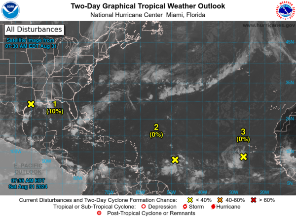
For the North Atlantic, Caribbean Sea, and Gulf of Mexico: In the Northwestern Gulf of Mexico, a broad area of low pressure near the upper Texas coast is generating some disorganized showers and thunderstorms along and just offshore the coasts of Texas and Louisiana. This system is expected to remain near the coast for much of next week, with slow development possible if it moves offshore. Regardless of development, heavy rains could lead to flash flooding across parts of coastal Louisiana and the upper Texas coast over the coming days. The formation chance through 48 hours is low at 10 percent, and through 7 days, it remains low at 20 percent.
Near the Lesser Antilles and Caribbean Sea, a tropical wave located several hundred miles east of the Lesser Antilles is producing some disorganized showers and thunderstorms. This disturbance is forecast to move westward and reach the Lesser Antilles by Monday. Environmental conditions are expected to be conducive for gradual development, with a tropical depression potentially forming as it continues westward across the Caribbean Sea through mid to late next week. The formation chance through 48 hours is low, near 0 percent, while the chance through 7 days is medium at 50 percent.
In the Eastern Tropical Atlantic, another tropical wave just west of the Cabo Verde Islands is generating disorganized shower and thunderstorm activity. Development, if any, should be slow as the system moves slowly westward to west-northwestward over the eastern and central tropical Atlantic through late next week. The formation chance through 48 hours is low, near 0 percent, and through 7 days, it remains low at 10 percent.
I want to send a big shoutout to Jen Narramore for stepping in and helping us out with severe and tropical weather coverage. You are greatly appreciated, and I just want to say thanks for all that you do!
Category: Alabama's Weather, ALL POSTS, Tropical


