Scattered Showers & Storms Possible Each Afternoon Through the Weekend
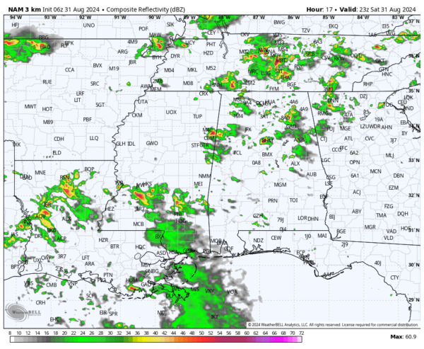
We’ll have a mainly dry morning to start with, but with the amount of humidity we have in Alabama, mixed with the heating of the day, scattered showers and storms will begin to fire up during the afternoon and look to linger into the evening to late night hours. While not everyone will see rain, some storms may become strong if they are able to stay together. For those heading to the football games in Tuscaloosa and Auburn, a scattered storm is not out of the question before and during the game, even though chances will drop as the sun sets. Highs across the area will be in the lower to mid 90s.
Sunday’s weather will feature scattered to numerous showers and storms along and north of 1-20, as a surface front moves into the area. Much of the activity will be along and just ahead of the front as it slowly dips southward. However, scattered afternoon showers and storms will be possible south of that. The front looks to stall out over the southern portions of the area by late tonight. Once again, some storms may become strong. Highs in the upper 80s to the mid 90s. By the way, Sunday is the first day of September, and is also the first day of meteorological fall.
As the front will be stalled out over the southern portions of the area on Labor Day, a few scattered showers and storms will be possible along and south of the front. North of the front, drier continental air will be moving in, allowing for a dry and slightly less humid day. Highs in the upper 80s to the mid 90s.
Unfortunately, the drier air only last for a day, as moisture returns from the east. Scattered to numerous showers and storms will be possible on Tuesday, mainly during the afternoon and evening. Highs in the mid 80s to the lower 90s.
A zonal flow returns on Wednesday, however, our rain chances will stay elevated. Scattered to numerous showers and storms will be possible during the afternoon and evening. Highs in the upper 70s to the mid 80s.
On Thursday, a trough looks to approach and move into the area, and potentially swinging another front through Central Alabama. For now, scattered showers and storms look to be likely at times, with some locations potentially getting a decent amount of rain. Highs in the lower to mid 80s.
And at the end of the forecast period on Friday, the front will continue to push through the area, keeping scattered showers and storms likely until the front passes your location. The front may exit the area by the late night hours. Highs in the lower to mid 80s.
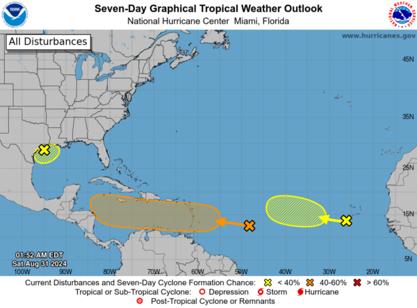
The National Hurricane Center is monitoring several areas in the Atlantic, Caribbean Sea, and Gulf of Mexico for potential tropical development.
In the Northwestern Gulf of Mexico, a surface trough of low pressure is causing disorganized showers and thunderstorms near the coasts of Texas and Louisiana. There’s currently no sign of a closed circulation, but some slow development is possible if the system remains offshore. Regardless of development, heavy rains could lead to flash flooding in parts of coastal Louisiana and the upper Texas coast over the next few days.
Meanwhile, a tropical wave several hundred miles east of the Lesser Antilles is showing some disorganized showers and thunderstorms. Gradual development is possible over the next few days, and a tropical depression could form next week as it moves westward, potentially reaching the Lesser Antilles by Monday and continuing across the Caribbean Sea through mid to late week.
Lastly, another tropical wave near the Cabo Verde Islands is producing disorganized activity. There’s a low chance for development through late next week as it moves slowly west-northwest across the eastern and central tropical Atlantic.
Category: Alabama's Weather, ALL POSTS, Tropical, Weather Xtreme Videos


