Scattered Afternoon/Evening Storms Over The Weekend
RADAR CHECK: Again this afternoon we have random, scattered showers and thunderstorms across Alabama. Some are producing heavy rain and strong winds along with lots of lightning. They will fade after sunset, and most will be gone by 10:00 p.m. Away from the storms the sky is partly sunny with temperatures mostly in the 90s.
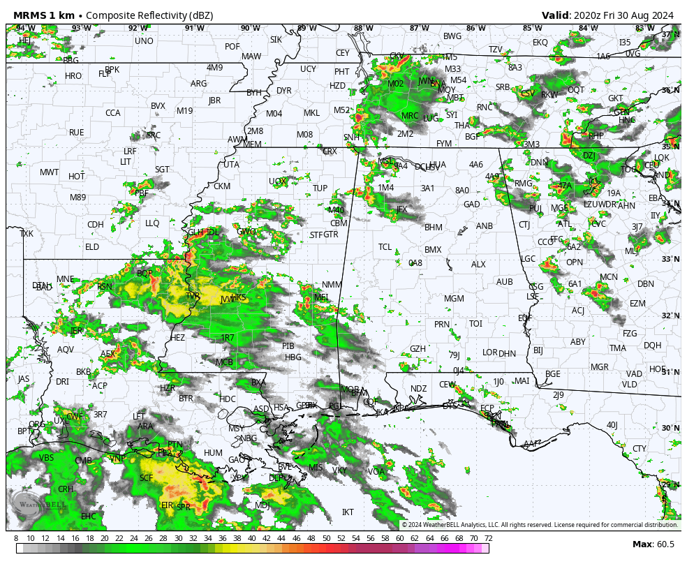
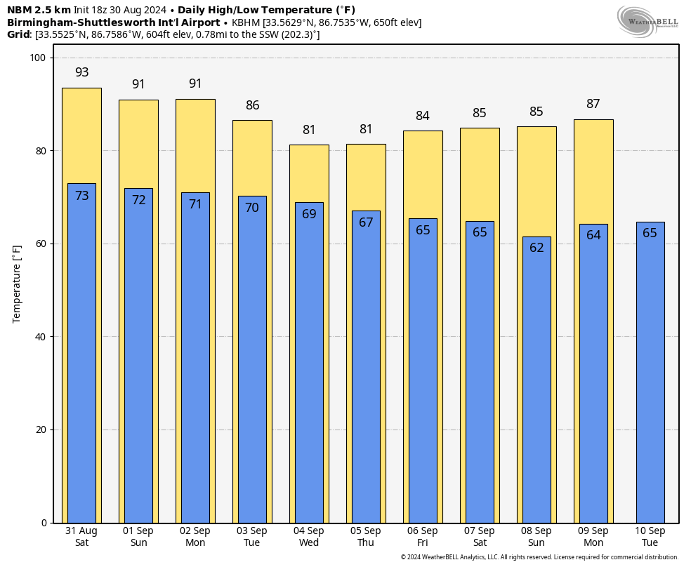
Routine late summer weather for Alabama will continue through the holiday weekend. Partly sunny days with random, scattered, mostly afternoon and evening showers and thunderstorms. Most of the storms will come from about 1:00 until 10:00 p.m…. the chance of any spot seeing rain is 40-50 percent tomorrow through Monday. Highs will be mostly in the low 90s.
REST OF NEXT WEEK: Heat levels drop considerably; highs will be close to 80 over the northern half of the state by mid-week, with lows in the 60s. And, we will maintain some risk of scattered showers and storms on a daily basis. Global models suggest rain coverage could be highest toward the end of the week with the approach of a surface front; See the video briefing for maps, graphics, and more details.
FOOTBALL WEATHER: Alabama hosts Western Kentucky tomorrow evening at Bryant-Denny Stadium (6:00p CT kickoff)… a brief shower or storm can’t be ruled out during the first half, otherwise mostly fair with temperatures falling from near 88 degrees at kickoff to near 80 by the final whistle. Auburn will host Alabama A&M at Jordan-Hare Stadium (6:30p CT kickoff)… again a shower or storm is possible during the first half, otherwise mostly fair with temperatures falling through the 80s.
Troy will host Nevada tomorrow evening (6:00p CT kickoff)… some risk of a shower or storm during the first half, otherwise fair with temperatures falling from around 87 degrees at kickoff, to near 80 by the final whistle.
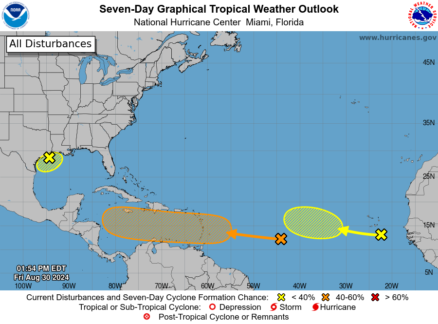
TROPICS: NHC is monitoring three areas of interest this afternoon; one just coming off the coast of Africa, another one in the middle of the Atlantic between the Lesser Antilles and the coast of Africa, and a third one over the northwest Gulf of Mexico.
The surface trough of low pressure over the northwestern Gulf is producing a large area of disorganized showers and thunderstorms along and just offshore the coasts of Texas and Louisiana. This system is expected to meander near the coast through much of next week, and some slow development is possible if it remains offshore. Regardless of development, heavy rains could cause some flash flooding across portions of coastal Louisiana and the upper Texas coast during the next few days. NHC gives it a 20 percent chance of development.
The wave just off the African coast has only a 20 percent chance of development over the next seven days. The focus remains on the lead wave over the central Tropical Atlantic; showers and thunderstorms associated with the wave remain disorganized. Gradual development of this system is possible during the next few days, and a tropical depression could form some time next week while it moves westward, reaching the Lesser Antilles on Monday and continuing across the Caribbean Sea through the middle to latter part of the week. NHC gives it a 40 percent chance of development over the next seven days. It is simply too early to know if this develops into a tropical storm or hurricane, or if it enters the Gulf of Mexico. We will keep a close eye on it.
ON THIS DATE IN 2023: Idalia made landfall in the Big Bend region of Florida as a low-end Category 3 hurricane.
Idalia’s primary impact was devastating storm surge across the coastal Big Bend in Levy, Dixie, and Taylor counties. Storm surge inundations of 7 to 12 feet along the coast were some of the highest values recorded since the 1993 Storm of the Century. In some locations, according to local residents, values exceeded those observed in the 1993 Storm of Century. Idalia moved ashore during low tide, and if not for that storm surge values could have easily been 3 to 4 feet higher had Idalia moved onshore only 4 to 6 hours later at high tide. In addition to surge, wind and flooding damage was recorded well inland into Georgia.
Look for my next video briefing here by 6:00 a.m. Monday… enjoy the weekend!
Category: Alabama's Weather, ALL POSTS, Weather Xtreme Videos
About the Author (Author Profile)
James Spann is one of the most recognized and trusted television meteorologists in the industry. He holds the AMS CCM designation and television seals from the AMS and NWA. He is a past winner of the Broadcast Meteorologist of the Year from both professional organizations.Subscribe
If you enjoyed this article, subscribe to receive more just like it.


