Midday Nowcast: Hot with Scattered Storms through Labor Day
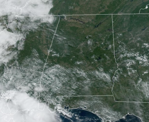
Afternoon temperatures are in the 90s today, and we will again mention scattered afternoon showers and storms, but most locations will remain dry. Rain chances are in the 25-45% range. Like the past few days, afternoon storms will be strong, and could reach severe limits, producing hail and damaging wind gusts. Also, all summer storms produce tremendous amounts of lightning and tropical downpours.
FRIDAY NIGHT LIGHTS: For those high school games tonight, it will be hot and humid and most stadium will be dry, but we note, there will be a few storms across the Alabama landscape this evening. These could impact some stadiums.
BIRMINGHAM ALMANAC: For August 30th, the average high for Birmingham is 89° and the average low is 70°. The record high is 100° set in 1995, while the record low is 54° set in 1992. We average 0.13” of precipitation on this date, and the record value is 1.40” set in 1956.
ACROSS THE USA: High heat and humidity continue across portions of the Mid-Mississippi, Ohio and Tennessee Valleys today. A break in the heat and humidity to more typical late August temperatures is expected going into the Labor Day weekend. Scattered strong to severe storms are possible across eastern lower Michigan today.
LABOR DAY WEEKEND: Expect highs in the mid 90s tomorrow, and low 90s Sunday and Monday as heat levels slowly begin to come down as the upper ridge weakens. Random, scattered showers and thunderstorms are expect all three days. Most of the showers and storms will come during the afternoon and evening hours, generally between 2PM-10PM. Odds of any one spot seeing rain each day is in the 30-40% range tomorrow and Sunday, increasing to around 50% on Labor Day Monday.
FOOTBALL WEATHER: Alabama hosts Western Kentucky tomorrow evening at Bryant-Denny Stadium (6:00p CT kickoff)… a brief shower or storm can’t be ruled out during the first half, otherwise mostly fair with temperatures falling from near 89 degrees at kickoff to the upper 70s by the final whistle.
Auburn will host Alabama A&M at Jordan-Hare Stadium (6:30p CT kickoff)… again a shower or storm is possible (but not likely) during the first half, otherwise mostly fair with upper 80s at kickoff, and upper 70s by the fourth quarter.
Troy will host Nevada tomorrow evening (6:00p CT kickoff)… an outside risk of a shower or storm during the first half, otherwise fair with temperatures falling from around 90 degrees at kickoff, to near 80 by the final whistle.
NEXT WEEK: The heat ridge will continue to shift to the west and we are forecasting highs in the 80s next week, much cooler than this week. Showers and storms will be a bit more numerous next week, and is part of the reason why temperatures will be cooler. Rain chance will be in the 50-60% range most days next week.
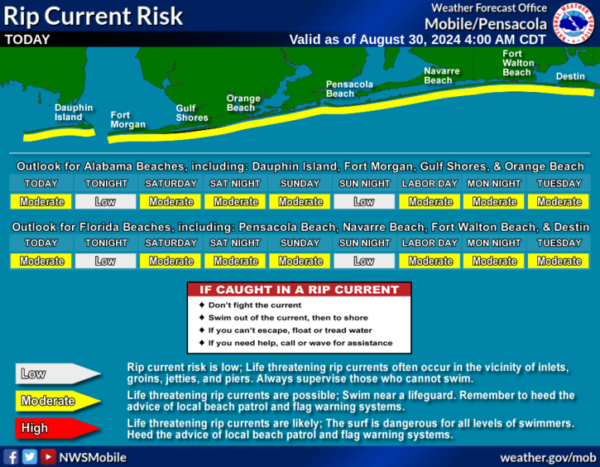
AT THE BEACH: Routine late summer weather for the Alabama and Northwest Florida Gulf Coast. Random, daily afternoon showers and storms and highs in the upper 80s and lower 90s. Rip current threats remain low for most locations this week, but of course pay attention to the Rip Current Flag Warning System at each beach as conditions can change through out the day.
IN THE TROPICS: Showers and thunderstorms associated with a tropical wave over the central tropical Atlantic remain disorganized. Gradual development of this system is possible during the next few days, and a tropical depression could form some time next week while it moves westward, reaching the Lesser Antilles on Monday and continuing across the Caribbean Sea through the middle to latter part of the week.Formation chance through 7 days…medium…40 percent.

Also in the Eastern Tropical Atlantic, another tropical wave between the west coast of Africa and the Cabo Verde Islands is producing minimal shower and thunderstorm activity. Some slow development of this system is possible through late next week while it moves slowly to the west-northwest over the eastern and central tropical Atlantic. Formation chance through 7 days…low…20 percent.
Next names up are Francine and Gordon.
WORLD TEMPERATURE EXTREMES: Over the last 24 hours, the highest observation outside the U.S. was 119.8F at Sunaynah, Oman. The lowest observation was -84.1F at Concordia, Antarctica.
CONTIGUOUS TEMPERATURE EXTREMES: Over the last 24 hours, the highest observation was 114F at Death Valley, CA. The lowest observation was 18F at Peter Sinks, UT.
Category: Alabama's Weather, ALL POSTS
About the Author (Author Profile)
Macon, Georgia Television Chief Meteorologist, Birmingham native, and long time Contributor on AlabamaWX. Stormchaser. I did not choose Weather, it chose Me. College Football Fanatic. @Ryan_StinnetSubscribe
If you enjoyed this article, subscribe to receive more just like it.


