Midday Nowcast: Mainly Sunny with Seasonal Temperatures
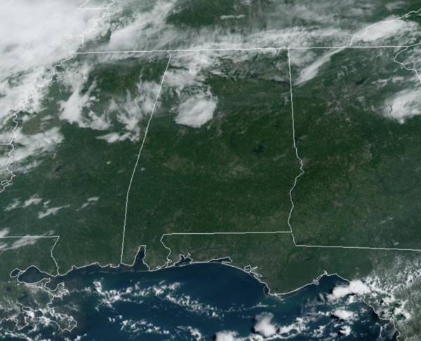
A mainly sunny sky across Alabama today, and after another refreshing morning, we are seeing temperatures in the low 90s this afternoon, which are right where they should be this time of year.
BIRMINGHAM ALMANAC: For August 12th, the average high for Birmingham is 91° and the average low is 72°. The record high is 102° set in 2010, while the record low is 58° set in 1969. We average 0.14” of precipitation on this date, and the record value is 2.52” set in 1998.
ACROSS THE USA: Heavy rainfall from scattered thunderstorms is expected across the Southwest, Intermountain West, and Plains. Isolated dry thunderstorms may initiate additional fires across the west. The coastal Carolinas may experience flash floods in the coming days due to repeated thunderstorms. Dangerous heat builds for the South. A potential tropical storm is approaching the USVI and Puerto Rico by mid-week.
REST OF WEEK: Dry weather continues tomorrow, but moisture levels begin to rise on Wednesday, we will bring the risk of a few isolated showers or storms for the second half of the week, mainly during the afternoon and evening hours. Highest coverage of showers will likely come on Friday with the approach of a front, but even then it certainly won’t rain everywhere. Highs will remain in the low 90s, which are right a seasonal averages for mid-August.
THE ALABAMA WEEKEND: Global models suggest another surge of dry air will slowly move into the Deep South Saturday; we will hang on to some risk of scattered showers, mainly over the southern half of the state, as the front drifts southward. And, for now, Sunday looks rain-free statewide. Highs will hold mostly in the low 90s; humidity levels will drop again over the northern half of the state.
NEXT WEEK: Overall, the quiet weather pattern will continue across Alabama, and next week, looks very similar to this week. Dry weather will likely continue Monday and Tuesday; a few showers or storms are possible over the latter half of the week. Temperatures remain near average levels with highs in the low 90s.
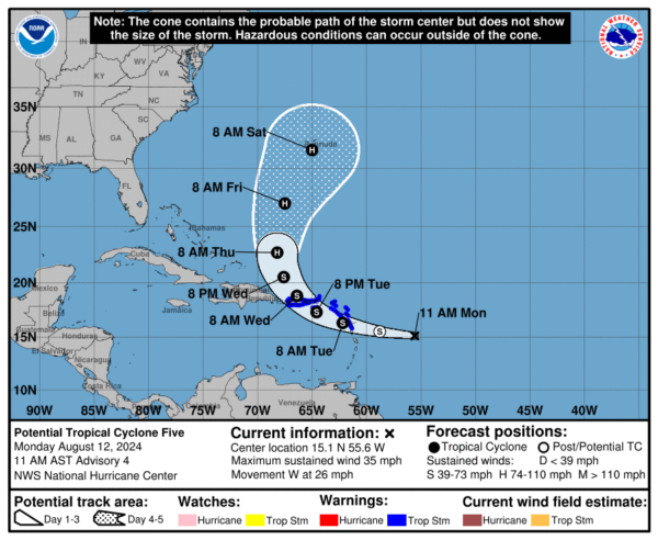
SOON TO BE ERNESTO: At 1100 AM AST, potential tropical cyclone five was centered near latitude 15.1 North, longitude 55.6 West. The system is moving toward the west near 26 mph. A westward to west-northwestward motion with some decrease in forward speed is expected during the next couple of days. On the forecast track, the disturbance is expected to move across portions of the Leeward Islands late tonight or Tuesday and approach the U.S. and British Virgin Islands and Puerto Rico Tuesday evening. Then, the disturbance is forecast to move away from Puerto Rico over the western Atlantic through midweek.
Maximum sustained winds have increased to near 35 mph with higher gusts. Some strengthening is forecast during the next couple of days, and the disturbance is expected to become a tropical depression later today or tonight and become a tropical storm as it nears the Leeward Islands. Formation chance high: 90 percent. The estimated minimum central pressure is 1010 mb (29.83 inches).
WORLD TEMPERATURE EXTREMES: Over the last 24 hours, the highest observation outside the U.S. was 119.7F at Omidieh, Iran. The lowest observation was -94.2F at Vostok, Antarctica.
CONTIGUOUS TEMPERATURE EXTREMES: Over the last 24 hours, the highest observation was 119F at Stovepipe Wells, CA. The lowest observation was 33F at Davis, WV.
Category: Alabama's Weather, ALL POSTS, Tropical


