
Tropical Storm Debby Forms…Will Become Hurricane Before Landfall Monday in Florida Big Bend…Threat to Georgia/Carolina Coasts
Here is the 4 pm CDT update on now Tropical Storm Debby….
QUICK FACTS AT 4 PM CDT
———————————————–
LOCATION…21.4N 79.7W
ABOUT 75 MI…125 KM S OF CAIBARIEN CUBA
ABOUT 260 MI…415 KM SSE OF KEY WEST FLORIDA
MAXIMUM SUSTAINED WINDS…30 MPH…45 KM/H
PRESENT MOVEMENT…WNW OR 285 DEGREES AT 17 MPH…28 KM/H
MINIMUM CENTRAL PRESSURE…1010 MB…29.83 INCHES
Debby is officially forecast to become a hurricane before landfall early Monday:
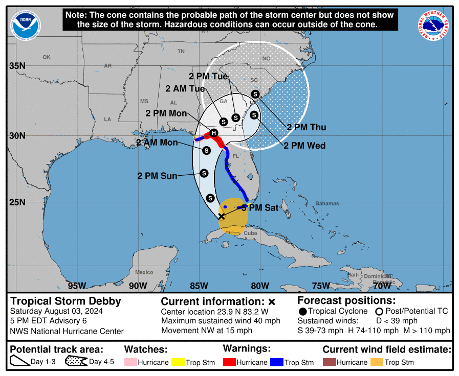
The storm’s projected path shows a northwestward and then northward movement, with a potential turn to the northeast occurring Sunday night. The hurricane will make landfall in Taylor County, Florida, on Monday morning.This trajectory positions Debby to pose a significant threat along Florida’s Big Bend and later along the Southeast coast of the United States, from Savannah, Georgia, to Wilmington, North Carolina.
The system will re-emerge into the Atlantic late Monday or Monday night as a tropical storm. Most models indicate a potential stall in the southeastern Atlantic region, with varying scenarios for Debby’s progression. The TVCN and GFS models suggest that the storm may linger near Savannah and Hilton Head, affecting these areas through at least Thursday. Meanwhile, the Canadian model proposes that Debby could stall over southern Georgia, while the European model forecasts the system to remain over the warm waters of the Atlantic, potentially making a secondary landfall near Charleston. Notably, the ICON model predicts a stronger system, potentially reaching Wilmington, NC, as a powerful 960 MB hurricane. We will be watching the modeling unfold in the next couple of days.
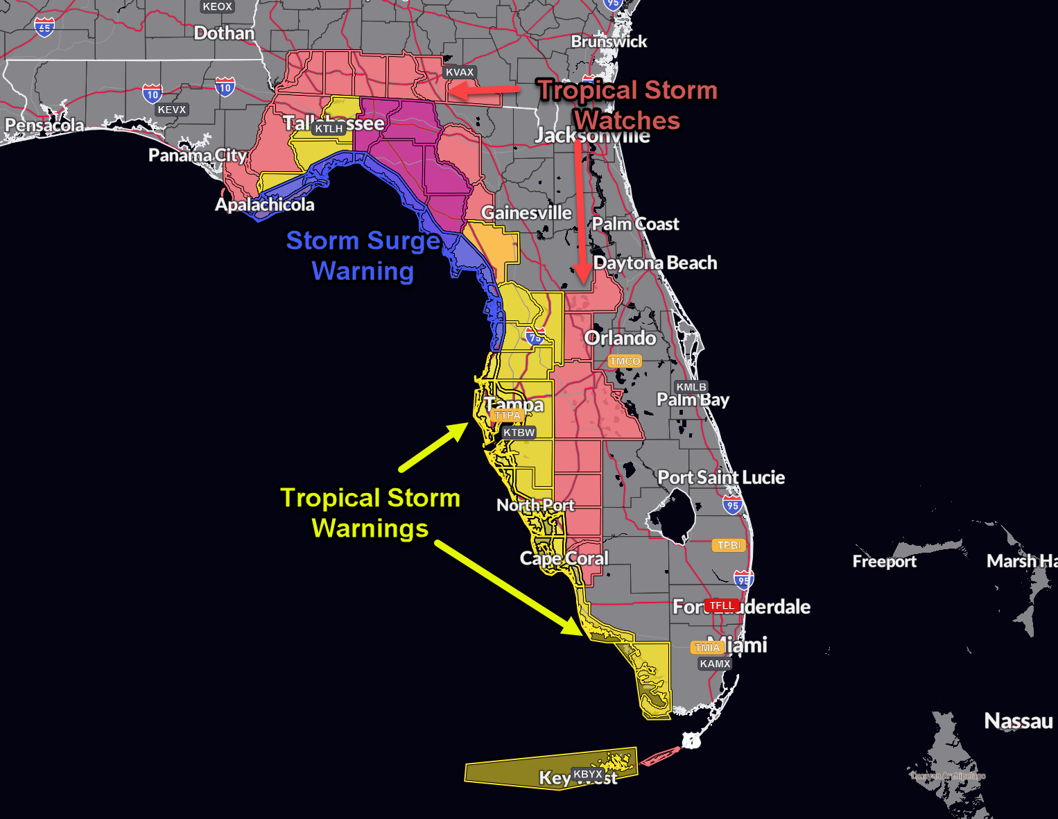
Here are current watches and warnings:
The convection associated with Debby) is increasing slowly this afternoon. The inner core has not cormed yet, but structure is beginning to improve. The system is very large. Upper divergence is evident and wind shear is light. The center appears to be consolidating just off the northern coast of Cuba.
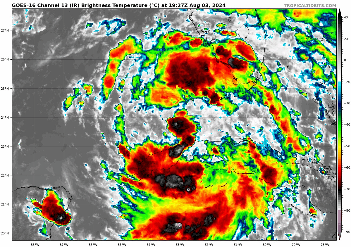
Outer rainbands are affecting Florida already. Winds recently gusted to 48 mph in Punta Gorda, Florida. So far, low level shear is weak, so we haven’t see tornadoes in Florida yet. Tornadoes will begin to affect the Florida Keys and the Peninsula of Florida tonight into Sunday.
Very warm sea surface temperatures of 31C (88F) are over the Gulf of Mexico.
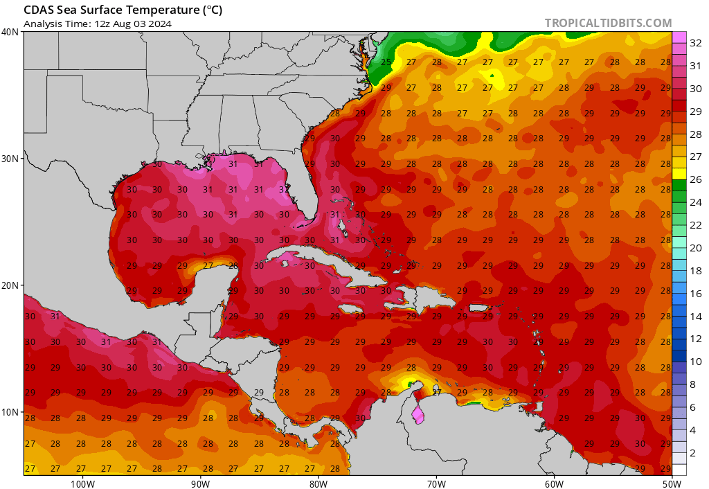
Oceanic heat content values are extreme along the north coast of Cuba, but lessen a bit as you move northward into the Gulf.
Wind shear will be light along the track. Upper divergence will be favorable. All of this combined with some of the hottest water temperatures we have seen in the Gulf, especially so early, will set the stage for strengthening. The only thing that might hold it back might be the lack of an inner core. The bottom line is that Debby will likely become a hurricane and will be strengthening up to landfall.
Storm surge will be a problem along the west coast of Florida. Here are values from the NHC forecast:
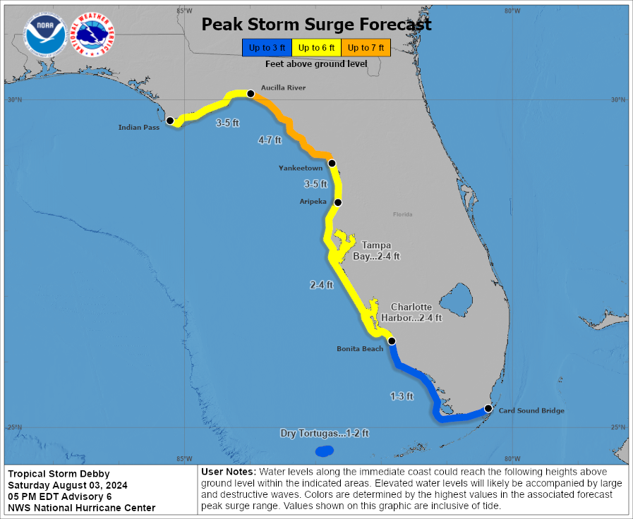
Peak surge could reach 4-7 feet between the Aucilla River and Yankeetown, Florida, a place steeped in Sunshine State hurricane lore. This peak surge area of course includes Keaton Beach, Steinhatchee, devastated by Hurricane Idalia last year, Horseshoe Beach, and Cedar Key, Florida.
Storm surge will become a problem next week along the Georgia and Carolina coasts late Monday through Thursday of next week.
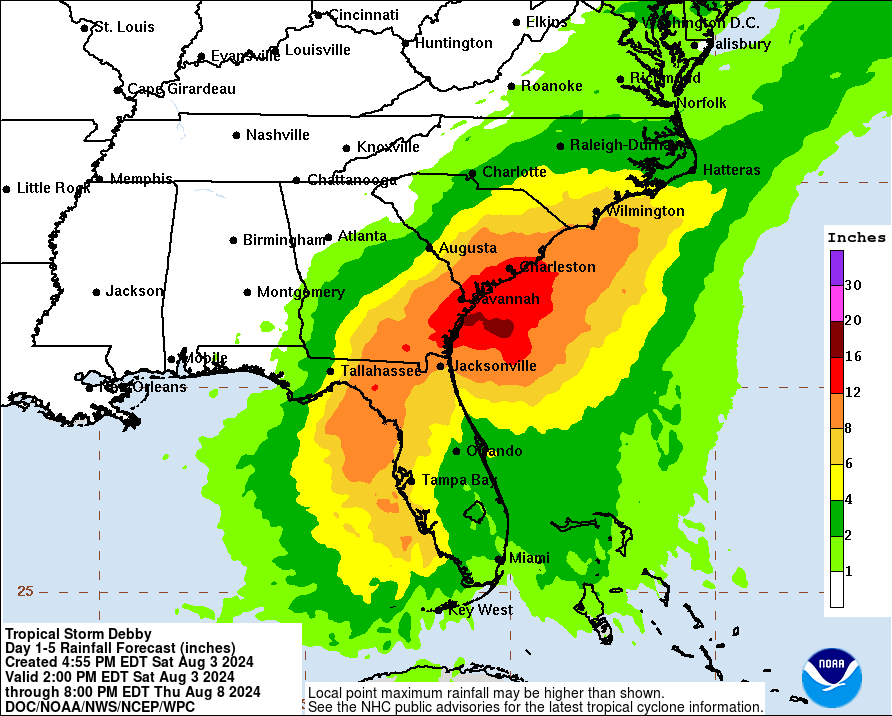
Rainfall will be heavy with 8-12 inches possible next week along the coasts of Georgia and the Carolinas, with a chance for upwards of 16 inches. This could cause devastating flooding in places like Savannah and Charleston as well as Myrtle Beach.
About the Author (Author Profile)
Bill Murray is the President of The Weather Factory. He is the site's official weather historian and a weekend forecaster. He also anchors the site's severe weather coverage. Bill Murray is the proud holder of National Weather Association Digital Seal #0001 @wxhistorianSubscribe
If you enjoyed this article, subscribe to receive more just like it.


