
Tropical Depression Four Advisory 5: New Watches and Warnings Issued For Portions of Florida.
The National Hurricane Center has issued their latest advisory as of 10am CDT. This is a larger overview of this system and the forecast. It contains updates to watches and warnings issued and a fuller discussion.
Public Advisory Information:
SUMMARY OF 1100 AM EDT…1500 UTC…INFORMATION
LOCATION…22.8N 82.0W
ABOUT 40 MI…60 KM SE OF HAVANA CUBA
ABOUT 125 MI…200 KM S OF KEY WEST FLORIDA
MAXIMUM SUSTAINED WINDS…35 MPH…55 KM/H
PRESENT MOVEMENT…WNW OR 300 DEGREES AT 15 MPH…24 KM/H
MINIMUM CENTRAL PRESSURE…1009 MB…29.80 INCHES
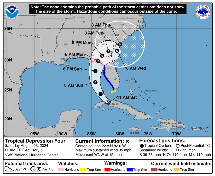
Summary of Watches and Warnings in Effect:
A Hurricane Watch is in effect for…
* Indian Pass to Yankeetown
A Tropical Storm Warning is in effect for…
* The Dry Tortugas
* West coast of the Florida peninsula from south of Yankeetown
to East Cape Sable
A Tropical Storm Watch is in effect for…
* The Florida Keys south of the Channel 5 Bridge
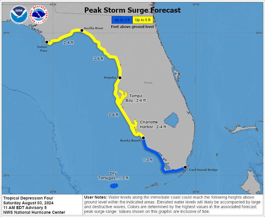
A Storm Surge Warning is in effect for…
* Aripeka northward to the Aucilla River
A Storm Surge Watch is in effect for…
* Bonita Beach northward to Aripeka, including Tampa Bay
and Charlotte Harbor
* West of the Aucilla River to Indian Pass
Discussion and Outlook:
- The tropical depression is still moving to the west-northwest around 15 mph but does appear to be jogging a but more northwesterly. A more pronounced turn to the northwest is anticipated today and then more of a northerly track will commence Sunday. After that a northeasterly path (and a slower one) will occur Sunday Night and Monday. At this point we could have a strong tropical storm/minimal hurricane crossing into the Florida Big Bend region.
- After landfall, things get sticky with the forecast. Weakening steering currents will allow soon to be Debby to slow down as it moves across north Florida and into Georgia. Here is an excerpt from the NHC discussion:
The uncertainty in the forecast increases significantly after 72 h as the cyclone interacts with a portion of the U.S. trough. The current GFS and ECMWF forecast the system to move into the Atlantic, and then turn back toward the southeastern U.S. coast by 120 h. On the other hand, the Canadian model moves the cyclone slowly northeastward across the southeastern states and does not bring it over the Atlantic. This portion of the new forecast track shows a slower forward motion than the previous track due to changes in the GFS forecast since the previous advisory.
- Maximum sustained winds are now coming in at 35 mph. This increase in intensity is based on surface observations in the Florida Keys and a satellite intensity estimate. Strengthening is forecast and we could have Tropical storm Debby by tonight. Conditions in the Gulf are conducive to rapid strengthening Sunday and this system could near hurricane strength has it approaches the Florida Gulf Coast.
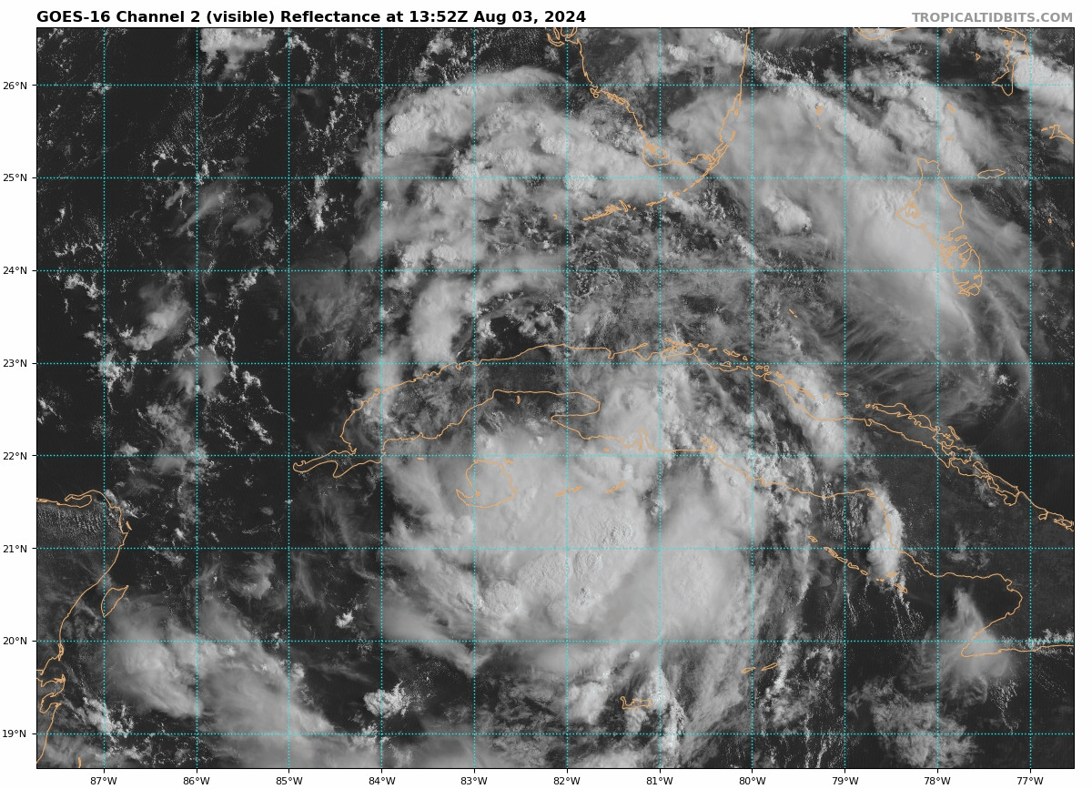
Latest loop of the Visible Hi-Res (0.5 km) Satellite via Tropical Tidbits.
Key Messages from the National Hurricane Center:
1. Heavy rainfall will likely result in locally considerable flash and urban flooding across portions of Florida and the coastal areas of the Southeast this weekend through Thursday morning. River flooding is also expected.
2. Hurricane conditions are possible late Sunday in portions of the Florida Gulf Coast and Big Bend region where a Hurricane Watch is in effect. Tropical storm conditions are expected farther south along Florida’s west coast, including the Tampa Bay area, and in the Dry Tortugas where Tropical Storm Warnings are in effect.
3. There is a danger of life-threatening storm surge inundation along portions of the west coast of Florida from Aripeka to the Aucilla River. Life-threatening storm surge is possible west of Aucilla River to Indian Pass and south of Aripeka to Bonita Beach, including Tampa Bay and Charlotte Harbor.
4. Impacts from storm surge, strong winds, and heavy rains are possible elsewhere in Florida and along the southeast coast of the United States from Georgia to North Carolina through the middle of next week, and interests in those areas should continue to monitor the progress of this system. Additional watches and warnings will likely be required later today.
Alabama Impacts:
The state of Alabama will be on the drier side of the circulation around this tropical system. No major impacts expected at this time. Increased swells will increase the rip current threat especially east for the Florida Panhandle beaches.
Category: Alabama's Weather, ALL POSTS, Tropical
About the Author (Author Profile)
Subscribe
If you enjoyed this article, subscribe to receive more just like it.


