Potential Tropical Cyclone Four Advisory 2: New advisories for Florida
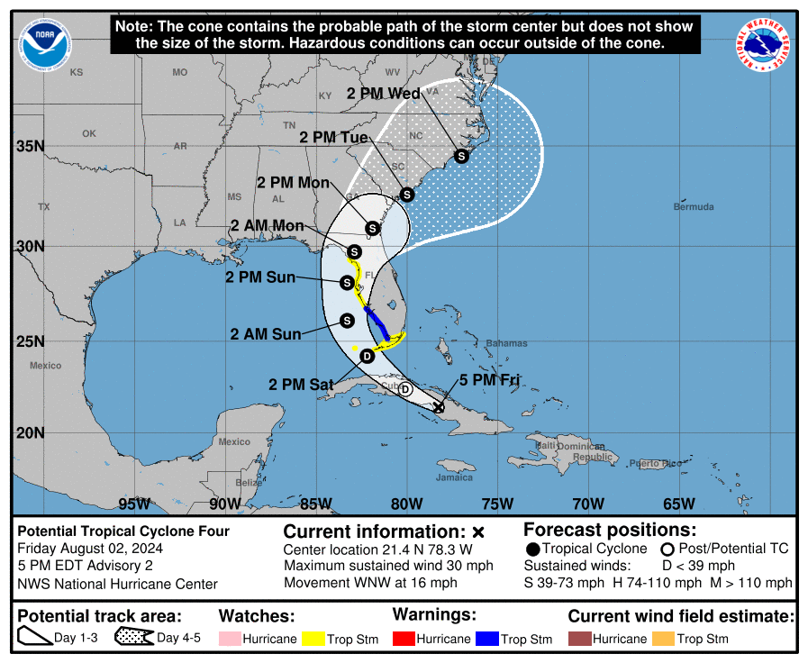
Here is the latest update from the National Hurricane Center about the disturbance moving over Cuba. Convection has flared over the past few hours, but still not seeing a well-define circulation, so no tropical depression designation given yet. A NOAA Hurricane Hunter is currently investigating the northern side of the wave, and a combination of
its dropsondes and earlier scatterometer data suggest that the maximum winds remain near 25 kt.
The disturbance has been generally moving in a westerly direction. A turn toward the northwest and north is expected during the next couple of days as the system moves into a break in the subtropical ridge caused by a mid-latitude trough over the Ohio Valley.
As is the case with forecasting the tropics, there are some things being monitored that is putting a fly in the ointment of confidence on the future track. From the NHC discussion:
First, the GFS moves the system much faster northeastward, and by 72 h it is forecasting the center to be off of the South Carolina coast. Meanwhile, the ECMWF and UKMET still have the center over the Gulf of Mexico. Second, due to the track being almost parallel to both the west coast of the Florida peninsula and the southeastern U. S. coast, small changes in the track could cause large differences in potential landfalls and which land areas receive the strongest impacts.
Once this system moves away from Cuba, it should intensify and we may have a depression by Saturday afternoon. Light shear exists over the Gulf of Mexico and very warm water temperatures so there is high confidence the storm will strengthen. But how strong will it get? From the discussion:
The two biggest uncertainties in the intensity forecast are how long the system will remain offshore of Florida and how long it will take to consolidate. The system is likely to weaken as it crosses Florida, with re-intensification likely over the Atlantic after 72 h.
Heavy rain across the Florida peninsula is one of the main hazards expected with this system. 4-8″ of rain, locally up to a foot a possibility.

With the track remaining east, no major impacts expected to Alabama. There will be an increasing swell as the storm moves north and that will yield a higher rip current risk for the Alabama beaches and for those along the Florida Panhandle.
Category: Alabama's Weather, ALL POSTS, Tropical
About the Author (Author Profile)
Owner of Tornado Talk. Radio broadcast meteorologist with The Storm Report. WeatherBrains Panelist. B.S. Meteorology from Penn State University.Subscribe
If you enjoyed this article, subscribe to receive more just like it.


