Tuesday Morning Weather Briefing Video: Heating Up
Yesterday, upper 80s and low 90s were recorded across Alabama, with showers and storms developing in the afternoon. The radar was active, with storms producing significant lightning and tropical downpours, leading to localized flash flooding. This pattern had persisted over the past few days, causing frequent rainfall across the state. Some strong storms moved down into Northeast Alabama after mid-afternoon, triggering several severe thunderstorm warnings. With high dewpoints in the middle and upper 70s, heat index values flirted with dangerous levels and heat advisories were posted for part of the area.
YOUR TUESDAY FORECAST: HEAT AND SCATTERED STORMS
Expect temperatures to climb into the mid-90s in most areas today. The day will start with partly cloudy skies, but by late morning, diurnal convective activity will increase. Scattered showers and thunderstorms are likely, especially in the southeastern and southern parts of the state, where instability and high shear could lead to stronger storms.
HEAT ADVISORIES FOR TODAY
Heat advisories are in effect for the Tennessee Valley of North Alabama, much of West Central and South Central Alabama, and Southwest Alabama through Tuesday evening. Heat index values are expected to reach 105-110F in the heat advisory areas. This can cause heat related illness in individuals exposed to the heat for any extended period. Take frequent breaks in air conditioning if you ar working, playing, or just hanging out outdoors. Drink plenty of liquids, but avoid alcohol. Wear appropriate clothing. Make sure vulnerable people and pets near you are ok.
HOTTER THROUGH THE WEEK
This trend of high temperatures will continue throughout the week. As the week progresses, an upper ridge will rebuild over the region, resulting in lower rain chances and higher heat levels. Highs will consistently reach the mid-90s, with only a 20-30% chance of isolated showers and storms each afternoon.Strong downburst winds and localized flooding are possible with any storm activity, so stay weather aware The heat advisory may extend into the latter half of the week, especially in southwestern Alabama.
WEEKEND WEATHER: TYPICAL SUMMER
The weekend will bring classic early August weather fro Alabama, with partly sunny days and the potential for pop-up afternoon storms. Highs will remain in the low to mid-90s, with humidity levels keeping the heat index high. While widespread severe weather is not expected, isolated storms could produce gusty winds and heavy rainfall.
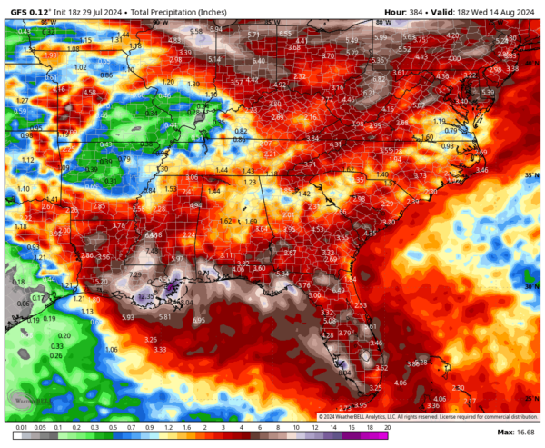
GFS RAINFALL AMOUNTS OVER THE NEXT TWO WEEKS
The graphic displayed below shows higher rainfall amounts along the Gulf Coast as it develops a subtropical low or weak tropical low that moves along the northern Gulf Coast in week two. The other global models are less bullish on the idea of a tropical cyclone hitting the US in the next two weeks.
POSSIBLE TROPICAL DEVELOPMENT NEAR THE BAHAMAS INTO GULF
An area of disturbed weather in the central Tropical Atlantic, located near 51 West Longitude, is being closely monitored. While current environmental conditions are not favorable for development, this disturbance could become more organized as it approaches the Turks and Caicos Islands later this week. Depending on its path, the system could move toward the East Coast or into the eastern Gulf of Mexico. The potential impacts range from a low-end tropical storm near Florida to more significant strengthening near North Carolina early next week. It does not appear to be a significant threat to the northern Gulf of Mexico coast, but we will be watching.
BEACH FORECAST
Along the beautiful Alabama and Northwest Florida beaches, expect mostly sunny skies with a chance of showers and thunderstorms through the week ahead and into the weekend. The surf height will be around 1 to 2 feet, with a low rip current risk. Water temperatures are in the upper 80s, providing warm conditions for beachgoers. Remember to heed local advisories and be aware of the rip current flag system. Check out our excellent beach forecasts. They can be accessed by the menu at the top of each page.
SPACEY STUFF: GEOMAGNETIC STORM WARNING ISSUED
The Space Weather Prediction Center (SWPC) has issued a geomagnetic storm warning for Tuesday. If G3 conditions are reached, auroras could be visible across mid-latitudes around 50°, including areas as far south as Illinois and Oregon. This presents a rare opportunity to witness the Northern Lights further south than usual. Not down into Alabama like in May, but still notable.
NATIONAL WEATHER: HAZARDOUS HEAT AND UNSETTLED WEATHER
A strong upper ridge over the central U.S. will bring unseasonably warm temperatures from the Plains to the Southeast. Later this week, upper ridging will build over the Northwest, leading to increasing heat, while a developing trough over the East may bring unsettled weather.
WEATHERBRAINS
In the latest episode of WeatherBrains, our team welcomes Dr. Sam Lillo, a Forecast Team/Senior Software Engineer at DTN, who holds a Masters and a PhD in Meteorology from the University of Oklahoma. Dr. Lillo shares his expertise in meteorology, offering unique insights into the challenges and advancements in weather forecasting. Don’t miss this engaging conversation—catch the episode on your favorite podcast platform like Apple Podcasts or Spotify, or listen directly on our website. Tune in for an informative and exciting discussion!
WISHFUL THINKING
On this date in 2014: An unusual upper level trough over the eastern United States delivered a refreshing shot of cool, dry air into the South. Record lows across Alabama included 57F at Birmingham, 54F at Anniston, 56F in Tuscaloosa, 56F in Hunstville and 55F at Muscle Shoals. The 59F at Montgomery was not only a record for the date, but it tied the all time record low for the month of July for Alabama’s capital city. It was 53F in Pinson and 49F at Crossville. Follow my weather history tweets on Twitter. I am @wxhistorian at Twitter.com.
Category: Alabama's Weather, ALL POSTS, Tropical


