
More Rain & Storms Today; The Heat Starts Building on Tuesday
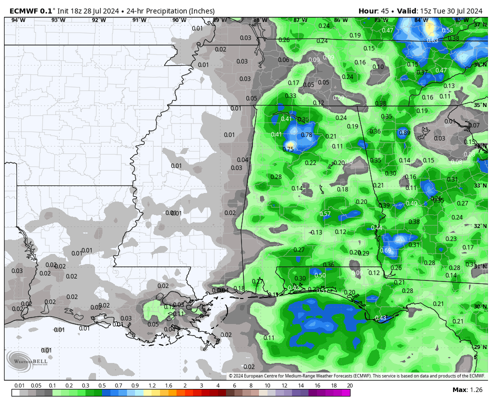
Projected rainfall totals for today (European Model).
RAIN CHANCES DECREASE; HEAT LEVELS INCREASE
This week, we’re experiencing a mix of weather patterns, with ridging to our west and troughing to our east and north, leading to waves of rain and storms across the area to start off the work week. Rain and storms will be more likely over the eastern half, while the west also sees a good chance of precipitation. Highs will range from the upper 80s to the lower 90s. On Tuesday, rain chances decrease slightly area-wide, but any activity that does form will primarily be over the eastern half. Unfortunately, the summer heat intensifies, with highs reaching the lower to mid-90s and heat indices potentially 10 degrees higher than the actual temperature.
By Wednesday, stronger ridging to our west will push daytime highs even higher, bringing increased heat. Though a few scattered showers and storms are possible, most locations will stay dry. Heat advisories are likely as high humidity makes temperatures in the mid to upper 90s feel like 105–109 degrees. Thursday will follow a similar pattern with high heat and humidity, and a small chance of scattered showers and storms in the afternoon. Highs will remain in the mid to upper 90s. This pattern continues into Friday, with very hot and humid conditions and only a small chance of afternoon showers and storms. Highs will stay in the mid to upper 90s.
A LITTLE COOLER FOR THE WEEKEND
As we move into the weekend, high temperatures will start to decrease on Saturday as a surface front approaches, increasing rain chances slightly and bringing highs down to the lower to mid-90s. These conditions will persist into Sunday, with the front lingering in the area, leading to scattered showers and storms and highs in the upper 80s to lower 90s.
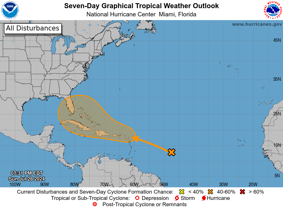
THE TROPICAL UPDATE
An area of disturbed weather over the central tropical Atlantic Ocean is expected to interact with an approaching tropical wave during the next couple of days. Environmental conditions are forecast to become conducive for some development thereafter, and a tropical depression could form mid to late week while the system is in the vicinity of the northern Leeward Islands, Greater Antilles, southwestern Atlantic Ocean, or the southeastern Bahamas. The formation chance through the next 48 hours is low, near 0 percent, but the formation chance through the next 7 days is medium, at 40 percent.
ON THIS DAY IN WEATHER HISTORY
1981 – Fifty cattle, each weighing 800 pounds, were killed by lightning near Vance AL. The lightning struck a tree and then spread along the ground killing the cattle.
SEVERE WEATHER SAFETY
Weather can be unpredictable, catching us off guard with its sudden changes. From thunderstorms to tornadoes or flash floods, being ready beforehand can be a lifesaver. Alabama, with its varied climate, faces its share of severe weather. That’s why having a solid safety plan is so important for everyone. Check out our Severe Weather Safety Guide for valuable tips on how to stay safe when severe weather is on the horizon.
BEACH FORECAST
Please visit our Beach Forecast Center page to access the most up-to-date weather and rip current forecasts for the beaches spanning from Fort Morgan to Panama City. On this platform, you can choose the forecast specific to the region you intend to visit, ensuring you have accurate and relevant information for your plans.
ADVERTISE ON THE BLOG
Ensure you don’t miss this opportunity! Allow us to tailor a bespoke package designed to meet the unique requirements of your organization. Our offerings are creative, flexible, and affordably priced. For further details and inquiries, please reach out to Bill Murray at (205) 687-0782.
E-FORECAST SIGN UP
Receive the Alabama Weather Blog’s comprehensive Seven-Day Forecast directly to your inbox via email, delivered twice daily. Recognized as the most detailed weather forecast accessible in Central Alabama, our service ensures you stay informed and prepared. Subscribe now to access this valuable resource at no cost!
Category: ALL POSTS
About the Author (Author Profile)
Scott Martin is an operational meteorologist, professional graphic artist, musician, husband, and father. Not only is Scott a member of the National Weather Association, but he is also the Central Alabama Chapter of the NWA president. Scott is also the co-founder of Racecast Weather, which provides forecasts for many racing series across the USA. He also supplies forecasts for the BassMaster Elite Series events including the BassMaster Classic.Subscribe
If you enjoyed this article, subscribe to receive more just like it.


