Rain & Storms at Times Through Tuesday; Back to Typical Summer Weather by End of the Week
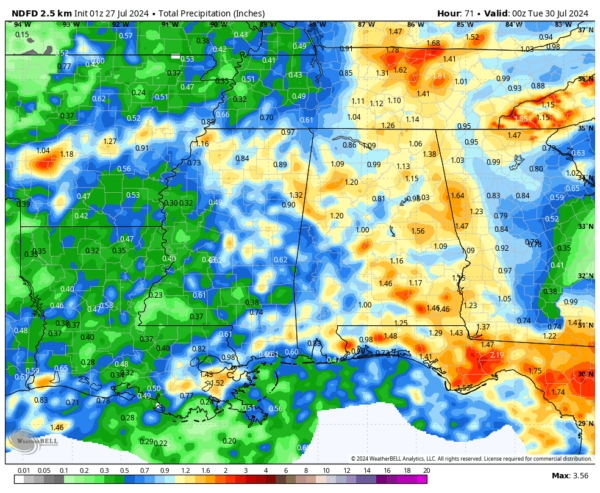
AN ACTIVE WEEKEND WITH A GOOD BIT OF RAIN & STORMS
We have a surface front that will begin to move into the northwestern parts of the area and progressing southeastward through the day today. Clouds will be on the increase from the west and scattered to numerous showers and storms will be likely as the front pushes through the area. Some heavy rain is possible, and a few flooding issues may happen thanks to poor drainage. No severe weather is expected, but I wouldn’t be surprised if we have a couple strong storms at some point. Highs in the mid 80s to the lower 90s.
We’ll start to have a ridge build over the southeast on Sunday that will eventually lead to smaller rain chances for the work week, but rain and storms will be likely at times throughout the day. Once again, severe weather is not likely, but a strong storm or two will be possible. Highs in the lower 80s to the lower 90s.
REMAINING ACTIVE THROUGH MIDWEEK
Rain and storms will once again be likely on Monday as an active pattern is still set up over the southeast. Highs in the mid 80s to the lower 90s. Tuesday will pretty much be a carbon copy of Monday, with highs in the upper 80s to the lower 90s.
On Wednesday, we start to see the ridge finally start to take control of our weather. Heat will begin to rise and rain and storm chances begin to fall. Scattered showers and storms are highly possible, but not likely as in the previous few days. Highs in the upper 80s to the mid 90s.
We get back to a weather pattern that we expect for this time of year on Thursday. Mostly sunny with a small chance of a few scattered showers and storms during the afternoon and early evening. Highs in the lower to mid 90s. And we’ll keep that trend going to end out the forecast period on Friday… Mostly sunny and hot with a few scattered showers and storms possible by afternoon. Highs in the lower to mid 90s.
THE TROPICAL UPDATE
Near the Lesser and Greater Antilles: An area of disturbed weather over the central tropical Atlantic Ocean is expected to interact with an approaching tropical wave during the next several days. Some development of this system is possible while it approaches the Lesser Antilles during the early to middle part of next week and moves generally west-northwestward near the Greater Antilles towards the latter part of the week. Looking into Voodoo Land, the GFS has picked up on this system and brings it into the Gulf of Mexico and making landfall near the Texas Louisiana state line on August 6th during the morning. However, we have a good while before the actual forecast track is determined, and we have to wait for the system to become better organized before that will happen. The European shows a system moving in the same general direction, but much weaker than the GFS. We are getting closer to the seasonal peak, so we’ll have to watch every disturbance out there.
ON THIS DAY IN WEATHER HISTORY
1987 — Thunderstorms in Minnesota spawned a tornado which moved in a southwesterly direction for a distance of thirty miles across Rice County and Goodhue County. Trees were uprooted and tossed about like toys, and a horse lifted by the tornado was observed sailing horizontally through the air. Thunderstorms drenched La Crosse WI with 5.26 inches of rain, their second highest 24 hour total of record.
SEVERE WEATHER SAFETY
Weather can be unpredictable, catching us off guard with its sudden changes. From thunderstorms to tornadoes or flash floods, being ready beforehand can be a lifesaver. Alabama, with its varied climate, faces its share of severe weather. That’s why having a solid safety plan is so important for everyone. Check out our Severe Weather Safety Guide for valuable tips on how to stay safe when severe weather is on the horizon.
BEACH FORECAST
Please visit our Beach Forecast Center page to access the most up-to-date weather and rip current forecasts for the beaches spanning from Fort Morgan to Panama City. On this platform, you can choose the forecast specific to the region you intend to visit, ensuring you have accurate and relevant information for your plans.
ADVERTISE ON THE BLOG
Ensure you don’t miss this opportunity! Allow us to tailor a bespoke package designed to meet the unique requirements of your organization. Our offerings are creative, flexible, and affordably priced. For further details and inquiries, please reach out to Bill Murray at (205) 687-0782.
E-FORECAST SIGN UP
Receive the Alabama Weather Blog’s comprehensive Seven-Day Forecast directly to your inbox via email, delivered twice daily. Recognized as the most detailed weather forecast accessible in Central Alabama, our service ensures you stay informed and prepared. Subscribe now to access this valuable resource at no cost!
Category: Alabama's Weather, ALL POSTS, Tropical, Weather Xtreme Videos


