Scattered Showers/Storms Later Today; Very Humid
**No morning video today**
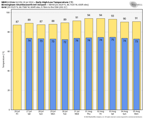
OCEAN OF HUMIDITY: Deep tropical moisture will remain in place across Alabama through the weekend, and scattered showers and thunderstorms will form again later today and early tonight. Rain should be a bit more scattered in nature today; the chance of any one spot seeing rain this afternoon is 40-50 percent. With a mix of sun and clouds expect a high in the mid to upper 80s.
Not much change is expected over the weekend; the sky will be occasionally cloudy tomorrow and Sunday with scattered to numerous showers and thunderstorms. Most, but not all, of the rain will come from noon to midnight. Stronger storms will produced heavy downpours, but the sun will break out at times. Highs over the weekend will be mostly in the mid 80s.
NEXT WEEK: Heat levels will creep up during the week as the upper ridge slowly rebuilds across the region. Afternoon highs will be in the low to mid 90s by the latter half of the week. Scattered showers and storms will remain a possibility on a daily basis… the higher coverage will likely come on Monday and Tuesday.
TROPICS: Again today the Atlantic basin remains very calm, and tropical storm formation is not expected for at least the next seven days.
ON THIS DATE IN 1931: A swarm of grasshoppers descends on crops throughout the American heartland, devastating millions of acres. Iowa, Nebraska, and South Dakota, already in the midst of a bad drought, suffered tremendously from this disaster.
ON THIS DATE IN 1979: Tropical Storm Claudette stalled over Alvin, Texas, inundating the town with 45 inches of rain in 42 hours. The total included 43 inches in 24 hours, which is the maximum 24-hour rainfall in American history.
Look for the next video briefing here by 3:00 this afternoon… enjoy the day!
Category: Alabama's Weather, ALL POSTS


