Midday Nowcast: Despite Recent Rains, Severe Drought Continues for Portions of Alabama
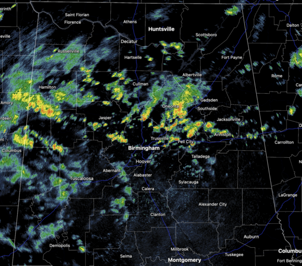
NEW DAY, SAME FORECAST: A tropical, unstable air mass remains in place across Alabama continues to allow for numerous showers and thunderstorms on the radar again today. Rain and storms are possible at anytime, but the majority of the showers and storms will come during the afternoon and evening hours. With high precipitable water values, stronger storms will be very efficient rain producers, and areas of isolated flash flooding continue to be possible; also, summer storms produce tremendous amounts of lightning. It won’t be raining all the time, and when it is not, expect the sun will peek out at times. But, with generally mostly cloudy conditions, daytime temperatures will remain below average, with highs in the upper 70s to mid 80s.
BIRMINGHAM ALMANAC: For July 25th, the average high for Birmingham is 91° and the average low is 73°. The record high is 106° set in 1952, while the record low is 60° set in 2019. We average 0.18” of precipitation on this date, and the record value is 1.49” set in 1922.
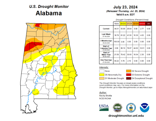
DROUGHT MONITOR: The beneficial rains over the last week have helped drought conditions to improve across portions of Alabama, but again, it takes a while for drought conditions to form, and it takes time for drought conditions to go away. For the southern two-thirds of the state, along and south of Interstate 20, we are just seeing pockets of Abnormally Dry conditions. North of Interstate 20, we are seeing Moderate Drought with Severe Drought affecting portions of Pickens, Tuscaloosa, Fayette, Walker, Winston, Marion, and Lamer counties, as well as Lauderdale, Limestone, Madison, and Jackson counties. We still have Extreme Drought conditions affection Lamar, Fayette, Walker and Marion Counties, as well as portions of Lauderdale County.
FRIDAY AND THE WEEKEND: Scattered rain and storms remain in the forecast tomorrow and through the weekend but by Saturday and Sunday, an upper ridge will try and build in across the region. This should cause a trend toward fewer showers and storms both days. Chance of any one spot seeing rain both days will be in the 40-50 percent, and with a mix of sun and clouds we expect highs to climb into the upper 80s and lower 90s.
NEXT WEEK: A more typical summer pattern is the story next week. Expect hot, humid days with scattered, mostly afternoon and evening showers and thunderstorms. Highs will be around 90° Monday and Tuesday, and climbing into the low and mid 90s for the rest of the week.
IN THE TROPICS: The Atlantic Basin is quiet and tropical cyclone development is not expected the next seven days. This is not unusual for this time of year as the core of hurricane season is late August through September, with the statistical peak around September 10th.
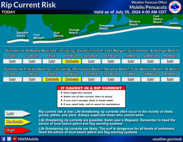
BEACH FORECAST CENTER: Numerous showers and storms are the beaches with high in the mid 80s. PLEASE pay attention to the Rip Current Flag System at each beach. Get the latest weather and rip current forecasts for the beaches from Fort Morgan to Panama City on our Beach Forecast Center page. There, you can select the forecast of the region that you are interested in visiting.
WORLD TEMPERATURE EXTREMES: Over the last 24 hours, the highest observation outside the U.S. was 120.9F at Kuwait International Airport, Kuwait. The lowest observation was -93.8F at Amundsen-Scott South Pole Station, Antarctica.
CONTIGUOUS TEMPERATURE EXTREMES: Over the last 24 hours, the highest observation was 120F at Topock, AZ. The lowest observation was 32F at Big Bay, MI.
Category: Alabama's Weather, ALL POSTS
About the Author (Author Profile)
Macon, Georgia Television Chief Meteorologist, Birmingham native, and long time Contributor on AlabamaWX. Stormchaser. I did not choose Weather, it chose Me. College Football Fanatic. @Ryan_StinnetSubscribe
If you enjoyed this article, subscribe to receive more just like it.


