
Midday Nowcast: Occasional Showers and Storms through Friday
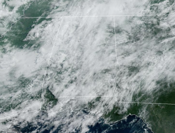
WET AT TIMES: The air remains unstable across Alabama this week, and we are forecasting scattered to numerous showers and thunderstorms on a daily basis each day through Friday. A majority of the showers and storms will come from noon to midnight, and with high precipitable water values, stronger storms will be very efficient rain producers; areas of isolated flash flooding will be possible. Also, summer storms produce tremendous amounts of lightning.
It won’t be raining all the time, and when it is not, expect the sun will peek out at times. But, with generally overcast conditions daytime temperatures will remain below average, with highs in the low to mid 80s most days.
BIRMINGHAM ALMANAC: For July 22nd, the average high for Birmingham is 91° and the average low is 73°. The record high is 100° set in 1993, while the record low is 55° set in 1947. We average 0.18” of precipitation on this date, and the record value is 2.92” set in 2006.
ACROSS THE USA: Dangerous heat continues across the West with widespread Excessive Heat Warnings and Heat Advisories. The West should see relief from hazardous heat by Friday. The heat will expand into the northern Plains on Tuesday. Heavy to excessive rainfall today in the Mid-Atlantic to Carolinas, southern Rockies, and west Texas into the ArkLaTex may lead to areas of flash, urban, and stream flooding.
WEEKEND WEATHER: An upper ridge will try and rebuild across the region, meaning a trend toward fewer showers and storms Saturday and Sunday. Chance of any one spot seeing rain both days will be in the 40-50 percent, and with a mix of sun and clouds we expect highs to climb into the upper 80s and lower 90s.
NEXT WEEK: A more typical summer pattern is the story for the week of July 29-August 2 with hot, humid days and “scattered, mostly afternoon and evening showers and thunderstorms”. Highs will be generally in the low 90s.
IN THE TROPICS: The Atlantic Basin is quiet and tropical cyclone development is not expected the next seven days.
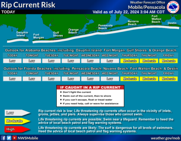
BEACH FORECAST CENTER: Numerous showers and storms are the beaches with high in the mid 80s. PLEASE pay attention to the Rip Current Flag System at each beach. Get the latest weather and rip current forecasts for the beaches from Fort Morgan to Panama City on our Beach Forecast Center page. There, you can select the forecast of the region that you are interested in visiting.
WORLD TEMPERATURE EXTREMES: Over the last 24 hours, the highest observation outside the U.S. was 120.9F at Kuwait International Airport, Kuwait. The lowest observation was -84.3F at Vostok, Antarctica.
CONTIGUOUS TEMPERATURE EXTREMES: Over the last 24 hours, the highest observation was 124F at Death Valley, CA. The lowest observation was 30F at Foxpark, WY.
Category: Alabama's Weather, ALL POSTS
About the Author (Author Profile)
Macon, Georgia Television Chief Meteorologist, Birmingham native, and long time Contributor on AlabamaWX. Stormchaser. I did not choose Weather, it chose Me. College Football Fanatic. @Ryan_StinnetSubscribe
If you enjoyed this article, subscribe to receive more just like it.


