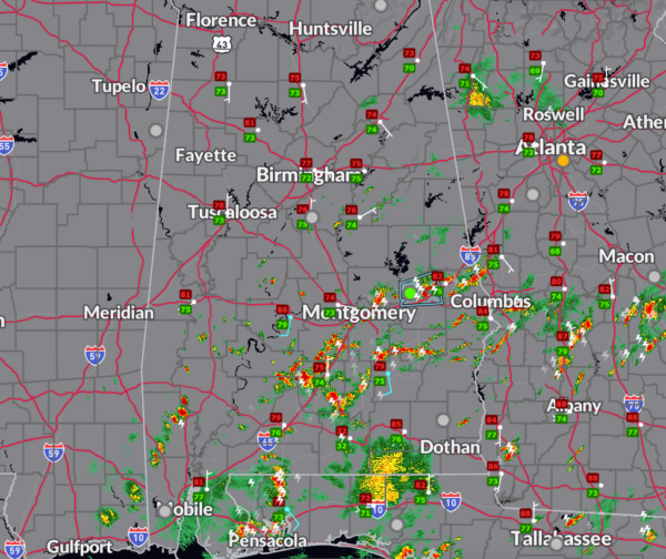
Morning Beneficial Rains in Many Areas; Strong Storms over South Alabama
Showers and storms started forming over eastern Mississippi after midnight. These grew into a large mass of rain and thunder that moved east northeast across Central Alabama during the pre-dawn and early morning hours.
The storms were sub-severe and generally brought beneficial rains to areas from Sumter, Greene, Hale, and Marengo counties northeast across Bibb, Tuscaloosa, Jefferson, Shelby, Chilton, St. Clair, Blount, Etowah, Talladega, Clay, Randolph, Cherokee, Calhoun, and Cleburne counties.
Later in the morning hours, showers and storms have blossomed across South Central Alabama to the south of the morning rain area. Those storms are numerous now over areas generally south of I-85. There is a strong storm in northern Macon County north of Talladega, moving toward Lee County and Auburn and Opelika.
It is mostly cloudy across the northern two thirds of the state, with sunshine beginning to increasingly peek through. This trend will continue, but the storms over the south will continue to grow.
Temperatures are in the 70s in the cloudier, rain-cooled areas with 80s where sunshine have prevailed. It is 86F at Selma and 85F at Enterprise at this hour. In the areas of increasing sunshine, highs will edge up into the 80s.
Widely scattered showers and storms will form over the northern two thirds of the state during the afternoon.
Another disturbance will likely move across tonight, with another area of showers and storms.
Category: Alabama's Weather, ALL POSTS, Severe Weather


