
Saturday Morning Briefing Video: Unusually Wet Week Ahead for Alabama
As we move deeper into July, Central and North Alabama are experiencing an unusually wet period for this time of year, driven by a persistent stationary front and broad troughing. Typically, summer in Alabama brings hot and relatively dry conditions, but we’re beginning to see an influx of moisture from the Gulf, leading to frequent showers and thunderstorms. This pattern is expected to continue into the next week, with daily rain chances ranging from 60-70%, particularly in the afternoon and evening. This will help to keep temperatures in check, with highs mostly in the 80s and lows in the upper 60s to lower 70s. While the rain is welcome to alleviate any developing drought conditions, it also brings the risk of locally heavy downpours and potential flooding in some areas. Let’s dig into the details.
YESTERDAY: An amplified weather pattern remained over much of the country, with a strong mid-level ridge over the Four Corners states and a mid-level trough over the Mid-South region affecting our local weather. Early in the afternoon, a shortwave over Northeast Alabama brought showers to our northern and eastern counties, while another shortwave over East-Central Mississippi and a disturbance over far Southwest Mississippi influenced our weather. A diffuse surface front extended from near Houston, Texas, northeastward to Atlanta and the Carolinas, while high pressure was analyzed over the Midwest and Ohio River Valley. Through mid-afternoon, scattered showers moved northeast, primarily affecting northern and eastern counties, with a temporary break in activity across the southwest counties. By late afternoon, scattered to numerous showers and thunderstorms developed, especially across the southern half of the area. Winds were from the southwest at 4-8 mph, with high temperatures ranging from around 80°F in the northwest to the upper 80s near and south of the U.S. Highway 80 corridor.
More disturbances moved northeast over the area, resulting in continued mid and upper-level support for lingering showers and a few storms overnight. The diffuse surface front stalled across the area before lifting back northward as a warm front. Higher rain chances were noted along the Interstate 20 corridor. Training activity required monitoring for potential localized water ponding and pooling in poor drainage areas. Mostly cloudy skies persisted overnight with lingering showers and some thunderstorms. Patchy fog developed in the northern portions before sunrise on Saturday. Winds shifted to the southeast at 3-6 mph, with low temperatures ranging from the upper 60s in the north to the low 70s in the south.
THE UPPER PATTERN ACROSS NORTH AMERICA: The upper level trough responsible for the wetter weather over Alabama and the Deep South will remain in place until midweek. By the end of the week, the trough will retrograde (move westward) and begin weakening by the weekend. By then, an extension of the subtropical ridge to the east of Alabama over the Atlantic will intensify over us. The second ridge will remain in place over the Deep South until the latter part of week two. How will this overall pattern affect us? Let’s see.
FOR YOUR SATURDAY: That stationary front and a very moist airmass will keep the weather pattern wet with off-and-on waves of convection. Expect mostly cloudy skies with frequent showers and thunderstorms, especially in the afternoon and evening. Highs will reach around 85°F, and overnight lows will drop to about 70°F. Locally heavy downpours are possible, with rainfall amounts ranging from 0.07 to 0.51 inches. Winds will be light, primarily from the southeast at 3-5 mph.
TOMORROW: The wet pattern continues as broad troughing from the Great Lakes to ArkLaTex allows for significant moisture flow and upper-level support for thunderstorms. Expect a 70-80% chance of thunderstorms, primarily in the afternoon and evening, with highs around 84°F and lows near 70°F. Rainfall amounts will range from a quarter to one half inch.
NEW WORK WEEK: The rainy pattern persists, with high moisture levels and upper-level disturbances driving thunderstorm activity. Expect a 60-70% chance of afternoon and evening thunderstorms. Highs will be around 85°F, with lows near 69°F. Rainfall amounts will range from a quarter to one half inch.
MIDWEEK: High rain chances continue through midweek as the broad trough remains over the area. Expect a 60-70% chance of afternoon and evening thunderstorms each day, with highs around 85-86°F and lows near 69-70°F. Winds will be light, predominantly from the south-southwest. Rainfall amounts will again range from a quarter to one half inch. with widespread afternoon and evening thunderstorms expected.
INTO THE WEEKEND: High rain chances continue into the weekend with widespread afternoon and evening thunderstorms expected both days. Rain chances will be around 60-70%. Highs will be in the mid to upper 80s, with overnight lows in the upper 60s to lower 70s. Locally heavy downpours are still possible.
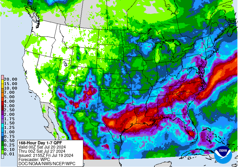
7 DAY QPF: There will be a band of 2-3 inch amounts across Central Alabama in the next 7 day, with amounts tapering to the north and south, with 1-2 inches on either side through North and South Alabama. Only the southeast corner of the state will get less.
VOODOO TERRITORY: The start of the following week should see a continuation of above-normal rain chances, though there may be some variability as more detailed model guidance becomes available. The consistent troughing pattern and ample moisture flow suggest that daily thunderstorm activity will remain a feature, with temperatures continuing to be moderated by cloud cover and rainfall, staying mostly in the 80s to low 90s.
TROPICAL WEATHER UPDATE: The Atlantic, Caribbean, and Gulf of Mexico remain quiet with no areas of interest. Tropical development is not expected across the Atlantic Basin this weekend and into at least next week. It’s plausible that we’ll stay quiet with no tropical development through the end of this month. This calm period is due to a downward motion pulse of the Madden Julian Oscillation and significant dust and stable air from the Saharan Air Layer, creating an environment generally unfavorable for development.
Currently, we are in peak dust season, which is quite normal. Over the next 2 to 3 weeks, the amount of dust and dry air across the tropical Atlantic will decrease, leading to a more favorable environment for tropical systems. The next upward motion pulse of the Madden Julian Oscillation is expected to enter the Atlantic Basin during the first half of August, creating an atmospheric background state with more moisture, instability, and forcing conducive to tropical development.
Model guidance indicates increased chances for tropical development starting in early August, with a significant increase in activity expected by or just before August 10. This pattern is expected to bring a busy period of tropical activity that could last through August, September, and October. The extended range European model forecasts increased chances for development during the week of August 12 between the Lesser Antilles and the coast of Africa. While the CFS model hints at earlier activity, it is likely that the Atlantic will become very active by mid-August.
BEACHCAST: This weekend and into early next week, the beautiful beaches of Alabama and Northwest Florida, including Gulf Shores, Orange Beach, Pensacola Beach, Gulf Breeze, Navarre Beach, Fort Walton Beach, and Destin, will experience mostly cloudy conditions with frequent showers and thunderstorms. Today, the weather remains mostly cloudy with continued showers and thunderstorms, highs in the upper 80s, and southwest winds around 10 mph. The rip current risk will stay low through the weekend, with surf heights maintaining at 1 to 2 feet. Saturday night will see partly cloudy skies with more showers and thunderstorms, lows in the lower 80s, and southwest winds around 10 mph. Sunday will bring partly sunny skies with showers and thunderstorms, highs in the upper 80s, and southwest winds around 10 mph. The pattern continues into Monday and Tuesday, with mostly sunny skies and frequent showers and thunderstorms. Surf heights will be around 1 to 2 feet, and temperatures will stay in the upper 80s. Rip current risk remains low, but always exercise caution, particularly near groins, jetties, reefs, and piers. Enjoy the beaches while staying weather-aware and safe.
NATIONAL WEATHER: A broad trough over the central United States is bringing widespread showers and thunderstorms from the Great Lakes to the Gulf Coast, with particularly heavy rainfall and potential flooding in the Mississippi Valley and Southern Plains. The Four Corners region remains under the influence of a strong ridge, maintaining hot and dry conditions across the Southwest. The Pacific Northwest and Northern Rockies will experience cooler temperatures and scattered showers due to a passing frontal system. Meanwhile, the Southeast and Eastern Seaboard are dealing with typical summer heat and humidity, punctuated by isolated thunderstorms.
ON THE RECORD: 91F at Stanley ID day was a record for the date.
WEATHERBRAINS: Join us Monday night as we celebrate the new Twisters movie with the actual producers! www.WeatherBrains.com or wherever you get your podcasts. Live at youtube.com/weatherbrains.
WEATHER HISTORY: ”Houston, Tranquility Base here, the Eagle has landed.” The lunar module of Apollo 11 landed on the moon on the afternoon of Sunday, July 20, 1969 at 3:17 p.m. CDT. We were mesmerized six hours and 39 minutes later when Neil Armstrong became the first man to walk on the moon. It was hot and humid across Central Alabama. The high at Birmingham was 95F, after a morning low of 70F. The airport recorded 0.05″ of rain.
Category: Alabama's Weather, ALL POSTS, Tropical
About the Author (Author Profile)
Bill Murray is the President of The Weather Factory. He is the site's official weather historian and a weekend forecaster. He also anchors the site's severe weather coverage. Bill Murray is the proud holder of National Weather Association Digital Seal #0001 @wxhistorianSubscribe
If you enjoyed this article, subscribe to receive more just like it.


