
Midday Nowcast: Hot Days with Increasing Humidity
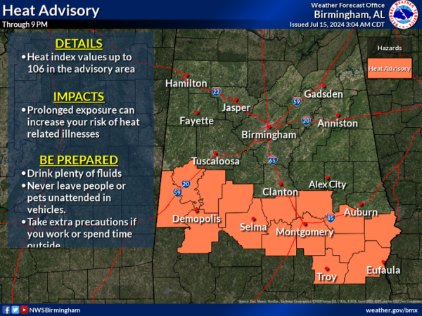
MORE ROUTINE SUMMER WEATHER: A mix of sun and clouds, hot and humid weather, with scattered showers and storms mainly during the afternoon and evening hour is the forecast today and tomorrow. Highs both days will generally be in the mid 90s. Rain and storms will develop, with the highest coverage in the 3-10PM time frame. Big heat, means big storms and summer storms produce tremendous amounts of lightning, gusty winds, and heavy rainfall. We also note a Heat Advisory has been issued for the southern half of the state.
BIRMINGHAM ALMANAC: For July 15th, the average high for Birmingham is 91° and the average low is 72°. The record high is 102° set in 1980, while the record low is 51° set in 1967. We average 0.18” of precipitation on this date, and the record value is 2.00” set in 1923.
ACROSS THE USA: Excessive heat will affect the center and eastern portions of our country today with numerous record highs are expected. The combination of heat and humidity, along and ahead of cold front, will focus showers and thunderstorms. Storms could be severe from the western High Plains, Midwest into the Great Lakes region; Locally heavy rainfall may result in isolated instances of flash flooding.
HIGHER RAIN CHANCES: Showers and storms will begin to increase in coverage Wednesday as the air becomes more unstable, and by Thursday and Friday we expect numerous showers and storms. As always in summer, rain distribution won’t be very even, but the chance of rain for your front yard is 50-60 percent Wednesday, and near 70 percent Thursday and Friday. The showers and storms will be a welcomed sight to a very dry and Alabama. With the clouds and higher rain chances, afternoon highs will drop back into the mid and upper 80s Thursday and Friday.
THE ALABAMA WEEKEND: The weather stays unsettled with a good chance of occasional showers and thunderstorms Saturday and Sunday. The weekend won’t be a wash-out by any means, but rain is likely at times with highs only in the mid 80s. Again, rainfall distribution will remain very uneven across the state. This pattern will continue into next week and typical late July weather will be the story.
IN THE TROPICS: The Atlantic Basin is quiet and tropical cyclone development is not expected the next seven days.

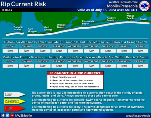
BEACH FORECAST CENTER: Highs in the low 90s along the beaches, with upper 90s just inland. Expect storms on a daily basis and water temperatures are in the mid to upper 80s up and down the Northern Gulf Coast. PLEASE pay attention to the Rip Current Flag System at each beach. Get the latest weather and rip current forecasts for the beaches from Fort Morgan to Panama City on our Beach Forecast Center page. There, you can select the forecast of the region that you are interested in visiting.
WORLD TEMPERATURE EXTREMES: Over the last 24 hours, the highest observation outside the U.S. was 120.0F at Ouargia, Algeria. The lowest observation was -89.7F at Amundsen-Scott South Pole Station, Antarctica.
CONTIGUOUS TEMPERATURE EXTREMES: Over the last 24 hours, the highest observation was 121F at Death Valley, CA. The lowest observation was 35F at Bynum, MT.
Category: Alabama's Weather, ALL POSTS
About the Author (Author Profile)
Macon, Georgia Television Chief Meteorologist, Birmingham native, and long time Contributor on AlabamaWX. Stormchaser. I did not choose Weather, it chose Me. College Football Fanatic. @Ryan_StinnetSubscribe
If you enjoyed this article, subscribe to receive more just like it.


