
Midday Nowcast: Hot and Getting Hotter
HOT, HOT, HOT: Highs today are in the mid 90s with plenty of sunshine in the Alabama sky and it will remain a dry day across the northern half of the state. For the weekend, we are forecasting generally rain-free days with a good supply of sunshine both days. We will mention just a small risk of a shower both days, but rain chances are less than 20%. The main story this weekend will be the temperatures, as upper 90s and low 100s are expected across Alabama.
BIRMINGHAM ALMANAC: For July 12th, the average high for Birmingham is 91° and the average low is 72°. The record high is 106° set in 1930, while the record low is 58° set in 1975. We average 0.18” of precipitation on this date, and the record value is 3.14” set in 1961.
USA BRIEF: Showers and thunderstorms may produce heavy to excessive rainfall along the east coast today. The associated rainfall will likely create localized areas of flash and urban flooding. An extremely dangerous heat wave will shift into portions of the central and eastern U.S. late this weekend, lasting through the next work week. Widespread daily record high temperatures are expected.
NEXT WEEK: The week starts off hot and mainly dry with highs in the upper 90s. Humidity levels will gradually increase and heat index values will begin to approach the danger range once again, meaning we could see more heat advisories. For the second half of the week, moisture levels climb fast and our rain chances will increase. Expect numerous showers and storms to return to the Alabama by Thursday and Friday. With higher rain chances, heat levels should come down some, but we are still forecasting low to mid 90s.
IN THE TROPICS: The feature off the Southeastern U.S. Coast will not develop and will bring heavy rainfall to the Carolinas this weekend. The rest of the Atlantic Basin is quiet and tropical cyclone development is not expected the next seven days.
BEACH FORECAST CENTER: Highs in the low 90s along the beaches, with upper 90s just inland. Expect storms on a daily basis and water temperatures are in the mid to upper 80s up and down the Northern Gulf Coast. PLEASE pay attention to the Rip Current Flag System at each beach.
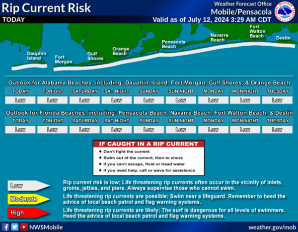
Get the latest weather and rip current forecasts for the beaches from Fort Morgan to Panama City on our Beach Forecast Center page. There, you can select the forecast of the region that you are interested in visiting.
WORLD TEMPERATURE EXTREMES: Over the last 24 hours, the highest observation outside the U.S. was 124.3F at Ahwaz, Iran. The lowest observation was -100.3F at Vostok, Antarctica.
CONTIGUOUS TEMPERATURE EXTREMES: Over the last 24 hours, the highest observation was 127F at Death Valley, CA. The lowest observation was 31F at Peter Sinks, UT.
Category: Alabama's Weather, ALL POSTS
About the Author (Author Profile)
Macon, Georgia Television Chief Meteorologist, Birmingham native, and long time Contributor on AlabamaWX. Stormchaser. I did not choose Weather, it chose Me. College Football Fanatic. @Ryan_StinnetSubscribe
If you enjoyed this article, subscribe to receive more just like it.


