
Showers/Storms More Numerous Tomorrow
RADAR CHECK: We have our classic case of random, scattered showers and thunderstorms across Alabama this afternoon. They are moving northward; some spots are seeing a good downpour. But, away from the showers, it is a hot, humid afternoon with temperatures in the 90s. We will maintain the chance of a few scattered showers through the night tonight with a low in the 70s.
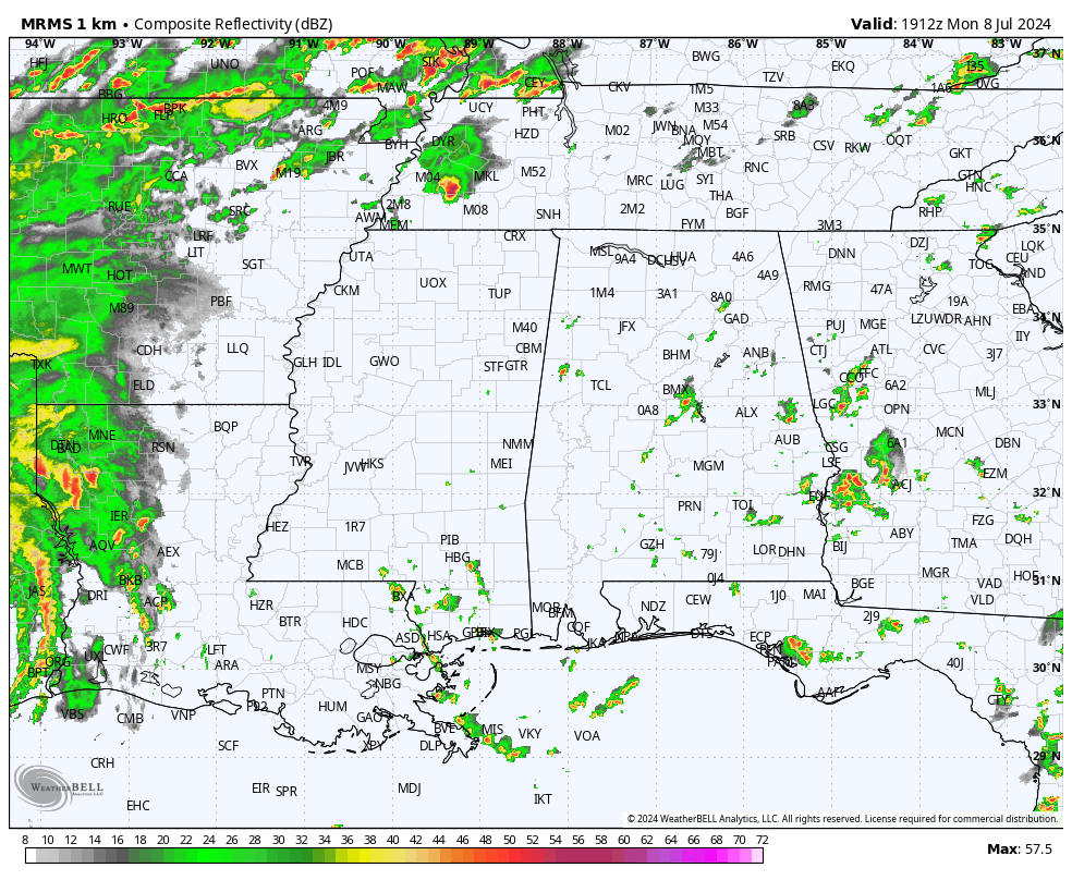
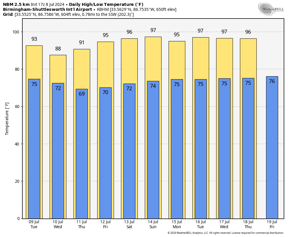
Coverage of showers and storms will be higher tomorrow as deeper tropical moisture moves into the state south of the remnant circulation of Beryl, which will be passing through the Ohio Valley. Chance of your front yard seeing rain tomorrow is 60-70 percent, and it will be the wettest day of the week. The high tomorrow will be in the 88-93 degree range.
REST OF THE WEEK AND THE WEEKEND: A drier airmass will be pulled into Alabama Wednesday; we will mention just a small risk of a stray shower with a high only in the upper 80s for the northern half of the state. Lower humidity levels will make for a pleasant summer day.
At this point, it looks like most of the state will be dry Thursday through Saturday with mostly sunny days and fair nights. Highs will be in the 90s, but humidity levels will be fairly low for July. We will bring back the chance of a few widely scattered showers or storms Sunday as moisture levels begin to rise, but most places will stay dry.
NEXT WEEK: For now the weather looks very routine for mid-summer. Partly sunny, hot, humid days with “scattered, mostly afternoon and evening showers and thunderstorms” on a daily basis. Highs in the 90s, lows in the 70s. See the video briefing for maps, graphics, and more details.
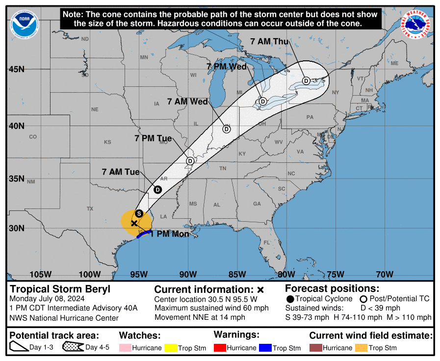
BERYL INLAND AND WEAKENING: Beryl made landfall on the Texas coast about 80 miles southwest of Houston early this morning with sustained winds of 80 mph. Winds have now decreased to 60 mph; the circulation center is just west of Lufkin, Texas at mid-afternoon. Beryl should turn northeastward and accelerate across the lower Mississippi Valley into the Ohio Valley during the next couple of days until dissipation occurs by Wednesday night.
The rest of the Atlantic basin is very quiet, and tropical storm formation is not expected at least for the next seven days.
ON THIS DATE IN 1680: The first confirmed tornado death in the United States occurred in Cambridge, Massachusetts. The funnel was filled with, stones, bushes, and other things. The tornado also unroofed a barn and snapped many large trees.
ON THIS DATE IN 1916: After the unnamed hurricane moved inland just west of Mobile on July 5, it moved into Central Alabama and essentially stalled, dumping 8.84” of rain on Birmingham, contributing to the city’s wettest month of all time at 20.16”.
ON THIS DATE IN 2005: Dennis struck Granma Province, Cuba, as a Category 4 hurricane. It would move into the Florida Panhandle two days later, on July 10.
ON THIS DATE IN 2009: An intense cold front brings heavy snow, hail, high winds and unusually cold temperatures to southern Peru. The severe conditions were blamed for the deaths of more than 246 children due to cold-related illnesses.
Look for the next video briefing here by 6:00 a.m. tomorrow…
Category: Alabama's Weather, ALL POSTS, Weather Xtreme Videos
About the Author (Author Profile)
James Spann is one of the most recognized and trusted television meteorologists in the industry. He holds the AMS CCM designation and television seals from the AMS and NWA. He is a past winner of the Broadcast Meteorologist of the Year from both professional organizations.Subscribe
If you enjoyed this article, subscribe to receive more just like it.


