
A Complete Look at Beryl Along with Alabama’s Weather for the Week Ahead
Good morning everyone! I am in Port Lavaca, Texas this morning exploring the Matagorda Bay area, where Beryl is expected to become a hurricane and make landfall in the next 36 hours. I will be reporting on my observations.
THE LATEST ON BERYL: The center of Tropical Storm Beryl is 240 miles southeast of Port Lavaca. The storm is moving to the west northwest, but gradually will be turning to the north northwest over the next 24 hours. Top winds are now around 60 mph. The storm is expected to increase in strength during the day, becoming a hurricane this evening, and increasing to 85-90 mph before landfall on Matagorda Island south of Palacios during the early morning hours on Monday.
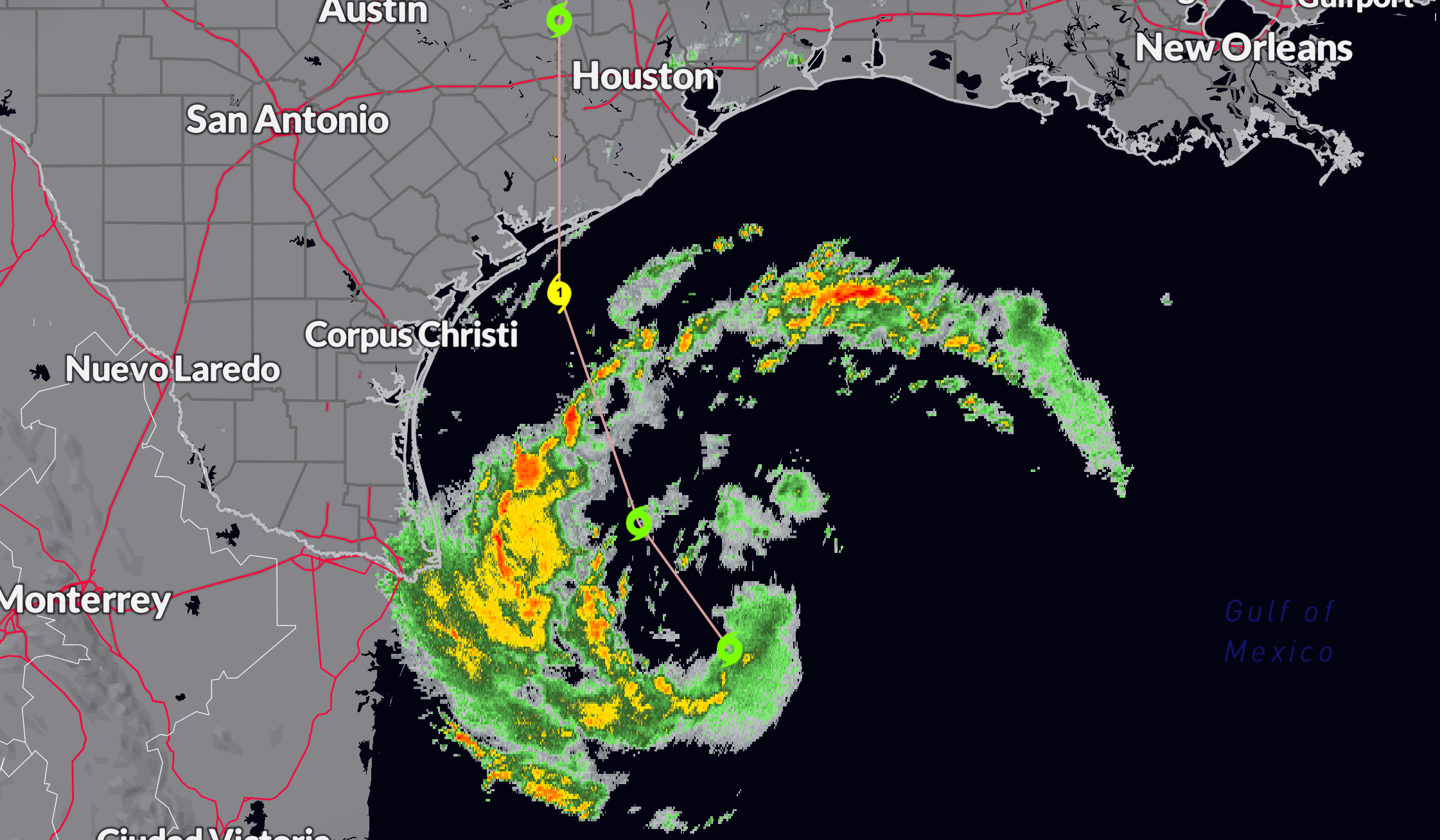
WIND THREATS: Tropical storm force winds will be arriving onshore tomorrow evening in the warning areas. Generally from northern Padre Island to Freeport. Then overnight, they will spread northward to Galveston and western parts of Houston by sunrise. Strong tropical storm force winds will arrive onshore between Matagorda Island and Freeport after midnight, spreading inland up to I-10 around LaGrange. The hurricane force winds and eyewall will move onshore around 4 a.m. along Matagorda Island, spreading inland with the eye passing over Port Lavaca or Bay City during the morning hours. Of course, any deviation could change this track substantially, and we will be updating it very six hours through landfall. Winds will be 85-90 mph at landfall, perhaps substantially higher. The storm should drop below hurricane force by noon, but will still bring strong tropical storm force winds and tropical storm force winds north to College Station and perhaps Groesbeck Monday night.
THE STORM SURGE THREAT: Peak storm surge will register 4-6 feet between Mesquite Pass east of Corpus Christi. That will be bookended by 3-5 foot surge as far wast as High Island and as far west as the North Entrance to the North Padre Island National Seashore. Beyond that, 2-4 feet of surge will extend as far east as Sabine Pass and west as far as the Rio Grande. 1-3 feet is expected as far wast as Cameron, LA.
RAINFALL THREATS: A large area of 4+ inch amounts will extend from the Texas Coastal Plain from Corpus Christi to Houston extending inland just east of the I-35 Corridor to Texarkana and into Arkansas. There is a moderate flash flood threat in this area.
TORNADO THREATS: Tornadoes will be possible in the outer rain bands of Beryl starting later this morning and afternoon along the Texas Coastal Plain from east of Corpus Christi to Port Arthur and inland to Victoria and Houston.
RIP CURRENT THREATS: Rip current threats are extreme along the Texas coast and high all the way through the Florida Panhandle, including the Alabama and Northwest Florida coasts. That situation will last through at least Sunday for our beaches and through Monday for the ones in Texas and Louisiana.
SATURDAY RAINFALL: Was quite scattered across North and Central Alabama yesterday. A few lucky locations across southern Jefferson County and northern Shelby County got lucky with near two inches, including my house, where I measured 1.89 inches. Areas around Sylacauga got as much as 4 inches.
FOR YOUR SUNDAY: A boundary lies across South Alabama on this Sunday and that is where the focus will be for showers and storms in Alabama today. They may get a little help with the overall flow around Beryl well to the west of us though. DOn’t expect them to be very widespread, although a few lucky spots could get some heavy rian.
THE WEEK AHEAD: Showers and storms will be scattered on Monday and Tuesday as some convergence from the remnants of Beryl works on the moisture over the state. That will disappear Wednesday through Friday as slightly drier air works in the state on the back side of Beryl’s departing circulation.
BEACHCAST: Rip currents are the issue through tonight and perhaps Monday. Stay out of the water along the beautiful beaches of Alabama and Northwest Florida. Some of our deadliest days at the beaches come with far away storms to our west.
Click here to see the Beach Forecast Center page.
DANCING WITH THE STATS: 106F at Raleigh, NC on Friday was an all-time record for the location. It was a daily record for July 5th by 4 degrees. The previous all-time record high was 105F set a few times in the past.
WEATHERBRAINS: This week, the panel will entertain Weather Channel Charles Peak. He may be with me live! Lots of the latest knowledge on severe weather will be shared. Check out the show at www.WeatherBrains.com. You can also subscribe on iTunes. You can watch the show live on our new YouTube channel for the show and you can see the live show on the James Spann 24×7 weather channel on cable or directly over the air on the dot 2 feed.
ON THIS DATE IN 1977: At 7 a.m. on 7/7/77, it was 77F at Birmingham with a RH of 77%. All those 7’s did not turn out to make for a lucky day in the Magic City however, as the high reached a sizzling 105F, the hottest since 1952. Follow my weather history tweets on Twitter. I am @wxhistorian at Twitter.com.
Category: Alabama's Weather, ALL POSTS, Tropical
About the Author (Author Profile)
Bill Murray is the President of The Weather Factory. He is the site's official weather historian and a weekend forecaster. He also anchors the site's severe weather coverage. Bill Murray is the proud holder of National Weather Association Digital Seal #0001 @wxhistorianSubscribe
If you enjoyed this article, subscribe to receive more just like it.


