
Scattered Showers & Storms Starting to Fire Up; The Latest on Beryl
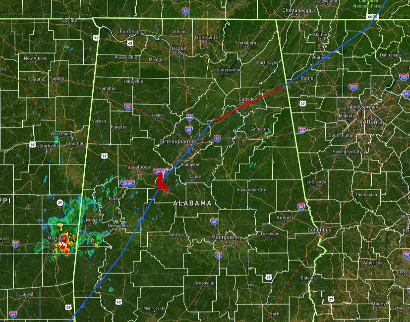
AT MIDDAY: On radar, we see a cluster of rain and storms over Meridian, Mississippi, and is moving into Sumter County, which already have a few showers and storms. We also see some pockets of rain dotting the screen, especially close to Anniston. For now, much of the area is dry with temperatures in the lower 80s to the lower 90s across Central Alabama. The warm spot is Talladega at 90º, while the cool spot is Haleyville at 80º. Birmingham was sitting at 89º.
THIS WEEKEND: Skies will continue to be partly to mostly sunny for the northern half of the area with only a small to medium chance of scattered showers and storms, while rain and storms will be likely south of the I-20 corridor. We will not get that much heat relief as winds will be light. Highs will top out in the lower to mid 90s. It will almost be the same exact forecast for Sunday, as rain and storms will continue to be likely south of I-20, with a small to medium chance of scattered showers and storms north of that. Once again, winds will be light, and highs will be in the lower to mid 90s.
THE WORK WEEK AHEAD: More tropical moisture will be pushed up into Central Alabama from the gulf on Monday, which will make our rain and storm chances likely at times, especially with the heating of the day. It will be very humid, making those highs in the lower to mid 90s just plain awful. On Tuesday, cloud cover along with more scattered to numerous storms will help bring our afternoon highs down just a few degrees, but humidity will remain very high, and we will still be wearing the air. Rain and storms will be likely at times, and highs will be in the upper 80s to the lower 90s. Rain chances will be a little less on Wednesday, but scattered showers and storms will continue to be in the forecast, especially for the afternoon and early evening. Highs in the lower 80s to the lower 90s.
High temperatures start to increase on Thursday, as our cloud cover and rain chances decrease. Skies will be partly to mostly sunny, and we’ll only have a small chance of an isolated to scattered shower or storm. Highs in the mid 80s to the lower 90s. And Friday will nearly be a carbon copy of Thursday, except for temperatures reaching the upper 80s to the mid 90s. Skies will be partly to mostly sunny, with only a small chance of an afternoon shower or storm.
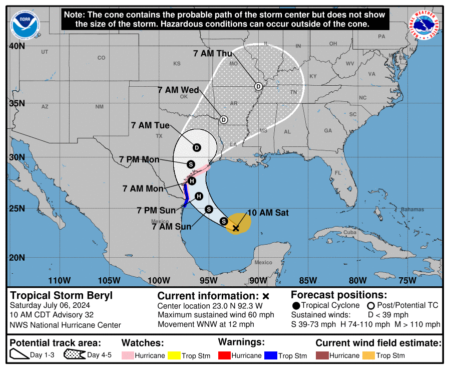
THE TROPICS: Tropical Storm Beryl is showing signs of intensification. A recent burst of convection near its center has helped the storm become better vertically aligned. Reports from Hurricane Hunter aircraft indicate a central pressure of 997 mb and severe turbulence within the storm. Beryl’s sustained winds remain at 60 mph. The storm is currently moving northwest at 12 mph and is expected to turn north, making landfall on the Texas coast within the next 48–60 hours. After landfall, it is projected to weaken and become a remnant low-pressure area within five days. There is a high risk of damaging hurricane-force winds and life-threatening storm surges along the Texas coast late Sunday into Monday. Flash flooding is likely in the Texas Gulf Coast and eastern Texas, and dangerous rip currents are expected along the Gulf Coast.
Category: Alabama's Weather, ALL POSTS, Tropical
About the Author (Author Profile)
Scott Martin is an operational meteorologist, professional graphic artist, musician, husband, and father. Not only is Scott a member of the National Weather Association, but he is also the Central Alabama Chapter of the NWA president. Scott is also the co-founder of Racecast Weather, which provides forecasts for many racing series across the USA. He also supplies forecasts for the BassMaster Elite Series events including the BassMaster Classic.Subscribe
If you enjoyed this article, subscribe to receive more just like it.


