Saturday Briefing — Scattered Storms Possible Through the Weekend; Tropical Moisture Invades Through Midweek
For today, it will be a little less muggy along and north of the I-20 corridor, as a surface boundary will have stalled out just south of that. Scattered showers and storms will be possible over those southern locations, while the northern locations will stay mainly dry. It will still be hot, no matter what, with highs in the lower to mid 90s. Tropical moisture begins to move in on Sunday, and rain chances will increase for all of Central Alabama. We can expect partly sunny skies with scattered, mainly afternoon and evening showers and storms possible. Highs in the lower 90s.
Moisture levels continue to increase and so do those rain chances on Monday. Showers and storms will be likely at times, especially during the afternoon and evening. Highs in the upper 80s to the lower 90s. Very close to the same story for Tuesday. Showers and storms will be likely at times, especially during the latter half of the day. Highs in the upper 80s to the lower 90s. Rain chances drop slightly on Wednesday, but we’ll keep scattered, mainly afternoon and evening showers and storms possible. Highs in the mid 80s to the lower 90s. Then, we’ll get back to the summer pattern that we are used to for Thursday. It will be partly to mostly sunny with a small chance for isolated to scattered showers and storms. Highs in the upper 80s to the mid 90s. We’ll go a couple of degrees hotter on Friday while keeping the small chance of isolated to scattered afternoon showers and storms. Highs in the lower to mid 90s.
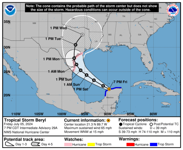
As of 8pm Friday evening, Tropical Storm Beryl was about to move over the Gulf of Mexico, and hurricane and storm surge watches are now in effect for parts of northeastern Mexico and Texas. As of 7 PM CDT, Beryl is located at 21.3N 89.7W, just east of Progreso, Mexico, and about 580 miles ESE of Brownsville, Texas. The storm is moving west-northwest at 15 mph, with maximum sustained winds of 65 mph and a minimum central pressure of 994 mb.
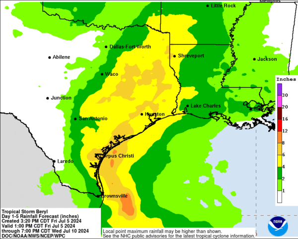
Beryl’s tropical-storm-force winds extend up to 105 miles from the center. It is expected to regain hurricane status on Sunday and bring heavy rainfall of 5 to 10 inches to parts of the Texas Gulf Coast and eastern Texas, with some areas potentially seeing up to 15 inches. This could lead to flash and urban flooding. Large swells from Beryl are impacting the Yucatán Peninsula and are expected to reach the Gulf Coast of the U.S. by early Saturday, causing life-threatening surf and rip currents.
Category: Alabama's Weather, ALL POSTS, Tropical, Weather Xtreme Videos


