
Mid-Morning Nowcast: Heat with Scattered Storms
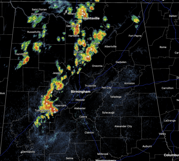
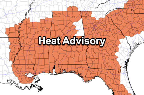
Scattered showers and storms are ongoing across North and Central Alabama. These storms are producing very heavy rainfall and frequent lightning. The radar will remain busy today as additional showers and storms will continue to develop. The chance of any one spot getting wet will be in the 60/70 percent range, but still it won’t rain everywhere. Highs will remain in the mid to upper 90s. A heat advisory continues for most of Alabama today as heat index values will be in the 105°-109· range.
Drier air drops into the state tomorrow and Sunday with showers and storms becoming more isolated in nature. Highs will remain in the low to mid 90s.
BIRMINGHAM ALMANAC: For July 5th, the average high for Birmingham is 91° and the average low is 72°. The record high is 100° set in 1948, while the record low is 58° set in 2014. We average 0.17” of precipitation on this date, and the record value is 1.68” set in 1915.
NEXT WEEK: Moisture levels will begin to increase and we will roll with a persistence forecast. It will be hot, humid, with those daily showers and thunderstorms around mainly during the afternoon and evening hours. Expect highs in the 90s and lows in the 70s.
IN THE TROPICS: Hurricane Beryl made landfall this morning near Tulum, Mexico. Beryl is moving toward the west-northwest near 15 mph. A west-northwestward motion is expected during the next day or so, with the center expected to cross the northern Yucatan Peninsula today.Beryl is expected to emerge over the southwestern Gulf of Mexico tonight and then move northwestward toward northeastern Mexico and southern Texas by the end of the weekend.
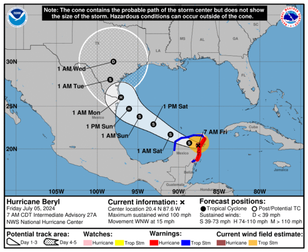
Maximum sustained winds have decreased to near 100 mph with higher gusts. Rapid weakening is expected as Beryl moves farther inland and crosses the Yucatan Peninsula today, but slow re-intensification is expected once Beryl moves back over the Gulf of Mexico. The estimated minimum central pressure is 980 mb (28.94 inches).
The rest of the basin is quiet.
BEACH FORECAST CENTER: Highs in the upper 80s and low 90s with storms on a daily basis. Water temperatures are very warm with mid-80s being reported up and down the Northern Gulf Coast. PLEASE pay attention to the Rip Current Flags System at each beach for the update on rip currents as the rip current threat will be high through the weekend.
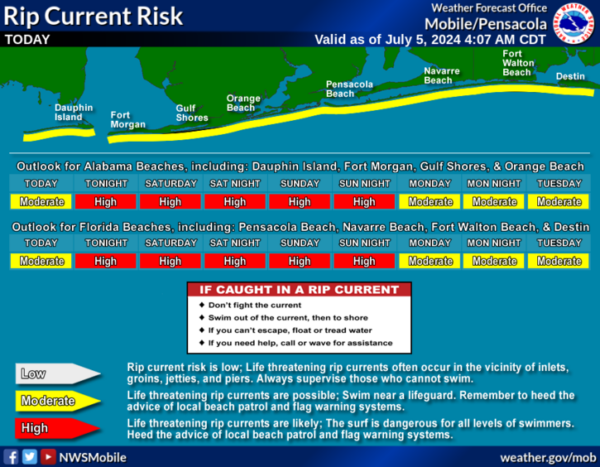
Get the latest weather and rip current forecasts for the beaches from Fort Morgan to Panama City on our Beach Forecast Center page. There, you can select the forecast of the region that you are interested in visiting.
WORLD TEMPERATURE EXTREMES: Over the last 24 hours, the highest observation outside the U.S. was 120.2F at Badrah, Iraq. The lowest observation was -86.8F at Concordia, Antarctica.
CONTIGUOUS TEMPERATURE EXTREMES: Over the last 24 hours, the highest observation was 125F at Death Valley, CA. The lowest observation was 22F at Peter Sinks, UT.
Category: Alabama's Weather, ALL POSTS
About the Author (Author Profile)
Macon, Georgia Television Chief Meteorologist, Birmingham native, and long time Contributor on AlabamaWX. Stormchaser. I did not choose Weather, it chose Me. College Football Fanatic. @Ryan_StinnetSubscribe
If you enjoyed this article, subscribe to receive more just like it.


