
Quick Check on Beryl at 10:30 p.m. CDT
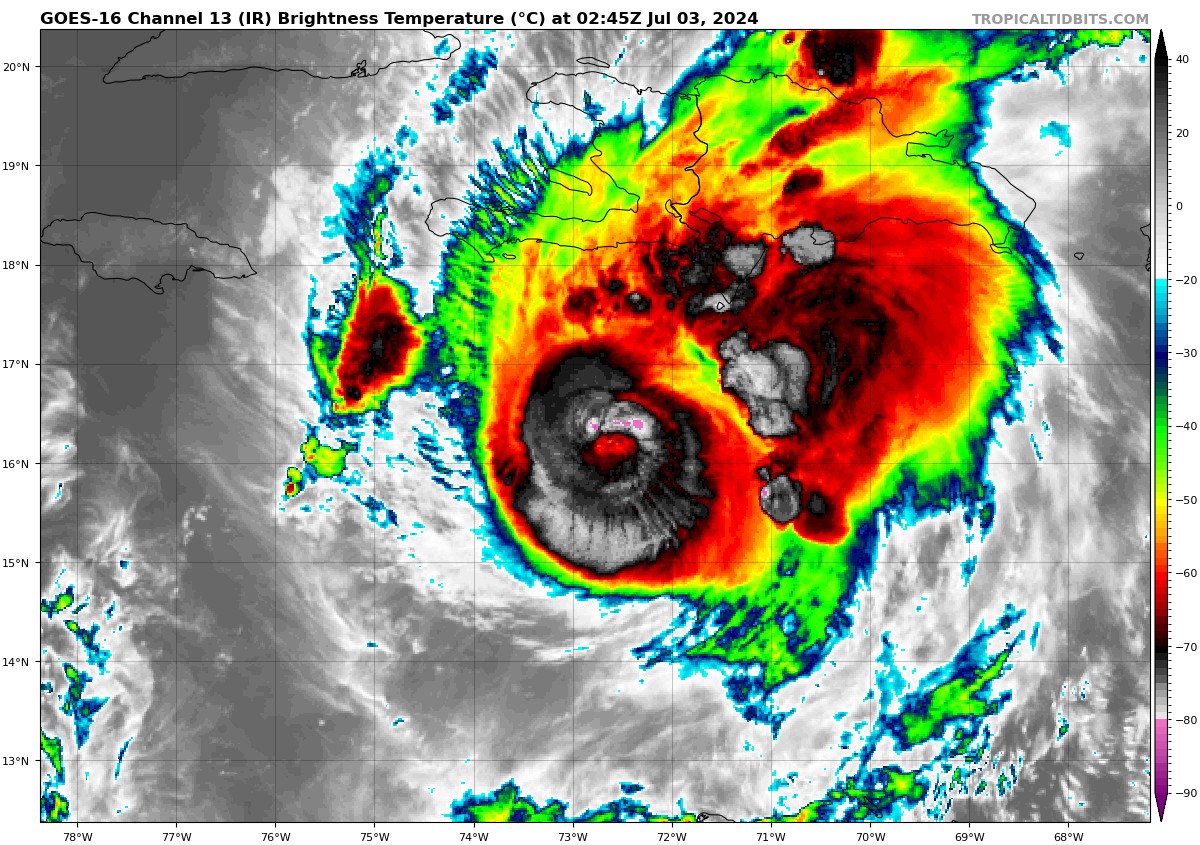
Hurricane Beryl is still very dangerous tonight with top winds of 150 mph. Minimum pressure is 947 mb. NOAA Hurricane Hunters found surface gusts to 159 mph still. Flight level winds were as high as 135 knots, which translates to 140 mph.
It is moving WNW at 22 mph.
Some of the deepest and coldest convection we have seen is bursting around the center tonight. The eye is still partially obscured by clouds. The storm may be undergoing another eyewall replacement tonight. Outer feeder bands of storms seem to be increasing and the storm may be ready to expand in size.
If is the storm is maintaining strength or even strengthening, it will be very bad news for Jamaica, which will absorb a direct hit tomorrow around lunchtime. Even if it weakens as forecast, the devastation will be terrible. Tropical storm force winds will begin early tomorrow morning on the island, with strong tropical storm force winds expected to arrive around 8 a.m. CDT on the southeast coast near Port Morant, and in Kingston a short time later. The northern eyewall will cut like a buzzsaw across the southern part of the island during the day. Hurricane force winds will begin around 9 a.m. and move east to west, ending near Savannah-La-Mer aorund 6 p.m. CDT tomorrow evening. A surge of 4-8 feet is expected, and the 4-8 rains with isolated amounts to near 1 foot will cause terrible flooding and mudslides.
It will bring strong tropical storm force winds to the Caymans early Thursday morning. It should pass far enough south to preclude there being hurricane force winds there.
The center will reach the coast of the Yucatan early Friday morning and emerge into the southwestern Gulf Friday evening.
It is then forecast to move onto the Mexican coast south of Brownsville TX Sunday evening. But there are some increasing signs that it may make landfall on the Texas coast. The GFS ensembles have made a big shift in that direction. And the Euro ensemble information is incomplete tonight, but they also show that as a possibility.
The HWRF is the most concerning model to me. It shows a 958 mb strengthening hurricane approaching the middle Texas coast somewhere between Corpus Christi and Houston Sunday night.
About the Author (Author Profile)
Bill Murray is the President of The Weather Factory. He is the site's official weather historian and a weekend forecaster. He also anchors the site's severe weather coverage. Bill Murray is the proud holder of National Weather Association Digital Seal #0001 @wxhistorianSubscribe
If you enjoyed this article, subscribe to receive more just like it.


