
Scattered Showers/Storms Return Tomorrow
QUIET AFTERNOON: Showers are very hard to find across Alabama this afternoon… we see just a few small, isolated ones over the southern third of the state. Temperatures are in the 90s over West and South Alabama, but many communities over the eastern part of the state are only in the 80s thanks to an easterly flow. Tonight will be mostly fair with a low in the 70s.

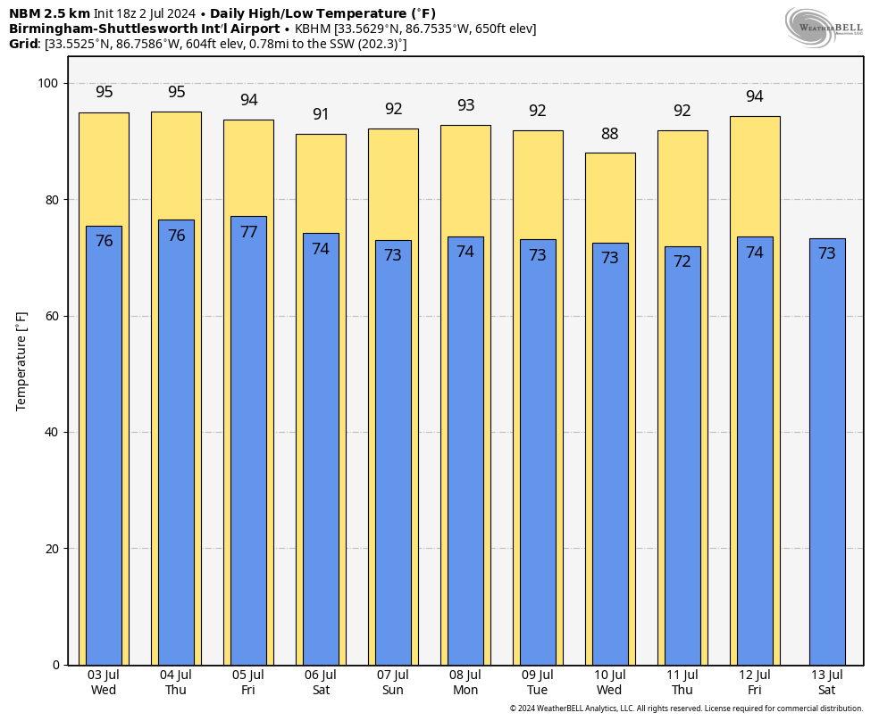
Moisture levels rise tomorrow, and we will mention the chance of an afternoon shower or thunderstorm in scattered spots. The high will be in the 93-97 degree range.
THURSDAY THROUGH THE WEEKEND: We expect very classic summer weather on these four days. Hot and humid, a partly sunny sky, and random, scattered showers and thunderstorms around mostly during the afternoon and evening hours. Chance of any one spot getting wet each afternoon is 30-40 percent Thursday, and 50-60 percent Friday through Sunday. You might get one inch of rain, your neighbor gets nothing. Highs will be in the low to mid 90s.
Not much change next week as the summer pattern persists. Hot, muggy days with the daily chance of a pop-up shower or thunderstorm, mostly between 1:00 and 10:00 p.m. See the video briefing for maps, graphics, and more details.
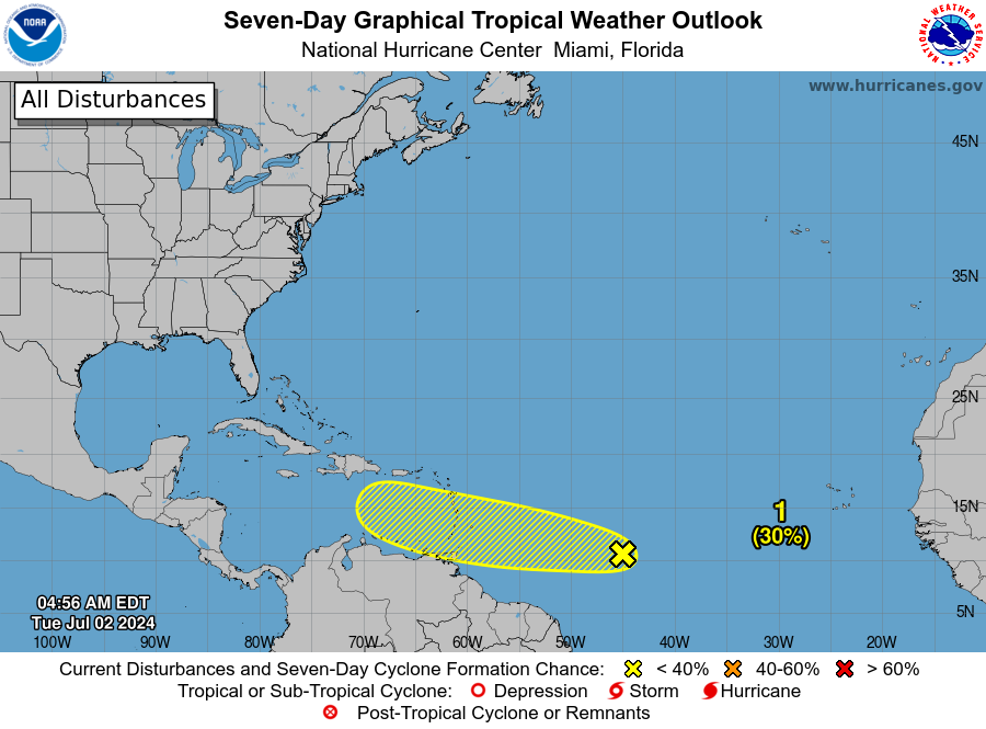
TROPICS: This afternoon Hurricane Beryl is packing sustained winds of 155 mph, and is about 485 miles east/southeast of Kingston, Jamaica. A Hurricane Warning is in effect for Jamaica, where hurricane conditions are expected tomorrow.
There is general agreement in the guidance that Beryl should weaken due to westerly shear and possible land interaction as it approaches Jamaica. It is forecast to still be a hurricane when it reaches the Yucatan Peninsula Friday. The system will emerge into the Southwest Gulf of Mexico as a tropical storm Friday night, and the latest NHC track brings it to a point over far northern Mexico, or the southern tip of Texas Sunday evening. This actually could bring beneficial rain to parts of Texas.

There will be no direct weather impact on the Central Gulf Coast (Gulf Shores to Panama City Beach).
We note another tropical wave is trailing Beryl in the Atlantic, Invest 96L. The chance of development with this system has dropped to 20 percent; it remains just something to watch for now with very dry air surrounding the system.
ON THIS DATE IN 1843: An alligator reportedly fell from the sky onto Anson Street in Charleston, SC during a thunderstorm.
ON THIS DATE IN 2001: In Michigan, frost and freezing temperatures were observed in some locations with Grant dropping to 29 degrees. Muskegon reported their coldest July temperature on record with 39 degrees.
Look for the next video briefing here by 6:00 a.m. tomorrow…
Category: Alabama's Weather, ALL POSTS, Weather Xtreme Videos
About the Author (Author Profile)
James Spann is one of the most recognized and trusted television meteorologists in the industry. He holds the AMS CCM designation and television seals from the AMS and NWA. He is a past winner of the Broadcast Meteorologist of the Year from both professional organizations.Subscribe
If you enjoyed this article, subscribe to receive more just like it.


