

1 p.m. Advisory: Beryl Now 150 mph and Entering Southeastern Caribbean
BULLETIN
Hurricane Beryl Intermediate Advisory Number 12A
NWS National Hurricane Center Miami FL AL022024
200 PM AST Mon Jul 01 2024
…EXTREMELY DANGEROUS BERYL ENTERS THE SOUTHEASTERN CARIBBEAN…
…LIFE-THREATENING WINDS AND DANGEROUS STORM SURGE CONDITIONS
CONTINUE OVER THE SOUTHERN WINDWARD ISLANDS…
SUMMARY OF 200 PM AST…1800 UTC…INFORMATION
———————————————-
LOCATION…12.8N 62.3W
ABOUT 60 MI…100 KM WNW OF CARRIACOU ISLAND
ABOUT 65 MI…105 KM NW OF GRENADA
MAXIMUM SUSTAINED WINDS…150 MPH…240 KM/H
PRESENT MOVEMENT…WNW OR 285 DEGREES AT 20 MPH…31 KM/H
MINIMUM CENTRAL PRESSURE…946 MB…27.94 INCHES
WATCHES AND WARNINGS
——————–
CHANGES WITH THIS ADVISORY:
The government of Barbados has discontinued the Hurricane Warning
for the island.
The government of Trinidad and Tobago has discontinued the Hurricane
Warning for Tobago and discontinued the Tropical Storm Warning for
Trinidad.
SUMMARY OF WATCHES AND WARNINGS IN EFFECT:
A Hurricane Warning is in effect for…
* St. Vincent and the Grenadine Islands
* Grenada
A Hurricane Watch is in effect for…
* Jamaica
A Tropical Storm Warning is in effect for…
* Martinique
* St. Lucia
A Tropical Storm Watch is in effect for…
* South coast of Dominican Republic from Punta Palenque westward
to the border with Haiti
* South coast of Haiti from the border with the Dominican
Republic to Anse d’Hainault
A Hurricane Warning means that hurricane conditions are expected
somewhere within the warning area.
A Hurricane Watch means that hurricane conditions are possible
within the watch area. A watch is typically issued 48 hours
before the anticipated first occurrence of tropical-storm-force
winds, conditions that make outside preparations difficult or
dangerous.
A Tropical Storm Warning means that tropical storm conditions are
expected somewhere within the warning area within 36 hours.
A Tropical Storm Watch means that tropical storm conditions are
possible within the watch area, generally within 48 hours.
Interests elsewhere in the Lesser Antilles, the Cayman Islands, and
the remainder of the northwestern Caribbean should closely monitor
the progress of Beryl. Additional watches or warnings may be
required tonight or on Tuesday.
For storm information specific to your area, please monitor
products issued by your national meteorological service.
DISCUSSION AND OUTLOOK
———————-
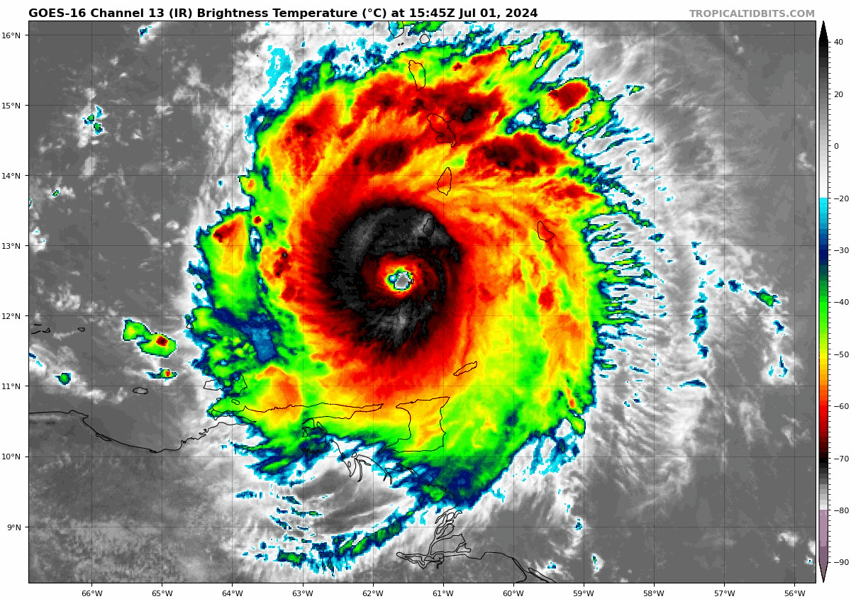
At 200 PM AST (1800 UTC), the eye of Hurricane Beryl was located
near latitude 12.8 North, longitude 62.3 West. Beryl is moving
toward the west-northwest near 20 mph (31 km/h). The center of Beryl
will move away from the southern Windward Islands tonight and pass
quickly westward to west-northwestward during the next few days. On
the forecast track, the center of Beryl will move across the
southeastern and central Caribbean Sea tonight through Wednesday.
Maximum sustained winds are near 150 mph (240 km/h) with higher
gusts. Beryl is a category 4 hurricane on the Saffir-Simpson
Hurricane Wind Scale. Fluctuations in strength are likely during the
next day or so, but Beryl is expected to remain an extremely
dangerous major hurricane as its moves over the eastern Caribbean.
Some weakening is expected in the central Caribbean by midweek,
though Beryl is forecast to remain a hurricane.
Hurricane-force winds extend outward up to 40 miles (65 km) from
the center and tropical-storm-force winds extend outward up to 125
miles (205 km). The Hewanorra International Airport on St. Lucia
recently reported sustained winds of 43 mph (69 km/h).
The minimum central pressure based on aircraft data is 946 mb
(27.94 inches).
HAZARDS AFFECTING LAND
———————-
Key messages for Beryl can be found in the Tropical Cyclone
Discussion under AWIPS header MIATCDAT2 and WMO header WTNT42 KNHC.
WIND: Hurricane conditions are occurring in the hurricane warning
area. Potentially catastrophic wind damage is expected where the
core of Beryl is moving through portions of the southern Windward
Islands, including Carriacou Island, Grenada, and the Grenadine
Islands.
Wind speeds atop and on the windward sides of hills and mountains
are often up to 30 percent stronger than the near-surface winds
indicated in this advisory, and in some elevated locations could be
even greater.
Hurricane conditions are possible in the watch area on Jamaica by
Wednesday.
Tropical storm conditions are occurring in the tropical storm
warning area. Tropical storm conditions are possible within the
watch area by Tuesday afternoon for parts of the southern coast of
Hispaniola.
STORM SURGE: A life-threatening storm surge will raise water levels
by as much as 6 to 9 feet above normal tide levels in areas of
onshore winds near where the eye makes landfall in the hurricane
warning area. Near the coast, the surge will be accompanied by
large and destructive waves.
RAINFALL: Hurricane Beryl is expected to produce rainfall totals of
3 to 6 inches across Barbados and the Windward Islands through this
afternoon. Localized maxima of 10 inches are possible, especially in
the Grenadines, Tobago, and Grenada. This rainfall may cause flash
flooding in vulnerable areas.
For a complete depiction of forecast rainfall and flash flooding
associated with Hurricane Beryl, please see the National Weather
Service Storm Total Rainfall Graphic, available at
hurricanes.gov/graphics_at2.shtml?rainqpf
SURF: Large swells generated by Beryl will continue across the
Windward and southern Leeward Islands during the next couple of
days. Swells are also expected to reach the southern coasts of
Puerto Rico and Hispaniola late tonight into Tuesday. These swells
are expected to cause life-threatening surf and rip current
conditions. Please consult products from your local weather office.
NEXT ADVISORY
————-
Next complete advisory at 500 PM AST.
$$
Forecaster Reinhart
About the Author (Author Profile)
Bill Murray is the President of The Weather Factory. He is the site's official weather historian and a weekend forecaster. He also anchors the site's severe weather coverage. Bill Murray is the proud holder of National Weather Association Digital Seal #0001 @wxhistorianSubscribe
If you enjoyed this article, subscribe to receive more just like it.


