
Midday Nowcast: Hot July Days; Beryl Stronger
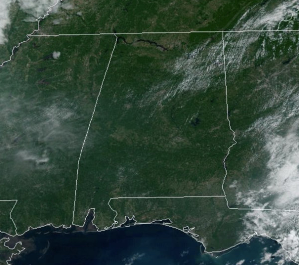
WELCOME TO JULY: Hot summer days are here to stay, but thankfully, some drier air is dropping into the northern 2/3 of Alabama today, dropping our humidity levels. Most of the afternoon showers and storms will be confined to the southeast counties of the state. Highs are in the 90s this afternoon. Not much change through Wednesday; afternoon showers will be few and far between with highs mostly in the mid 90s.
BIRMINGHAM ALMANAC: For July 1st, the average high for Birmingham is 90° and the average low is 71°. The record high is 104° set in 2012, while the record low is 54° set in 1950. We average 0.18” of precipitation on this date, and the record value is 2.67” set in 2003.
USA BRIEF: Hot conditions will continue across the southern Plains and lower Mississippi Valley, while simmering heat builds throughout California’s Central Valley this week. Numerous new records expected. Heavy rain and flash flooding for parts of the Southeast coastline today and Central/Southern Rockies. Severe thunderstorms and heavy rain threat situated over northern Plains and Midwest early this week.
INDEPENDENCE DAY WEEKEND: It is a long holiday weekend for most folks and scattered showers and storms will become more numerous across Alabama as the air becomes more unstable, and moisture levels rise. The chance of any one spot getting wet these days is 30/40 percent, and highs will remain in the 90s. This pattern will continue for Saturday and Sunday.
NEXT WEEK: We will roll with a persistence forecast. Hot, humid, a few spotty showers and thunderstorms around on a daily basis with highs in the 90s and lows in the 70s.
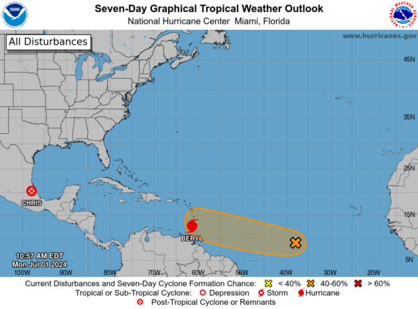
IN THE TROPICS: The swirl known as Chris has dissipated over Mexico and Beryl remains a major hurricane. Behind Berly, we are watching Invest 96L: Showers and thunderstorms continue in association with an area of low pressure located over 1000 miles east-southeast of the Windward Islands. Environmental conditions appear marginally conducive for additional development of this system, and a tropical depression could form by the middle part of this week while it moves generally westward at 15 to 20 mph across the central and western tropical Atlantic. Interests in the Lesser Antilles should monitor the progress of this system. Formation chance through 7 days…medium…60 percent.
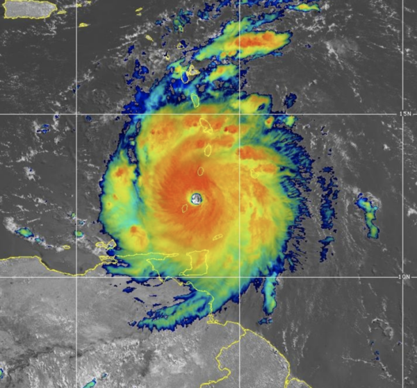
Hurricane Beryl satellite imagery and Barbados radar data indicate that the eye of Beryl has made landfall on Carriacou Island at 1110 AM AST. Data from an Air Force Reserve Hurricane Hunter aircraft indicate that Beryl’s maximum sustained winds have increased to 150 mph. The latest minimum central pressure estimated from reconnaissance data is 950 mb (28.05 inches). Fluctuations in strength are likely during the next day or so, but Beryl is expected to remain an extremely dangerous major hurricane as its core moves through the Windward Islands into the eastern Caribbean. Some weakening is expected in the central Caribbean by midweek, though Beryl is forecast to remain a hurricane.

Beryl is expected to move quickly westward to west-northwestward during the next few days. On the forecast track, the center of Beryl is currently moving across the southern Windward Islands and will move across the southeastern and central Caribbean Sea late today through Wednesday.
BEACH FORECAST CENTER: Highs in the upper 80s and low 90s with storms. Water temperatures are very warm with mid-80s being reported up and down the Northern Gulf Coast. PLEASE pay attention to the Rip Current Flags System at each beach for the update on rip currents. Moderate rip currents are being reported from Dauphin Island east to Panama City.
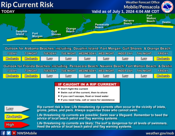
Get the latest weather and rip current forecasts for the beaches from Fort Morgan to Panama City on our Beach Forecast Center page. There, you can select the forecast of the region that you are interested in visiting.
WORLD TEMPERATURE EXTREMES: Over the last 24 hours, the highest observation outside the U.S. was 122.5F at Hassi-Messaoud, Algeria. The lowest observation was -90.6F at Concordia, Antarctica.
CONTIGUOUS TEMPERATURE EXTREMES: Over the last 24 hours, the highest observation was 118F at Death Valley, CA. The lowest observation was 31F at Mackay, ID.
Category: Alabama's Weather, ALL POSTS
About the Author (Author Profile)
Macon, Georgia Television Chief Meteorologist, Birmingham native, and long time Contributor on AlabamaWX. Stormchaser. I did not choose Weather, it chose Me. College Football Fanatic. @Ryan_StinnetSubscribe
If you enjoyed this article, subscribe to receive more just like it.


