Tropics Very Active
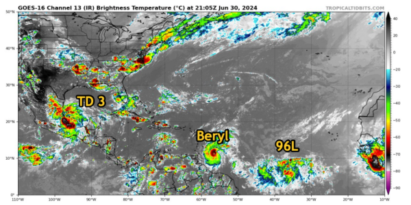
TROPICAL DEPRESSION THREE
TD Three has formed over the far southwestern Gulf of Mexico.
Tropical storm warnings have been issued for the Mexican Coast from Cabo Rojo to Puerto Veracruz.
It should move inland overnight along the Mexican coast. There is a good chance it could briefly become a tropical storm before it does. Winds could reach 40 mph. It would likely be named Chris.
INVEST 96L
Invest 96L is located about 1,200 miles east of Beryl. The NHC says it has a 70% chance of developing into a tropical cyclone over the next 7 days.
The HAFS-A forecast model shows a 980 mb and 65 mph tropical storm. The HAFS-b is a little stronger and slower to reach the islands near Barbados.
BERYL
Hurricane Beryl is a dangerous category four hurricane wind top winds of 130 mph. The Hurricane Hunters has departed the area. Two more missions are tasked for the evening and overnight hours.
‘
The track is edged just a little to the north with tropical storm force winds affecting Jamaica Wednesday and the Caymans on Thursday morning, then the Yucatan Friday night into Saturday, entering the southwestern Gulf of Mexico by Sunday. Where it goes from there is just speculation at this point.
The warnings in the Windward Islands are unchanged, but there is now a tropical storm watch for southern portions of Haiti and the Dominican Republic. Those conditions would occur during the day Tuesday.
We don’t usually see our first hurricane until 8/11 on average, and September 1 for the first major hurricane, so I fear for the rest of the season.
The storm is historic. There has only been one hurricane east of the Lesser Antilles since 1933. Only two major hurricanes have been recorded south of Martiniquwe since 1851: 1980’s Hurricane Allen and 2004’s Hurricane Ivan. Beryl is only the second June hurricane for form east of the Windward Islands. There was another in 1933.


