Midday Nowcast: Some Showers and Storms Today
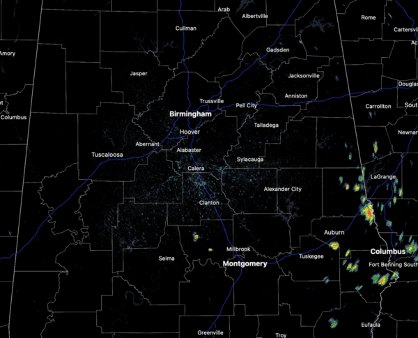
TODAY THROUGH THE WEEKEND: Routine summer weather is in the forecast with partly sunny, hot, humid days with the usual risk of scattered showers and storms on a daily basis generally during the afternoon and evening hours. Highs should be in the low to mid 90s, and with the higher humidity levels, heat index values should be near the 100° mark. The chance of any one given community seeing rain will be in the 30-40% range today, increase to the 50-60% tomorrow and Sunday. No weekend washout, but just be prepared to dodge some rain and avoid lightning through the weekend.
BIRMINGHAM ALMANAC: For June 28th, the average high for Birmingham is 90° and the average low is 71°. The record high is 104° set in 1931, while the record low is 53° set in 1968. We average 0.17” of precipitation on this date, and the record value is 3.51” set in 1999.
ACROSS THE USA: Severe thunderstorms may develop from parts of the central Plains into parts of the Middle and Upper Mississippi Valley today. Large hail and damaging winds are the primary threats, as well as a couple tornadoes possible. Heat will continue across the southern Plains for the remainder of the week, with several record tying/breaking highs possible.
NEXT WEEK: Hotter temperatures will return as the upper ridge will strengthen, and rain chances look to decrease. Expect highs to return to the upper 90s and likely some low 100s. A few afternoon showers and storms are possible daily with an increasing coverage for the second half of the week.
IN THE TROPICS: Three areas the NHC is monitor for potential development over the next week. One of which will likely become a depression over the next couple to days.
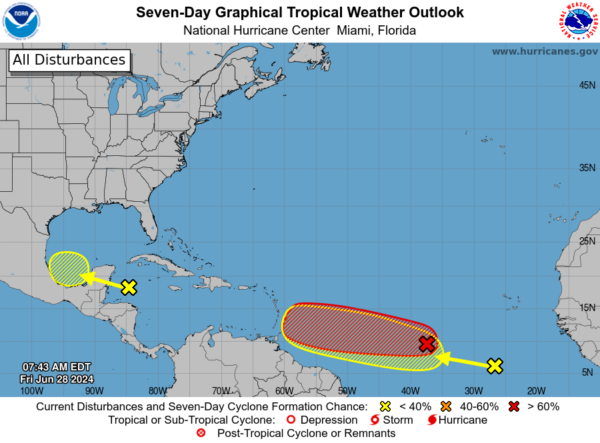
1. Western Caribbean/Southwestern Gulf of Mexico (AL94): A broad area of low pressure over the western Caribbean Sea associated with a tropical wave continues to produce widespread shower and thunderstorm activity. Development of this system is not expected today while it moves west-northwestward at around 15 mph, and an Air Force reconnaissance mission planned for today has been canceled. The disturbance is then expected to move westward over the Yucatan Peninsula and emerge over the Bay of Campeche late Saturday or early Sunday, at which point some development will be possible. Regardless of development, heavy rainfall associated with the tropical wave will affect portions of Central America and Mexico through the weekend. Formation chance through 7 days…low…30 percent.
2. Central Tropical Atlantic (AL95): A low pressure system located about 1500 miles east-southeast of the Windward Islands is gradually becoming better defined. Showers and thunderstorms are also showing signs of organization, and a tropical depression or tropical storm will likely form later today or on Saturday. This system is expected to move westward at 15 to 20 mph and approach the Lesser Antilles by the end of the weekend. Interests there should monitor the progress of this system. Formation chance through 48 hours…high…90 percent. This system will likely become Beryl and will be in the Caribbean next week, after that, we will just have to wait and see, but we are keeping an eye on it for sure.
3. Eastern Tropical Atlantic: A tropical wave centered several hundred miles south-southwest of the Cabo Verde Islands is producing disorganized showers and thunderstorms. Some slow development of this system is possible next week while it moves generally westward across the central and western tropical Atlantic at 15 to 20 mph. Formation chance through 7 days…low…20 percent.
Next names up are Beryl, Chris, and Debby.
BEACH FORECAST CENTER: Highs in the mid to upper 80s daily rain and storms. Water temperatures are very warm with mid-80s being reported up and down the Northern Gulf Coast. Again, PLEASE pay attention to the Rip Current Flags System at each beach for the update on rip currents. Moderate rip currents are being reported from Dauphin Island east to Panama City.
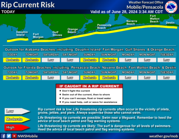
Get the latest weather and rip current forecasts for the beaches from Fort Morgan to Panama City on our Beach Forecast Center page. There, you can select the forecast of the region that you are interested in visiting.
WORLD TEMPERATURE EXTREMES: Over the last 24 hours, the highest observation outside the U.S. was 122.5F at Ouargia, Algeria. The lowest observation was -107.9F at Concordia, Antarctica.
CONTIGUOUS TEMPERATURE EXTREMES: Over the last 24 hours, the highest observation was 120F at Death Valley, CA. The lowest observation was 25F at Mackay, ID.
Category: Alabama's Weather, ALL POSTS
About the Author (Author Profile)
Macon, Georgia Television Chief Meteorologist, Birmingham native, and long time Contributor on AlabamaWX. Stormchaser. I did not choose Weather, it chose Me. College Football Fanatic. @Ryan_StinnetSubscribe
If you enjoyed this article, subscribe to receive more just like it.


