
Midday Nowcast: Not as Hot with Scattered Showers and Storms
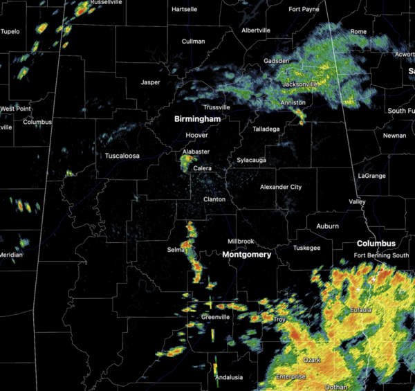
Scattered showers and storms remain in the forecast today, with the higher coverage over southern portions of the state. It is not as hot this afternoon with highs only in the upper 80s with some low 90s. Certainly a welcomed sight across the state.
BIRMINGHAM ALMANAC: For June 27th, the average high for Birmingham is 90° and the average low is 71°. The record high is 102° set in 1954, while the record low is 53° set in 1974. We average 0.17” of precipitation on this date, and the record value is 1.80” set in 1926.
ACROSS THE USA: Severe thunderstorms capable of very large hail and damaging wind gusts around 80 mph are forecast across portions of the central and northern Plains today into the nighttime hours; Furthermore, locally heavy rainfall may result in isolated instances of flash flooding. Monsoon-like conditions persist for the Four Corners Region where additional flooding is possible through tonight.
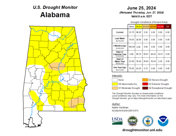
DROUGHT CONDITIONS: The latest drought monitor was release today, and as expected with the recent dry weather and blistering heat, abnormally dry and drought conditions have developed and expanded rapidly across portions of Alabama. Moderate drought covers portions of Shelby, Talladega, Coos, Chilton, and Bibb counties, as well we western portions of Pickens County. More drought down in the Wiregrass Region. Most of the rest of the state is dealing with Abnormally Dry conditions. Thankfully, there continues to be decent rain chances in the forecast.
TOMORROW AND THE WEEKEND: Routine summer weather is in the forecast. Expect partly sunny, hot, humid days with the usual risk of scattered showers and storms on a daily basis generally during the afternoon and evening hours. Highs should be in the low to mid 90s, and with the higher humidity levels, heat index values should be near the 100° mark. The chance of any one given community seeing rain will be in the 40-50% range. No weekend washout, but just be prepared to dodge some rain and avoid lightning through the weekend.
NEXT WEEK: Hotter temperatures will return as the upper ridge will strengthen, and rain chances look to decrease. Expect highs to return to the upper 90s and likely some low 100s. A few afternoon showers and storms are still possible.
IN THE TROPICS: Two areas the NHC is monitor for potential development over the next week.
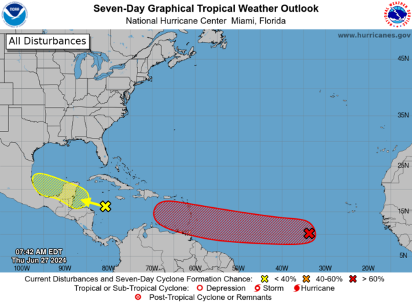
1. Western Caribbean/Southwestern Gulf of Mexico (AL94): A tropical wave over the western Caribbean Sea is producing widespread but disorganized shower and thunderstorm activity while it moves westward at around 20 mph. Some development of this system is possible over the northwestern Caribbean Sea or over the southwestern Gulf of Mexico during the next several days. Formation chance through 7 days…low…30 percent.
2. Eastern Tropical Atlantic (AL95): A tropical wave located several hundred miles west-southwest of the Cabo Verde Islands continues to produce disorganized shower and thunderstorm activity. Environmental conditions are forecast to be conducive, and development of this system is anticipated. A tropical depression or tropical storm is likely to form this weekend several hundred miles east of the Windward Islands while the system moves westward at 15 to 20 mph. Formation chance through 7 days…high…70 percent.
Next names up are Beryl and Chris.
BEACH FORECAST CENTER: Highs in the mid to upper 80s daily rain and storms. Water temperatures are very warm with mid-80s being reported up and down the Northern Gulf Coast. Again, PLEASE pay attention to the Rip Current Flags System at each beach for the update on rip currents. Moderate rip currents are being reported from Dauphin Island east to Panama City.
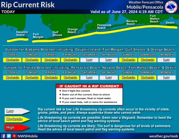
Get the latest weather and rip current forecasts for the beaches from Fort Morgan to Panama City on our Beach Forecast Center page. There, you can select the forecast of the region that you are interested in visiting.
WORLD TEMPERATURE EXTREMES: Over the last 24 hours, the highest observation outside the U.S. was 120.6F at Ouargia, Algeria. The lowest observation was -101.2F at Concordia, Antarctica.
CONTIGUOUS TEMPERATURE EXTREMES: Over the last 24 hours, the highest observation was 120F at Death Valley, CA. The lowest observation was 29F at Kirk, OR.
Category: Alabama's Weather, ALL POSTS
About the Author (Author Profile)
Macon, Georgia Television Chief Meteorologist, Birmingham native, and long time Contributor on AlabamaWX. Stormchaser. I did not choose Weather, it chose Me. College Football Fanatic. @Ryan_StinnetSubscribe
If you enjoyed this article, subscribe to receive more just like it.


